

gymengineer
-
Posts
3,242 -
Joined
-
Last visited
Content Type
Profiles
Blogs
Forums
American Weather
Media Demo
Store
Gallery
Posts posted by gymengineer
-
-
92,000+ customers without power in VA now and rapidly climbing.
-
Just now, Eskimo Joe said:
Wind Chill Advisory coming out for DC/Baltimore metros. Should populate on NWS website shortly.
Do you have a link to a source that lists what the warning hierarchy is to determine which color we see on the NWS map when multiple warnings/advisories are in place? Like, flash flood and tornado warnings will always be primary, but between a winter weather advisory and a wind chill advisory, for example, which one takes precedence on the map? Thanks in advance!
-
 1
1
-
-
1 minute ago, stormtracker said:
 . You know I liked it, but it is much for this fine G rated forum.
I’m trying to remember what triggered that blowout fight amongst you, Matt, and maybe Ian was involved too, that resulted in you posting very NSFW pics. IIRC, meanwhile, Wes just calmly minded his own business and continued posting about the weather. Fun times!
")
-
 1
1
-
-
If you had a friend you had to advise about cross country travel late next week, what would you say?
To me, it’s relatively straightforward in just saying there’s going to be a storm with very low pressure resembling the pressure of a strong hurricane. The path will dictate everything else.
The amount of detail that still has to be worked out is huge, but can we not just appreciate the pressure bombs these outputs keep on releasing?
-
 2
2
-
-
5 minutes ago, Always in Zugzwang said:
I was living in the Capitol Hill neighborhood in DC at the time. I do remember that early morning wet snow Christmas morning, like rain changed to snow for a time I think. We didn't get a lot other than to whiten the grass a bit, but it was pretty cool for awhile!
Got it. Yeah, it was one of those “west of the Fall Line” situations for accumulation.
-
3 minutes ago, Always in Zugzwang said:
Yup...both the GFS and Euro would be a white Christmas with a very wintry feel. If that were to occur, it would be the only "truly" wintry Christmas that I can recall since I moved to this area (in 2001). You could say we technically had a white Christmas in 2009 with the leftover snow pack from that Dec. 18-19 storm. But even then, it was being washed away right on Christmas with rain.
And it beats the hell out of 65-70 and humid.
Were you too far south or east for the 2002 Christmas morning “miracle?”
-
6 minutes ago, Cobalt said:
For the data-obsessed weather geeks like myself out there, it looks like the team that creates the NESIS snowfall map graphics went back and filled in the gaps for some of the storms from the 2000s-today. The graphics don't look as polished as some of the earlier ones, but it's nice to see some love for the storms that were somewhat prolific, but might've just not been considered at the end of their respective seasons. You can find that data here:
https://www.ncei.noaa.gov/access/monitoring/rsi/nesis
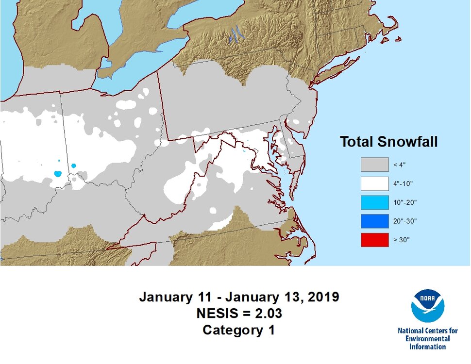
This was a personal favorite of mine.
I love the NESIS maps. I print them out and have them on my nightstand like other people would have pictures of their kids. I flip through my stack every night before turning off the lights to go to bed.
-
1
-
7
-
-
19 minutes ago, psuhoffman said:
It was the only good snow that winter in northern VA. My senior year at Oakton HS. It was in the mid 30s as the snow began then temps quickly fell to 33 then 32 as the intensity increased. Eventually towards the very end of the storm that evening temps dropped below freezing. I think the temp splits for the day were 37/29 at IAD and 39/31 at DCA.
Yeah, it didn’t begin to stick on roads in suburban MoCo until the sun went down, by which point most of the precip was done. Kind of like 2/24/05 and 2/28/05 but even less road accumulations.
To your greater point of marginal not working out in our changed climate, I think another example would be February 1986 (the month, not just one event). I don’t think a repeat would result in 13” at DCA.
-
1 hour ago, WxWatcher007 said:
Don’t think I’ve seen you posting recently. Good to see it. Hope all is well.
Thank you so much! I did tiptoe into some of the hurricane threads from September onward.
I was already posting less year to year because of life stuff, but I think winter 20/21 kind of broke me. Don’t remember if there was a thread that diagnosed why short term modeling sucked so much that winter. We endured so many WSW’s that busted. Even what was going to be the biggest snow turned into a sleet bomb hours before but there was not even a sleet bomb because the QPF busted while the event was occurring.
I hope all’s well with you too.
-
2
-
-
2 hours ago, CAPE said:
Wasn't that the year where it snowed for Thanksgiving(more SE of I-95), Dec was super cold, the Bay froze, then by mid Jan winter was over?
It did snap back for a cold, active period from late March into early April. Too late in the calendar for much road sticking, but there were 3 accumulating snow events nevertheless all the way down into urban areas, including one in April. IAD recorded 10.4” in March and April.
With temps so marginal, though, a repeat of that pattern probably wouldn’t result in all 3 events having snow in the urban corridor today.-
1
-
-
This is an incredible watch by the man whose probe captured the infamous storm surge video. The interview with the couple whose house was being destroyed in the video while they were still inside is jaw dropping.
-
4
-
1
-
-
-
1 hour ago, mattie g said:
You have to account for inflation in all of these calculations, though.
Oh, absolutely. And I included inflation as a factor in my post. It’s definitely not the only factor though. The first list in this document from the NHC accounts for inflation:
https://www.ncei.noaa.gov/access/billions/dcmi.pdf
The top spots of the list still tilt towards more recent years. And comparing individual cases, inflation doesn’t fix the discrepancies. Like Ivan vs. Frederick is way too large a gap. And no way a repeat of Carol today would be just at Isaias’ level of damage.
-
On 10/11/2022 at 9:01 PM, Terpeast said:
Hmm. Worth noting 2000 and 2011 were both Ninas, and had 119+ ACE. But 1985, also a nina, finished at only 88.
Interesting to compare to 1985. A repeat of that season now would be far more devastating than 1985 turned out. It was the most expensive hurricane season for the US up to that point, but Hugo in '89 showed next level possibility in damage. With sea level rise, coastal population explosion, and inflation, those 6 US hurricane landfalls from 1985 would likely total well into the tens of billions nowadays.
These past few seasons have shown how vulnerable presently the US is to hurricane damage. The last 11 consecutive US hurricane landfalls have all been billion-dollar disasters: Ian, Fiona, Nicholas, Ida, Zeta, Delta, Sally, Laura, Isaias, Hanna, and Dorian. Four of these were Category 1 landfalls. Barry in 2019 was the last US hurricane landfall to not hit $1 billion in damage. In the 1980's, a hurricane like Nicholas would probably not even hit $100 million in damage.
Even tropical storm landfalls now with some frequency hit the billion dollar damage mark: Fred, Elsa, Eta, Imelda, for example.
-
1
-
-
1 hour ago, brooklynwx99 said:
I also agree with (and have been agreeing w/ for a while) @40/70 Benchmark that the start of this winter will hold some surprises. early-season blocking is favored by analogs like 2000-01, 2020-21, 2017-18, 2021-22, and even 2010-11! and yes, I know there was some bad luck here with 2010-11, but you guys would roll the dice with that 500mb pattern every single time
I’m sorry if I’m misinterpreting what you’re saying here. Like, are you including January for the “start of winter?”
The total snow before January from all 5 seasons you listed as analogs is a paltry 6.0” at DCA, so a mean of 1.2” per season. That’s below 1991-2020 climo. -
With Ian's Category 4 landfall, this makes 7 Category 4 or 5 US landfalls in these most recent 6 seasons. This is unprecedented since records have been kept. The previous most Category 4 or 5 US landfalls within 6 seasons was 5 from 1945-1950. All of them hit Florida, and all of them were 115 kt landfalls (the minimum threshold for Category 4).
This makes the intensity of this collection of 7 landfalls stand out even more as extreme:
2017- Harvey, 115 kt
2017- Irma, 115 kt
2017- Maria, 135 kt
2018- Michael, 140 kt
2020- Laura, 130 kt
2021- Ida, 130 kt
2022- Ian, 130 kt (prelim, although I wouldn't expect this to drop under Cat 4 in post analysis)
-
1
-
1
-
-
The global models have been pretty unanimous for the past day or so that Julia would only appreciably strengthen in the window right before landfall. For multiple runs, they’ve been showing steady state until around 8 pm tonight.
-
1
-
-
34 minutes ago, floridapirate said:
This map was posted on 25 Sep, 48 hours before the storm (pulled from the Ian thread). South and east was the way to evacuate, Tampa is on the southern edge of the cone. Ft Myers/Naples isnt even the cone at this point. Forecasting was poor on this one.

That’s why the NHC keeps on telling users not to focus on the center path which will shift around, and that hazards can extend well outside of the cone. The NHC explicitly started predicting a 4-7’ storm surge for Lee County starting at 11 pm on Sunday, 9/25. That prediction never went lower on subsequent advisories. You’re not going to convince many on a weather board that Lee County officials did not have enough information to order evacuations sooner.
-
Duck, NC, is forecasted to reach the third highest water level….not far from the record from Isabel.
-
2
-
1
-
 1
1
-
-
14 minutes ago, Hoosier said:
Anyone have a current death toll from Ian? The numbers I've been finding seem to be outdated.
CNN’s current count is 64 with an update of 35 from Lee County today.
-
People being helped to evacuate flooded homes:
-
2
-
-
1 minute ago, GaWx said:
Winds are now strong from the NW at Georgetown with SLP falling even more rapidly. It doesn't jibe with what Josh and Dr Knabb said.
I didn’t hear Dr. Knabb say what the poster claimed he said and I’ve had the channel on nonstop. He was saying landfall could be any moment, not that Ian had made landfall.
-
1
-
-
5 ft storm surge verified for the Myrtle Beach area:
-
3 minutes ago, StantonParkHoya said:
Josh just said he found the center inland near Awendaw on Twitter. 985mb currently
A later tweet by him has a new center reading of 983 mb. As Dr. Knabb pointed out, the wind direction at Georgetown would shift upon the actual landfall. We’ll wait for the NHC’s verdict.
-
2
-

December 22-23, 2022: Warm Rain to Arctic Chill
in Mid Atlantic
Posted
Three states now with over 100,000 customers without power: NC, VA, TN
11 more states with over 50,000 customers without power.