WestMichigan
-
Posts
1,382 -
Joined
-
Last visited
Content Type
Profiles
Blogs
Forums
American Weather
Media Demo
Store
Gallery
Everything posted by WestMichigan
-
Lake effect compaction and warmer weather, not a good combination if snow depth is your goal.
-
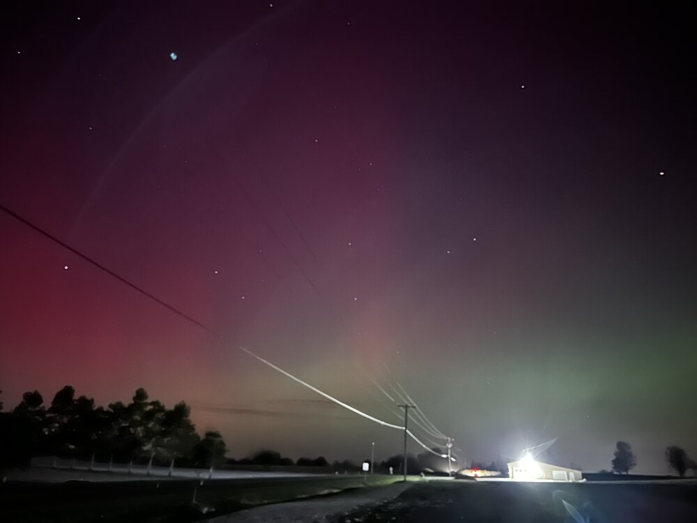
Clouds here but my kids at college in Ohio sent this photo.
-

2025-2026 ENSO
WestMichigan replied to 40/70 Benchmark's topic in Weather Forecasting and Discussion
That was my first winter in Michigan. Came back from Christmas in Ohio to snow on the ground and didn't see grass again until almost the middle of March. -
11/8-11/10 First Snow and Lake Effect Event
WestMichigan replied to Geoboy645's topic in Lakes/Ohio Valley
My ~1.5" yesterday seems pretty paltry compared to these totals. Normally that much on Nov. 9th would be considered a win but not today. Congrats to those to the W/SW of me. -
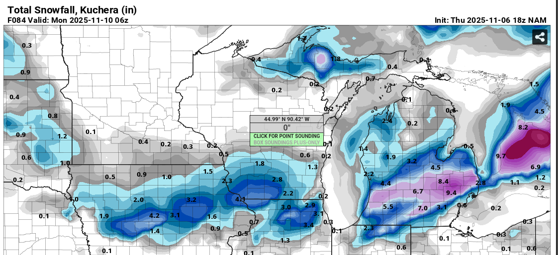
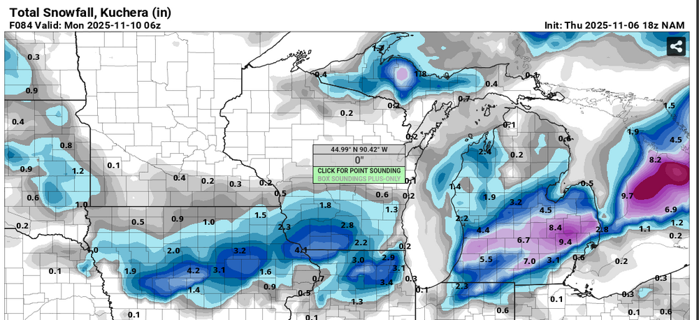
Looks like I am about to get NAM'd. Per usual cut this in half and maybe we are talking something realistic.
-
It is very windy around here at times and those fast growing maples don't always stand up to the wind as well. I have a few sugar maples around the yard. Not as brilliant but the orange is about as beautiful as the reds on the autumn blaze maples.
-
2025-2026 ENSO
WestMichigan replied to 40/70 Benchmark's topic in Weather Forecasting and Discussion
2013-2014 stands out like a sore thumb in the middle of that data. Makes you realize just how much of an anomaly it was. -
This would have been a fantastic LES event in a few months. Regardless I am glad to finally be getting some rain. We could definitely use it.
-
We had a pretty good period of dime to nickel sized hail yesterday afternoon. It was quite noisy at work. I didn't get any pictures but it was quite possibly the largest hail I have ever seen. We normally only get small stuff around here if any at all.
-
Starting with April every month has been below normal in precipitation at GRR including this month so far. The deficit starting with April is not as bad as some places but still a hefty 8.07" below normal since April 1.
-
Three nights in a row this week right before sundown I saw 70+ geese flying overhead here. I think the second night was the largest with approximately 100 or so in the group.
-
Completely off topic but you might want to look into replacing the TPMS sensor(s).
-
Fall 2025 Medium/Long Range Discussion
WestMichigan replied to Chicago Storm's topic in Lakes/Ohio Valley
I can confirm it has been very dry. The rain last week helped a little and the pictures aren't quite that bad now, but it is heading back that direction as we get farther away from the rain last week. Looking forward to a change in the weather next week and hopefully some rain. -
I wonder how much the rain this week will help change the colors on that map a little next week. Unfortunately it looks dry for a while also.
-
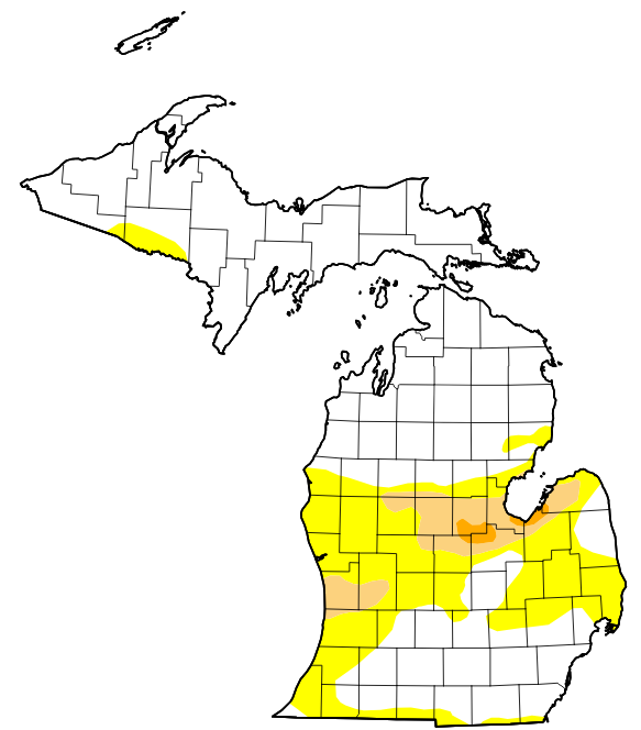
It looks like this week's drought monitor might look a little different across Michigan. Not enough to erase long term deficits but everything is now very green around here.
-
Stealing this from a different subforum here https://www.fox2detroit.com/news/snow-september-michigan-upper-peninsula-reports-first-flakes-year?taid=68b9de3458195e00016720a1
-
Wednesday's rain will certainly help in some of the drier areas of the state. Not a perfect overlay of the driest areas but certainly some welcome precipitation in many areas.
-
Euro says what tropical system. It will be interesting to watch this play out.
-
GFS wants to ease the dry conditions bringing the remnants of a tropical system up the the lower great lakes region. Would certainly help out with the drought in the Ohio region assuming the fantasy land GFS is at all accurate.
-
I saw some personal weather stations near Grayling in the upper 20's. Definitely cold for this time of the year.
-
I drove through that stuff in the Toledo area on my way back from PA Saturday evening. It rained so hard for about 5 minutes people were pulling off interstate. I was doing about 10-15MPH and the lane lines were barely visible.
-
Managed to get enough rain to wet the pavement, but not enough to form puddles. Still waiting for something, anything in the way of meaningful rain.
-
Th You are looking pretty good. Not sure I will get much if anything unless something forms pretty soon.
-
One cell looks to be heading towards somewhere between South Haven and Saugatuck heading ENE. Maybe it can get going enough to bring some rain to the area.
-
Let's hope not.