

snowman19
-
Posts
7,400 -
Joined
Content Type
Profiles
Blogs
Forums
American Weather
Media Demo
Store
Gallery
Posts posted by snowman19
-
-
21 minutes ago, donsutherland1 said:
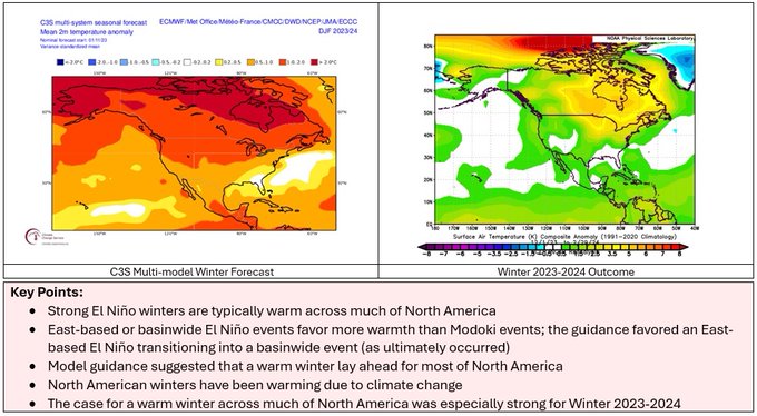
Early on, it was clear that he was going against the guidance when he called for a Modoki El Niño. No guidance showed a Modoki event.
From last year:
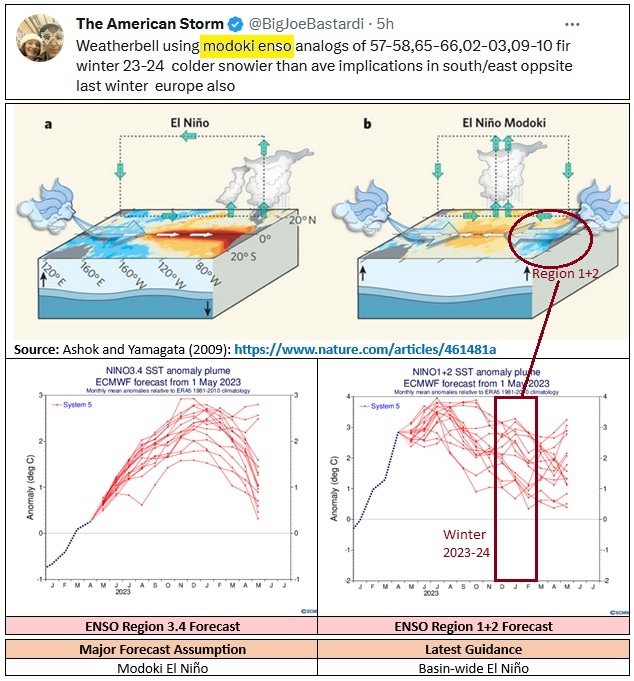
Forecast assumptions should be evidence-informed. Relying on evidence provides no guarantee of success given the limitations of long range guidance, but it gives one a better chance at verification. At the same time, one should have the courage to adjust the forecast when developments warrant adjustment rather than doubling down on one’s ideas. Further, one should avoid confirmation bias from only choosing guidance that agrees with one’s thinking, especially when such guidance is an outlier. Finally, the climate context matters. The shift in SSTAs, impact of ongoing marine heatwaves, smaller pool of deep cold, etc., render past analogs irrelevant unless they are adjusted.
In the end, the winter guidance was very accurate for North America.
Not only was he forecasting a Modoki Nino and using 57-58, 65-66, 02-03 and 09-10 as his analogs, he also said 76-77, 77-78 and 14-15 were analogs in the fall. Completely ludicrous and blatant wishcasting. Nothing, not one thing pointed to that at any point. It was delusional to suggest otherwise. He went completely off the rails AGAIN and simply found the coldest and snowiest El Niño/borderline El Niño winters for the east coast and said they were great analogs. In doing so he completely lost what very minimal credibility he still had left and made himself look like a total fool just to appease his east coast weenie base and get subscription money, likes, follows and retweets. It was utterly embarrassing but I don’t think he cared one bit
-
 2
2
-
-
14 minutes ago, MJO812 said:
AI took away the storm
I knew as soon as I saw JB hyping it, it was doomed. The guy is the kiss of death
-
1
-
 2
2
-
-
10 minutes ago, Brian5671 said:
Not sure what he's looking at. Canada is torched and the GFS is a torch outside of a day.
Assuming the Al is even correct, you won’t see snow outside of interior, elevated northern New England. It’s not even remotely cold enough here. Late March, spring climo FTW
-
12 hours ago, MJO812 said:
AI is consistent
Just more cold air we need
I'm tracking this

Yes!!! More rain!!! It’s over. Dead. Let it go.
Try again in 9 months when it’s December
-
 1
1
-
-
-
-
12 minutes ago, Ginx snewx said:
Joe made that map?
He’s hyping it on twitter
-
5 hours ago, MJO812 said:

Ok Joe Bastardi
-
20 minutes ago, Allsnow said:
I knew it was bad but didn’t realize it was that bad. I thought Boston had well over a foot right now
-
1 hour ago, MJO812 said:
Earthlight is on board
Not for NYC snow he’s not
-
3
-
-
1 hour ago, bluewave said:
It’s good to see AI versions of these models coming out. The hope is that they can correct the day 11-15 cold bias of all the major models. It will be interesting to see if AI can be used to correct the long range tendency for models to underestimate the warmer MJO forcing. That’s a big part of why the week 2 and beyond forecasts have been up to 5° too cold in spots going back to late November.


The severe cold and high latitude blocking bias the models have had since November has been mind blowing. Totally astonishing. Bust after bust after bust for the last 5 months in a row. Hard to believe actually. The busted digital snow fantasies in the long range have been equally as bad
-
Many stations from Newark to Boston had their lowest 2 year snowfall totals and averages on record. It’s a bit of a surprise this took so long to achieve with how warm the winters have been getting. Very little we can do when record warmth combines with a very hostile Pacific. Plus we did this with a La Niña last winter and El Niño this year. The SSWs and Atlantic blocking intervals this winter we’re no match for the warm MJO action. Same for the near record -AO in December 2022 and strong blocking pattern last March. The Pacific has just become to powerful a force in terms of flooding North America with warmth and producing unfavorable storm tracks.


In an absolutely shocking development:-
1
-
-
18 minutes ago, Stormlover74 said:
Now of course it will be right
Extremely unlikely that it is. Like winning the lottery odds of it being correct. It’s a game of how many times are people going to fall for it now.
Even if it was right, it’s late March at that point…..too little, too late
-
1
-
-
4 minutes ago, Brian5671 said:
It's weird that people still think it's actually going to get cold for more than a couple of days...this is like the 4th or 5th time around on this
The MJO is going to win, again. Hit the repeat button. It’s like the movie Groundhog Day. This has been happening with the long range models since November, phantom blocking mirages over and over again. “Fool me once, shame on you, fool me twice, shame on me”
-
1
-
2
-
-
Let’s see how long it takes the long range models to see the MJO this time and fold like an accordion lol We’ve seen this movie before and we know how it ends….
-
2
-
-
-
-
1
-
1
-
-
Beautiful warm March day! I was driving with the windows down blasting Van Halen’s Panama
 Spring has sprung! I feel like dancing
-
2
-
1
-
-
1 hour ago, donsutherland1 said:
It was. My point is that there was a large pool of cold air—actually frigid air—to be tapped. Through mid-March that does not appear likely to be the case.
Exactly, there is no cold air in Canada or the CONUS right through 3/15 and beyond. The Equinox is 3/19. Game over. Been game over, it’s time some folks accept reality and move on. We are beating a dead horse now. The fat lady has sung and gone home
-
 1
1
-
1
-
-
6 minutes ago, SJonesWX said:
please stop
He’s still going to be doing it in April. “Joe Bastardi said….”
-
15 minutes ago, MJO812 said:
White St Patrick's this year ?
That’s going to be a really good trick with zero cold air
-
Absolutely no GEPS ensemble support whatsoever for that extreme outlier operational CMC run
GFS: Nothing
GEFS: Nothing
ICON: Nothing
EURO: Nothing
EPS: Nothing
UKMET: Nothing
NWS Blend of Models: Nothing-
1
-
-
2 minutes ago, ag3 said:
Stunning day. 10 out of 10. Can’t get better.
Already 58 degrees under bright sunshine.
Temps will bust to the high side for sure today.
Next Sunday is going to be amazing. After 7pm sunsets come back
-
2
-
1
-
1
-
-
5 minutes ago, Brian5671 said:
Overnight runs very wet for the next week-CMC the wettest but others are very wet as well

It’s been an epic deluge for our area from October till now with very few breaks in between


March 2024 disco/obs
in New England
Posted
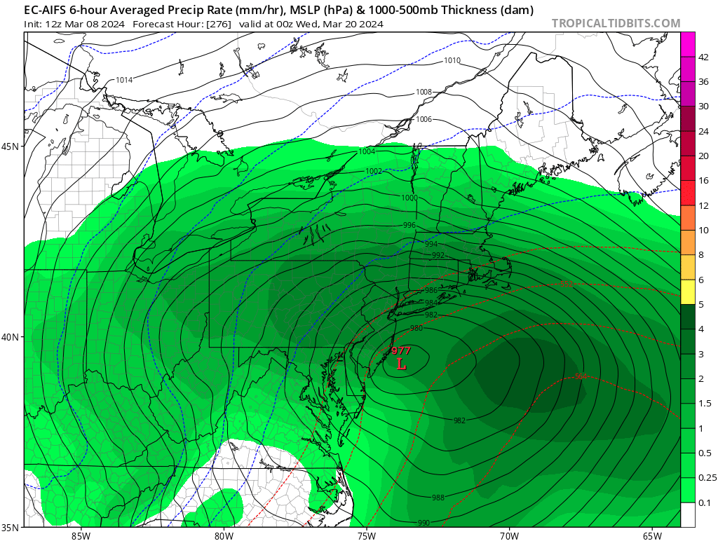
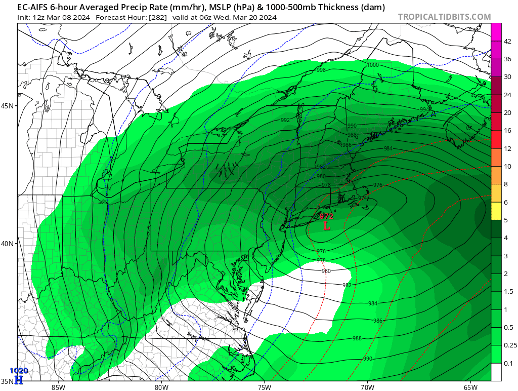
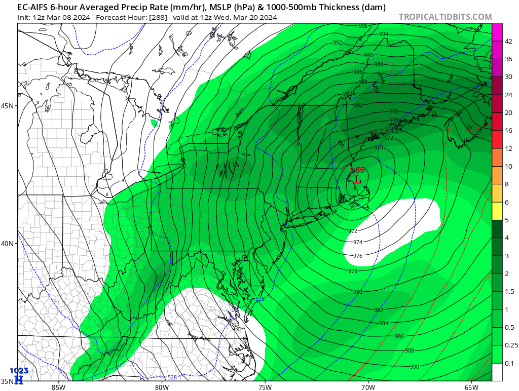
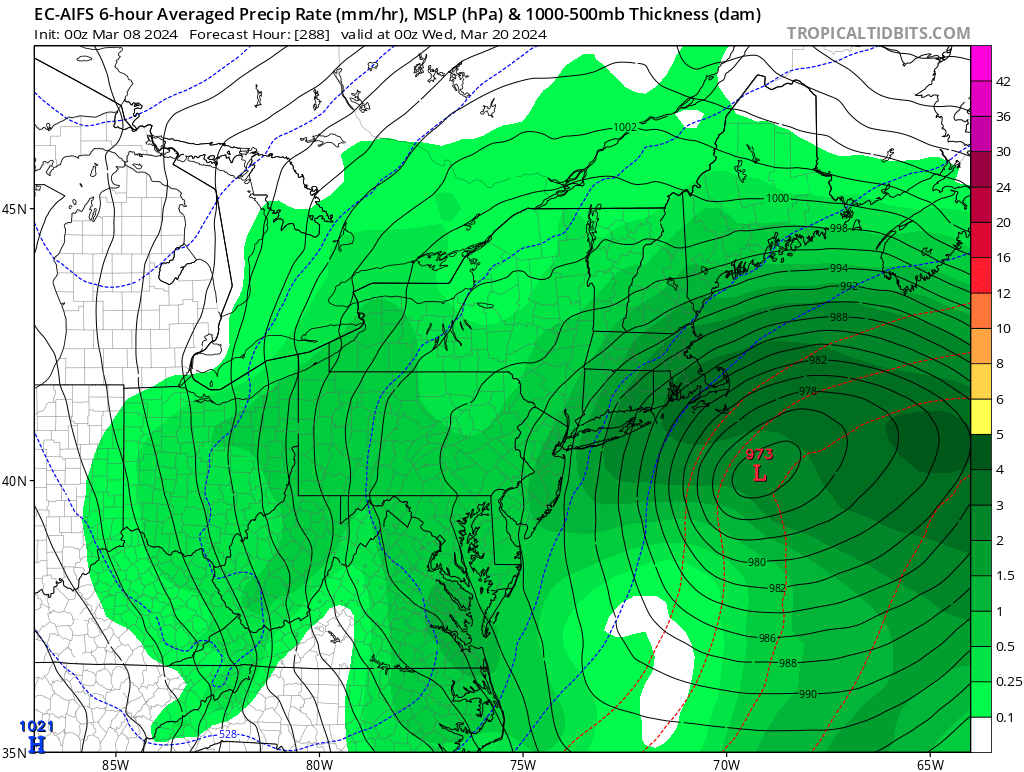
More digital day 10+ snow on the operational GFS. Lol