

snowman19
-
Posts
7,400 -
Joined
Content Type
Profiles
Blogs
Forums
American Weather
Media Demo
Store
Gallery
Posts posted by snowman19
-
-
40 minutes ago, bluewave said:
My guess is that this persistent trough near the Northeast is related to the +IOD creating a MJO 2 type pattern.


If the models are overdoing this +IOD event, which is possible and we go into a -IOD, I think this La Niña explosively develops this summer and fall, should that happen, there’s a chance it becomes a record event (i.e. 73-74, 88-89). The ingredients, both atmospheric and oceanic are definitely there
-
 3
3
-
-
@bluewave @donsutherland1 Looks like we hit the peak of this overperforming solar maximum cycle around October, sunspots maxing out. Looks to be a high solar/high geomag winter coming up, effects TBD….
-
1
-
-
1 minute ago, Allsnow said:
Yup. Muggy morning. Taste of things to come
It feels like the middle of May this morning. And yea a taste of things to come. All the soil moisture evaporating out and doing its dirty work. We are in for a very humid and very hot summer IMO
-
1
-
 1
1
-
-
@Bluewave
Growing support for east-west tracks and not recurving hurricanes/tropical storms. Haven’t seen that in awhile-
 1
1
-
-
30 minutes ago, psv88 said:
Not sure why it matters that the warming may be largely from lows. Warmer is warmer. High lows means fewer mornings with frosts and freezes that kill bugs. One could argue that higher lows has more of an impact on that environment than higher highs
The peepers have been out at night since mid-March. This was the earliest I can ever remember that
-
1
-
-
1 minute ago, Stormlover74 said:
Euro a deluge now
.thumb.png.ffba45afbc78c74104f50b427f2086d1.png)
Nice! 1-2 more inches of rain between now and Sunday. Just what we need….
-
 3
3
-
-
The Euro has a MJO 2,+IOD ,La Niña, record Atlantic SST summer with a ridge over the Rockies and Northeast undercut by a trough to our SW. So above average temperatures, dewpoints, and rainfall. The MJO 2 is also very active for tropical storms and hurricanes.


The models are also predicting a flip to a +PMM, which when combined with a +AMO/Nina/+IOD is HIGHLY supportive of a hyper active Atlantic hurricane season-
4
-
-
1 hour ago, bluewave said:
The updated information incorporating a possible +IOD and La Niña with record Atlantic SSTs shows how active the hurricane season can be if all the pieces come together.
Saw that. My question is does that rare +IOD/Nina combo continue through fall? My guess is no
-
15 hours ago, donsutherland1 said:
This is likely a key point if one is looking far ahead to next winter. The balance of early odds seems to favor another warm winter with low snowfall, but skill this far out is essentially non-existent.
Just a very, very early preliminary look (which means nothing at this point), would seemingly support a La Niña, orientation and strength to be determined, +QBO, -PDO, maybe neutral to negative IOD come fall?, +AMO, high solar/high geomag. Snow cover and ice cover to be determined in the fall
-
1
-
-
I suspect areas of metro see 80’s next week. Very likely more than once too
-
3
-
1
-
 2
2
-
-
11 minutes ago, bluewave said:
Good question since we usually don’t see record SSTs in the NW Indian Ocean and a +IOD during developing La Ninas.
Yea and I suspect the developing Nina only serves to reinforce the -PDO
-
2
-
-
28 minutes ago, bluewave said:
Yeah, it’s a nice improvement on next weeks forecast from a week ago.
New run

Old run

Do you think we keep the very unusual +IOD/La Niña through the fall or do you think it goes at least neutral? Although it’s possible, my guess is that we go at least neutral IOD by fall and possibly -IOD during the fall
-
1 hour ago, MJO812 said:
High around 80 today
Not hard to do now, we have a late August sun overhead
-
1
-
-
Very confident we see our 1st 80+ degree high temp in the metro area since October by the end of this month
-
1
-
1
-
1
-
-
18 minutes ago, JetsPens87 said:
Yea.. its April. I struggle to find a correlation between OP Gfs in early April and the entire summer.
When you look at the synoptic picture (rapidly developing La Niña, -PDO, ++AMO) that actually points to anything but a cool summer, actually points to a SE ridge on roids summer. The high soil moisture does point to wet/humid
-
2
-
-
1 hour ago, LibertyBell said:
2010 was amazing with a west to northwesterly flow for most of the summer.
dry and hot, low humidity and no flooding rains.
Hot is an understatement. Yes it was dry but boy was 2010 a torch summer
-
2
-
-
39 minutes ago, bluewave said:
Yeah, a few showers on Wednesday as the warm front comes north. Then the heavier rains with embedded convection from Thursday into Friday with more 50+ mph gusts. The low pulls away on Saturday with more strong NW winds gusting over 30 mph.


Thursday night into Friday morning looks nasty, very heavy rain, high winds. What else is new? The beat goes on
-
2
-
2
-
-
1 hour ago, uofmiami said:
It was brutal yesterday evening and this morning for it. My son’s team as least won one game. Tomorrow morning is 3rd game of weekend tournament at 8:45. Going to be another miserable day for baseball.
The high school teams here always play their first game the last week of March and without fail it’s always chilly and miserable. My cousin’s little league season started today and it sucked, way too cool but that’s baseball in the northeast I guess
-
1
-
-
17 minutes ago, Brian5671 said:
Massive cutter. But with the blocking breaking down I doubt it's 3 days
There’s no high latitude blocking to slow it down. Hard sell on 3 days of rain
-
1
-
-
1 hour ago, bluewave said:
Tuesday looks like our next 70s day of the spring before we get backdoored on Wednesday. Then our next slow moving storm system with more heavy rains and high winds from Wednesday into Friday. That MJO 8 and -NAO combo last few weeks is really having a lasting influence. I guess if we keep finding ways to avoid the MJO 8 in the winter like recent years it will catch up with us in the spring.


This wet pattern we’ve been in since the end of the last drought in 2002 can’t continue forever. Law of averages, eventually this cycle has to end, it’s astonishing that its even lasted 22 years
-
2
-
-
8 minutes ago, Allsnow said:
At least back in 2011 we knew we were f***ed once that huge Bering Sea vortex showed up a few days after Thanksgiving. It became a semi-permanent feature that winter and the +EPO floodgates were wide open from the end of November right through the beginning of April
-
1
-
-
12 minutes ago, BucksCO_PA said:
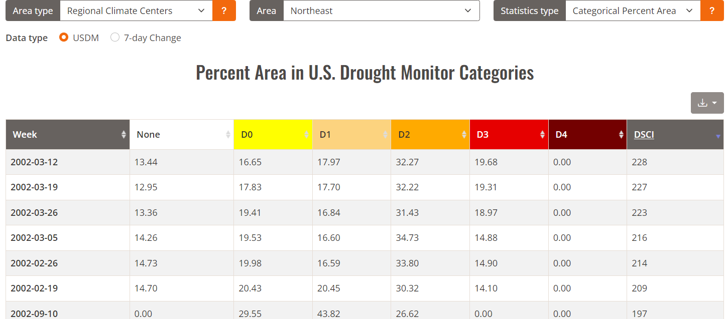
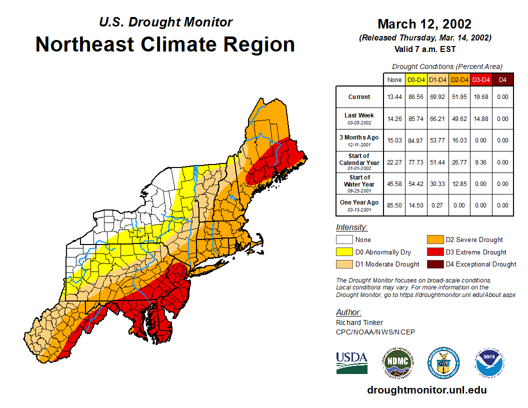
For the Delaware River Basin we haven't had a true drought since 2002. By true drought I mean from a hydrological standpoint. The last drought warning / emergency ended in NOV 2002. The highest weekly drought severity indexes for the NE back to 12/2000 were during the 2002 drought peaking on 3/12/2002 with an index of 228. For a frame of reference the fall 2016 dry period peaked at 161, fall 2020 at 131 & the summer 2023 dry period topped off at 107.
Since 2002 dry periods have been rare & when they happen they don't have a long shelf life.
https://droughtmonitor.unl.edu/DmData/DataTables.aspx


It’s hard to believe that the last true drought emergency we had in the metro area was over 22 years ago (2002). The drought/wet cycles don’t normally run this long
-
1
-
-
1 minute ago, bluewave said:
The statistical predictors based on record SSTs and La Niña are very impressive for the coming hurricane season.
A very dangerous picture is getting painted for this upcoming Atlantic hurricane season. All the indicators right now are pointing to a record breaking season and have been since March….
-
2
-
-
1 hour ago, Brian5671 said:
you would think some would learn-a ratter winter is a ratter winter...what can go wrong will. And where's the cold air? there's zero cold except way north and at elevation.
The only one (besides people who aren’t mets) who was hyping an I-95 corridor snowstorm for this week was JB. He was also suggesting that April, 1982 was a good match. Not surprising coming from him though. He’s been completely off the rails since November


.png.66e20a7a94f7c49ea50fdadc3f27307d.png)


April 2024
in New York City Metro
Posted
This *could* potentially have big stratospheric implications….major tropical volcanic eruption ongoing. If this thing pumps enough sulfate aerosols into the stratosphere, it could conceivably have effects on next winter’s SPV and NAM (AO) state. This needs to be followed closely @Volcanic Winter…