Rittenhouse
Members-
Posts
271 -
Joined
-
Last visited
Content Type
Profiles
Blogs
Forums
American Weather
Media Demo
Store
Gallery
Everything posted by Rittenhouse
-
Jan 24-26 Weekend Snow and Sleetfest Model Thread Part Tres
Rittenhouse replied to H2O's topic in Mid Atlantic
NAM is a bust for DC: a few hours of snow, followed by a brief period of heavy sleet, then several hours of light sleet and freezing drizzle. North of I-70 around Frederick, where the deformation axis sets up, does okay. I think the heavy precip will partly compensate for the warm nose there. I'd caution against looking too closely at the colors on the simulated radar. For some, the changeover will be slower than the models are showing. It will come down to band placement. However, since the NAM is better at detecting these features, there is a high bust potential for DC right now. I think the GFS snow totals are likely on the high end for the coastal plain. -
From the NWS discussion: I performed a cursory analysis of current conditions this morning and I found that temps are running a few degrees cooler than forecast with dewpoints in the single digits. Up stream observations in NC and southern VA suggests that snow is over performing. I have adjusted my snow ratios this morning to account for the well below freezing layer ahead of the precipitation which should allow for higher snow rates. Initial onset of precipitation is on track this morning and snow should fluffy to start before switching over to wet snow as the layer starts to warm and transitions over to a wintry mix for most areas along and east of I-81. I will continue to monitor current conditions to see if I need to up snow totals. It wouldn`t surprise me if we get higher snow totals further eastward than expected due to extremely cool air mass ahead of this system.
-
- 1,932 replies
-
- 4
-

-
- heavy snow
- wind damage
-
(and 1 more)
Tagged with:
-
Had no idea that 12"+ snowfalls were that unusual. Seems like we have one every couple of years or so these days.
- 2,426 replies
-
- heavy snow
- ice pellets
-
(and 3 more)
Tagged with:
-
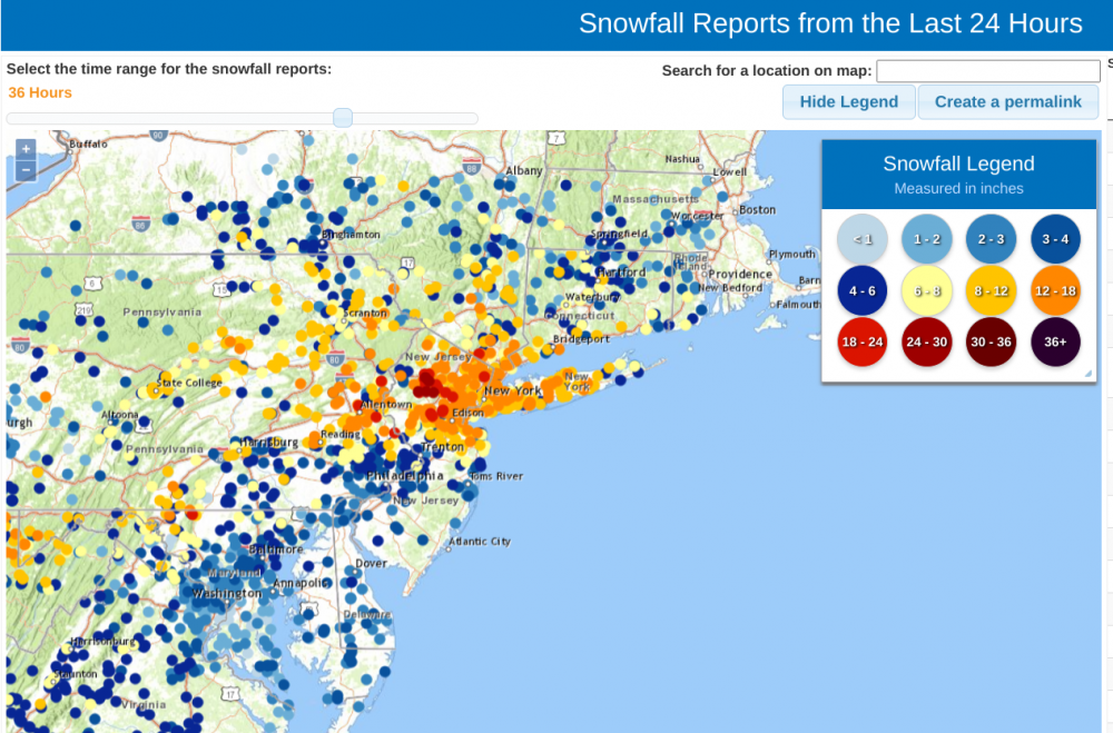
NYC closing in on a foot... PRELIMINARY LOCAL STORM REPORT NATIONAL WEATHER SERVICE NEW YORK NY 1044 AM EST MON FEB 1 2021 ..TIME... ...EVENT... ...CITY LOCATION... ...LAT.LON... ..DATE... ....MAG.... ..COUNTY LOCATION..ST.. ...SOURCE.... ..REMARKS.. 1030 AM HEAVY SNOW CARROLL GARDENS 40.68N 74.00W 02/01/2021 M9.5 INCH KINGS NY TRAINED SPOTTER
- 1,932 replies
-
- 2
-

-
- heavy snow
- wind damage
-
(and 1 more)
Tagged with:
-
The models seem to underestimate overrunning/front-end snows but overestimate back-end snows for NYC. Not sure the science behind it.
- 2,426 replies
-
- 3
-

-
- heavy snow
- ice pellets
-
(and 3 more)
Tagged with:
-
Upton explaining why they didn't issue blizzard warnings: For coastal areas, winds 20-40 mph with gusts 40-60 mph will help create near-blizzard to blizzard conditions from roughly mid-morning into the afternoon, possibly even into the evening. Working against this however is that an elevated warm nose then likely pushes into much of Long Island and SE CT, possibly even into the city as well. This then introduces mixed precipitation for these locations, with even a complete changeover to rain across the Twin Forks and potentially even coastal SE CT with the help of boundary layer temperatures and the warming aloft. Do not have enough confidence of 3 hours of blizzard conditions to go with a blizzard warning - whether it be due to uncertainty of PCPN type or winds being consistently strong enough while it`s snowing. There is still a potential that some areas get converted to a blizzard warning if confidence increases. The strongest frontogenesis is likely to the north of these areas in the evening, so dynamic cooling won`t be much of a factor for much of the forecast area at this point. The city, especially LGA, probably has the best chance for blizzard conditions, being less likely to mix while still being close enough to the coast for the winds.
- 2,426 replies
-
- 2
-

-

-
- heavy snow
- ice pellets
-
(and 3 more)
Tagged with:
-
December 16-17, 2020 Storm Observations and Nowcast
Rittenhouse replied to wdrag's topic in New York City Metro
I don't think Central Park ever reported sleet. The totals were kept down in the NYC metro due to dry slotting, not mixing. The best bands set up to the north and west of the area. This was clearly shown by the NAM before the storm.- 1,011 replies
-
- heavy snow
- sleet
-
(and 4 more)
Tagged with:
-
December 16-17, 2020 Storm Observations and Nowcast
Rittenhouse replied to wdrag's topic in New York City Metro
This system stretches all the way into the Gulf of Mexico to the Yucatan.- 1,011 replies
-
- heavy snow
- sleet
-
(and 4 more)
Tagged with:
-
December 16-17, 2020 Storm Observations and Nowcast
Rittenhouse replied to wdrag's topic in New York City Metro
Eye-like feature developed this morning.- 1,011 replies
-
- 5
-

-
- heavy snow
- sleet
-
(and 4 more)
Tagged with:
-
December 16-17, 2020 Storm Observations and Nowcast
Rittenhouse replied to wdrag's topic in New York City Metro
Manhattan Mesonet station (UES) reported a 40mph gust at 6:45pm.- 1,011 replies
-
- heavy snow
- sleet
-
(and 4 more)
Tagged with:
-
December 16-17, 2020 Storm Observations and Nowcast
Rittenhouse replied to wdrag's topic in New York City Metro
Winds picking up: LGA reporting sustained winds of 28 mph, gusting to 35 mph.- 1,011 replies
-
- heavy snow
- sleet
-
(and 4 more)
Tagged with:
-
The initial band is impressive. All of that should fall as snow even at the coast. The mixing showed on the NAM occurs after the initial band, during the dry slotting.
- 3,762 replies
-
- heavy snow
- heavy rain
-
(and 3 more)
Tagged with:
-
The low dew points this morning indicate the strength of the cold air mass in place. Stronger high = less chance for mixing.
- 3,762 replies
-
- heavy snow
- heavy rain
-
(and 3 more)
Tagged with:
-
Dew points this morning were impressive: 2 degrees in Central Park, 6 degrees at JFK. As Bernie Rayno pointed out, this suggests that there will be less mixing in the city.
- 3,762 replies
-
- 1
-

-
- heavy snow
- heavy rain
-
(and 3 more)
Tagged with:
-
As you can see in that snow map, western suburbs of DC do alright. Dulles Airport averages about as much snow as NYC.
- 3,762 replies
-
- 1
-

-
- heavy snow
- heavy rain
-
(and 3 more)
Tagged with:
-
remnants of zeta and potential first flakes for some areas
Rittenhouse replied to forkyfork's topic in New York City Metro
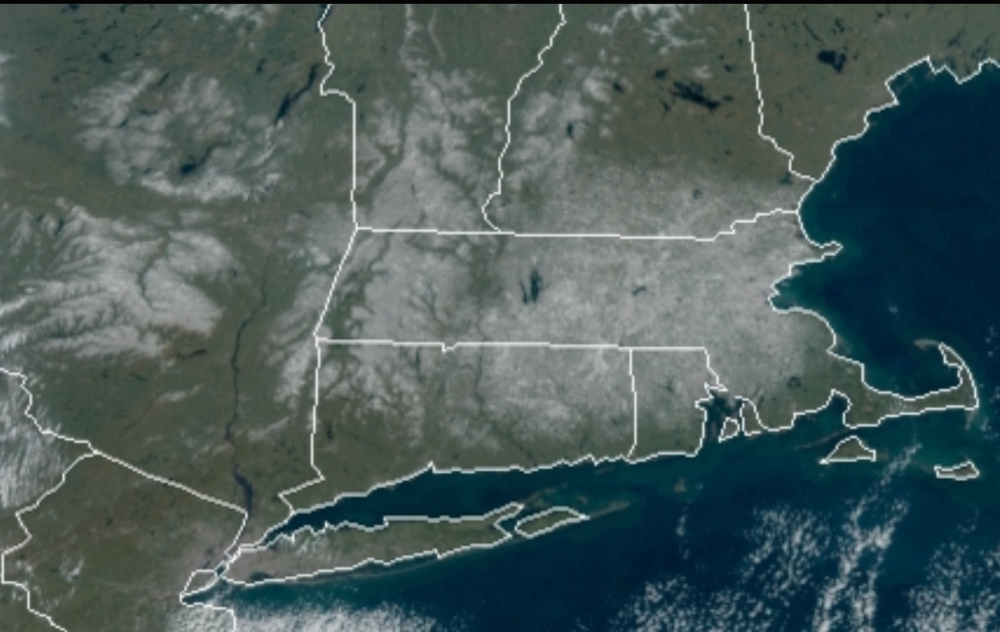
The satellite this morning is fun to look at. You can see clearly how elevation dependent this event was for the Hudson Valley.


