

Blizzard of 93
-
Posts
9,995 -
Joined
-
Last visited
Content Type
Profiles
Blogs
Forums
American Weather
Media Demo
Store
Gallery
Posts posted by Blizzard of 93
-
-
Patience everyone....patience.
I think we will be talking about storms & rumors of snow storms before too long!
Trust in the Euro weeklies & good seasonal models that have advertised a good looking winter pattern for the middle of January right through March.
Our time will come soon!
-
3 minutes ago, sauss06 said:
are we brothers from another motha?
Listening to this rain pound
 on the roof of work, i can't help but wonder...........................what if
Yes indeed!
We just need a little patience, just like that song from the 80’s !
-
 1
1
-
-
35 minutes ago, pasnownut said:
absolutely. You were not the only one. We are a unique bunch, but I consider myself to be in great company.
I had a NOAA weather radio. Every day in the winter after school, I could not wait until they updated the forecast in the late afternoon. The best times took place when the alerts for a “Winter Storm Warning” were broadcast. I would listen to it over & over !
In the 80’s & 90’s,in the days before the internet, all that we had for weather news was the weather radio, local TV weather, The Weather Channel & Weather World on PBS. I would try to flip around during the 6pm or 11pm TV news to catch every forecast possible during winter!
-
2
-
-
9 minutes ago, MAG5035 said:
I do understand where your coming from and I'm certainly not disagreeing that this has been a lousy month snow-wise. Back this way this month has accounted for only about an inch or so of the 13.5" I have to date when Dec generally averages roughly 8-10" here. It's been a tough month, we had a cold pattern for most of the first half of the month and missed out on a suppressed storm near mid month before the pattern switched in favor of cutting storms. We have not had any established blocking downstream to promote any consistent NW flow to promote very much snow in the LES belts or mountains either. We're just working through a period right now that has featured an unfavorable storm track but not necessarily a warm regime either, which I went into my thoughts on that in my previous post.
In the case of MDT I just think the difference between a T for the month and 0" is a fairly moot point. It was noted in that CTP discussion I posted that "any flurries count as a trace of snow". A T for the month would still imply there wasn't any measurable snow for that month. This current December is probably going to close out with zero snowfall in MDT if there hasn't been a T recorded to this point. So yea either way we're pretty much on level footing in that regard to 2015 and 11 other Decembers.
I'm more interested in the details that got us there. I mean look at those temperatures in that period of Dec 2015 you posted. You could probably put those numbers in for the last 20 days of October and still end up above average. The warmth in that December (and November) was unbelievable. I actually am surprised there was any snow recorded, and look at the temps during those days a T was recorded. But there is no comparison to this December temp wise. The temperatures for the most part this month have been typical of the month we're in aside from the couple warm days we've had ahead of cutting storms, but we have not been in any established warm pattern. If we're talking pretty unprecedented runs without meaningful snowfall, there have been a couple winters in the recent past where we've went way into January before some LSV sites ever even had their first measurable snowfall. Take that 2015-2016 for example with the T in December, MDT didn't have their first inch until January 22-23rd (which was immediately followed by about 30" or so more). 2006-2007 was another winter that had an absolutely awful start in the LSV. I'm pretty sure York/Lancaster didn't record their first inch of snowfall until early February of that winter. MDT might not have either, check out the graph. So moral of the story, yea this has been a lousy month but I can show you worse periods of no snow..and pretty recently too haha. And MDT is already 8.8" on the season because of November's snowstorm, which still would have them above average.
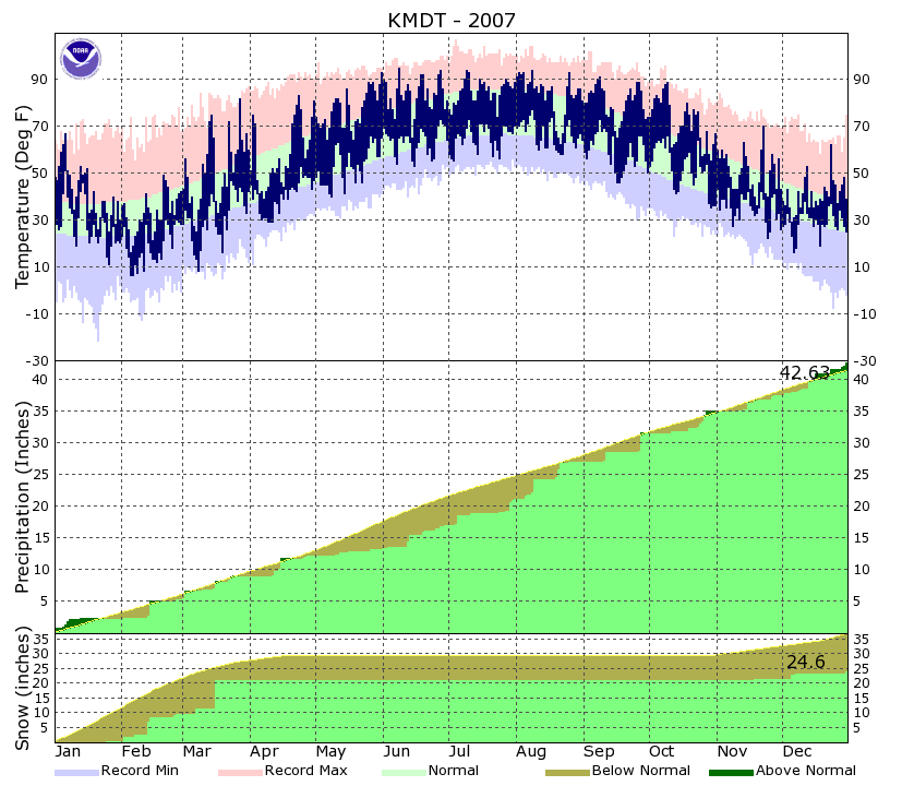
You can find these climo graphs HERE and they go back to 1999 for MDT.
Great post MAG !
I think that in a few weeks our snowless December will be a distant memory !
The Euro weeklies released today look outstanding in terms of good winter storm pattern potential from mid January through the end of the run in early February.
I think there will even be snow chances in the next week or so, even before the advertised “good” pattern arrives.
-
The 18z GEFS also delivered some Christmas cheer with its best run in a long time. The mean snow amount this run for the LSV is 5 to 6 inches. Every GEFS ensemble member, except for 1, brings at least a few inches of snow to CTP through the end of the 16 day run. Ensemble Member E8 would be nice !


-
The 12z EPS run today was the best in the last couple of days. We should have a few snow opportunities starting with this weekend & continuing through the first week of January.
About 35 of the 50 EPS ensemble members brought at least a couple of inches of snow to CTP. There were several members that were heavy hitters.
We should have a fun week of tracking!

-
I got the Kocin-Uccellini -KU -
Northeast Snowstorm books for Christmas!!!
I have wanted these for years !
Hopefully we get another 1 or 3 legendary storms to add to the book this year !

-
2
-
-
All I want for Christmas is for this 0z Euro Control run from last night to verify!

-
Merry Christmas to all !
-
27 minutes ago, Itstrainingtime said:
Reading Horst's latest discussion this afternoon, he is calling for a wild and active January with lots of...rain and some snow. While there might be a 4-7 day period of cold, wintery weather he doesn't see winter locking in through the month.
Merry Christmas to each of you. Enjoy this special season and let's get ready for what we do best...more rain later this week!
")
Every good seasonal model & most long range pro forecasters have very much above average snow & cold for the rest of this season.
-
Very Light flurries now in Marysville !
-
The 12z GFS delivered 2 nice Christmas presents with snow events for CTP for this Sunday & again on New Year’s Day into the 2nd day of January.
The maps below show the 2 events & then the first storm individual total & also the 2 event combined total.


-
Thanks to the 8.8 inches of snow in November at MDT, Harrisburg is above normal snow for the season to date.
According to CTP’s daily summary, MDT only averages 4.1 inches of snow through December 23rd.
Even if it doesn’t snow until the first week of January & beyond, Harrisburg will still be in good shape to have another chance at an above average snowfall season.
-
5 hours ago, canderson said:
Hope we score the first week of January cause if not we are in for a long snow drought
If we don’t score the first week of January, the potential pattern should get even better toward mid January & onward according to just about every long range & seasonal model.
Anyway, We should have chances at snow by the first week of January.
-
7 minutes ago, bubbler86 said:
For the area below the turnpike it is fairly warm at the moment, with cloud cover already setting in, to hope for accumulating snow tonight. Upper 40's at most stations. Dec may end up close to 5 degrees above normal at this rate if we get another late week torch next week.
The first half of December was below normal.
The second half of November was way below normal.
-
I don’t think it will take a miracle....
The 12z Euro does show the snow north of the LSV, however the precip max again is over the LSV to the Lehigh Valley. Most of the precip falls after dark into 850 temperature air of less than -3.
I think some of us could see the car tops & grassy surfaces covered.


-
The differences between CTP & Mt. Holly are a little interesting along the border of the forecast offices.


-
For tonight’s Christmas Eve Eve event, The 12z NAM ‘s brought better precip down to the I-81 corridor of the LSV & were also are slightly colder than recent runs.


-
The latest GEFS run today continues to look good for snow chances for CTP.
Most of the snow on this run arrives between New Year’s Eve & the first week of January.


-
Thanks for getting this started!
Here is some good news to start this thread. The 12z GFS gives us 2 snow storms. The first one arrives for New Year’s Eve & drops 3-4 inches of snow for CTP. The second one arrives on January 2nd & puts down another 2 or 3 inches of snow.
This would be a great way to ring in the New Year!

-
1
-
-
1 hour ago, pasnownut said:
its just been one of those years.
We need to change the momentum in here.
The thread title still says “ Fall “ , but we are now in winter !
Maybe that will get things going in here & get @pasnownut to start getting more excited when I post snow maps overnight ?
-
The period from New Year’s weekend to the first week of January look to be very active with a few winter storm chances. The general theme looks to be cold air pushing the boundary south of PA, with Lows then riding up the coast that deliver the snow to CTP.
The Euro & GFS Ops & the ensembles are saying that we will be very busy here next week!
All that I want for Christmas is for this Euro Control run to verily!


-
1
-
-
5 hours ago, MAG5035 said:
Update: changeover here now, a merciful end to another miserable rainstorm in a year that's had enough of them. The warmth for the day was kind of nice actually, it really hasn't been all that warm at all this month for the most part.
The very warm day will be brief and modeling is starting to pick up more on this potential Christmas Eve mischief (looking more towards Christmas Eve..Eve). Now showing more on the GFS and the NAM at range is seeing it. New 0z NAM run had a 1-3" type event in central and eastern (Harrisburg and above generally in the LSV). Probably going to be a weak event but it represents a shot a perhaps a white Christmas over at least a portion of the subforum. This is of the variety that would favor the western mountains and some central areas but a slightly more robust system could run a swath across all of PA.
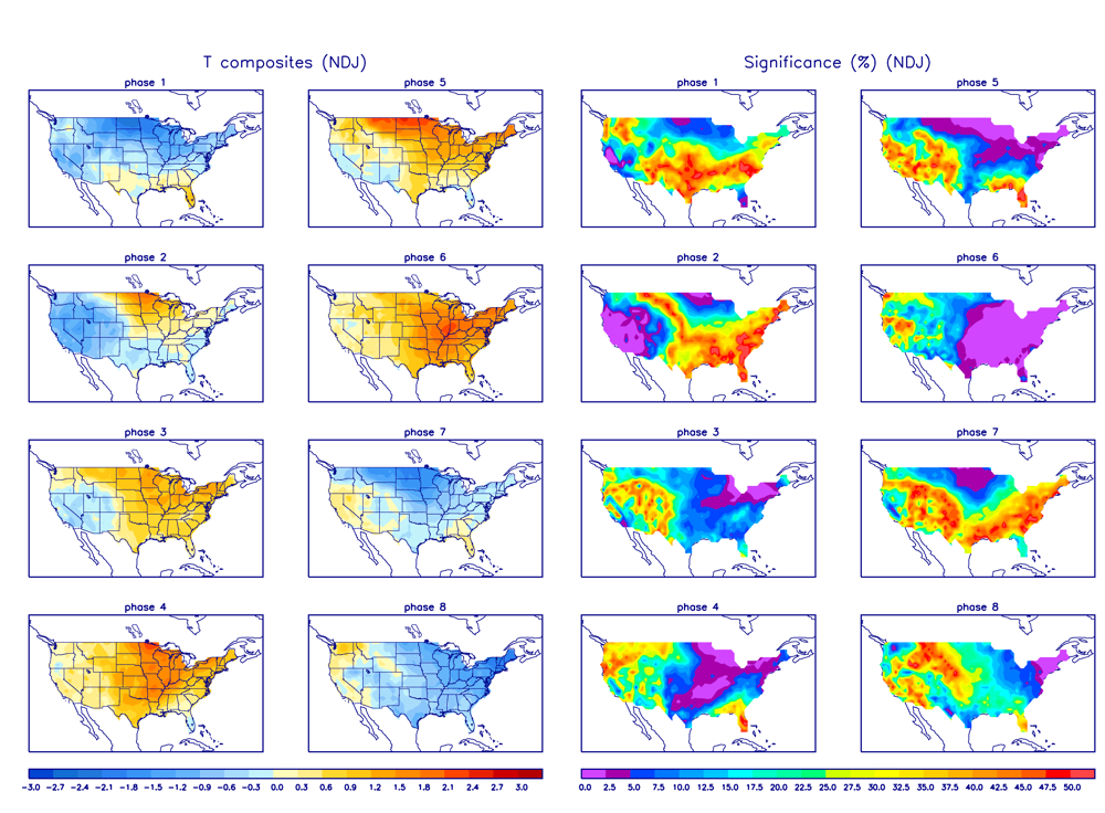
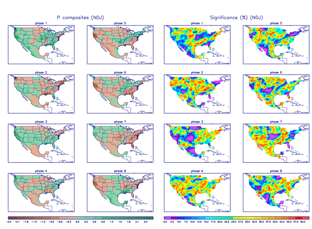
Beyond that, it appears we're set to endure another cutting storm in the between Xmas and New Years window after having seasonal cold. It hasn't been an issue of temps so much as unfavorable storm tracks this month. We unfortunately missed the one to the south mid-month that would have made for the rout being on in terms of tracking towards an above average snowy winter. Been looking at teleconnections and NAO/PNA/EPO don't really show anything to me extremely clear cut. the -NAO is somewhat negative (okay), PNA going negative (indicating western troughing) and EPO somewhat positive (meh). The one thing I see in the teleconnection realm is we are pretty solidly into phase 5 in the MJO... which in NDJ,DJF, and JFM indicates one of the strongest correlated signals to eastern warmth and SE ridging. I actually think it fits fairly well right now if you look at the maps pertaining to this phase (Temp and Precip). It obviously hasn't been particularly warm, but the last couple events have featured unfavorable tracks and rain for the region. I think once we cycle towards more favorable phases we could see a better alignment for potential snow events. I remain fairly optimistic of things once get into the thick of winter (Jan/Feb) if we continue to have an active pattern (esp southern stream). I definitely foresee opportunities.
The 0z NAM does like the idea of a little early Christmas Eve snow !


-
The Euro weeklies look amazing beginning in early January!
Game on !!!


Central PA - Winter 2018-19
in Upstate New York/Pennsylvania
Posted
Yes, I hope we score some snow before mid January too.
The January 3rd/4th possibility is not dead yet & there is another chance on the 8th or 9th as well.
If not, maybe this will be like the winter of 2014-2015, where we didn’t get much snow before January 20th that year. Then we had a good pattern of snow from late January through the middle of March that took MDT to an above average snow season of 39 inches.
This year, at least we are still running above normal snow to date thanks to our November 8.8 inch snowfall.