

Blizzard of 93
-
Posts
11,782 -
Joined
-
Last visited
Content Type
Profiles
Blogs
Forums
American Weather
Media Demo
Store
Gallery
Posts posted by Blizzard of 93
-
-
51 minutes ago, Blizzard of 93 said:
No need to apologize...
The 12z Euro & EPS said that we should buckle up for a very busy winter storm week next week!
The 12z EPS still likes the idea of the early next week low tracking to the Ohio Valley & then transferring off of the Mid Atlantic coast.


-
3 hours ago, paweather said:
JB hyped it, I should not have posted that. Sorry forum I may have jinxed next week.

No need to apologize...
The 12z Euro & EPS said that we should buckle up for a very busy winter storm week next week!
-
 1
1
-
-
1 hour ago, MAG5035 said:
This shortwave passage has been pretty decent overnight here, just measured 1.6" and still working some bands of snow showers. 31ºF
There was a dusting of snow overnight here in Marysville.
It looks like another snow shower might make it here within the hour.
-
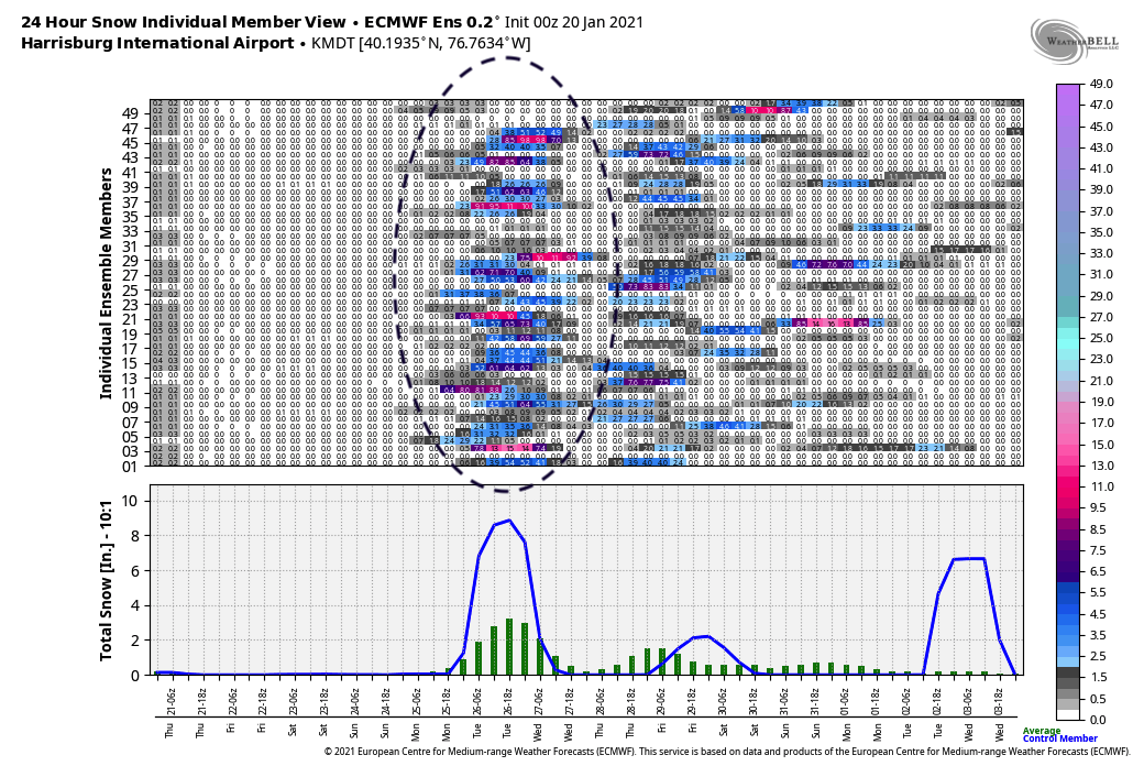
The 15 day 0z EPS snow map still looks good for chances beyond the early week threat.

-
2
-
-
2 hours ago, MAG5035 said:
The 0z Euro was a heartbreaker tonight, skirting the southern tier with decent snow while having a major cutoff and a majority of the subforum area mostly dry (Mid-Atl storm). However Euro ensemble mean and control run looked much better for us and got most into some snows. Looked similar to the Canadian maybe a bit further north with extent. GFS and its ensembles are now on their own currently with cutting as far north as it does making for a mix. Meanwhile it looks like the Euro ensemble is solidifying a nice mean with a majority of members showing decent snows at most of our local stations now. Track is key, because if this does go south and not pull off what the GFS is trying to do, we're probably going to have to contend with a sharp cutoff on the northern extent of the precip somewhere.
Harrisburg:
It’s good to see the EPS continue to be on board for the storm chance next week. There are are several ensemble members that target CTP.
I would sign up for the 0z Euro Control run.

-
1
-
-
I would sign up for the 0z Canadian for early next week.


-
2
-
-
I am gaining confidence for next week because all of the models today showed us getting some snow in the same time period. It is not the case of one random run by one model.
Like @pasnownut said, a few more runs and I will be excited. Hopefully we get to the point where the main question is not if we get snow, but how much!
-
6 minutes ago, pasnownut said:
Yeah Mag the nooners were looking like a few chances at scoring with the block doing what it should and forcing systems under us. Need NAO to stay west based or systems might cut to friggin Idaho.
If we can see more consensus build in the next few runs I’m going to get excited. As crazy as it is the euro is far enough south that we could have suppression depression for the Mon Tues system. As a result The next 2 might have a chance to gain latitude and get us in the goods. If that’s not enough we all remember how excited we were a week ago for this week and the snow shredder NAO tore em up. As the MA forum often complains ...many ways to fail. I’m not Debbyin just trying to keep it real in here. I want blizz’s maps to work as much as anyone here....and my snowmobiles...want it more.Next week is our best chance since the December blockbuster snow event.
We have multiple opportunities. I feel really good that we will score at least once. If all goes well, then we might get hit twice with snow!
-
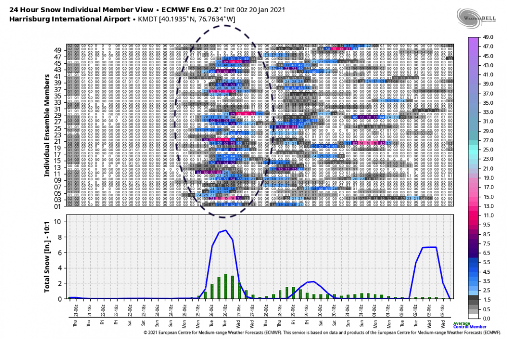
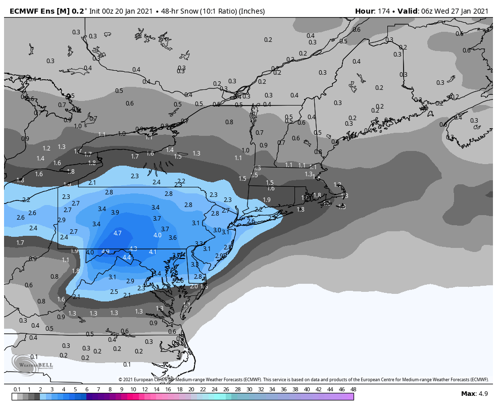
The maps above are the 12z EPS through next Friday morning and then the combined amount through the end of the 15 day run.
I like where we are sitting now in CTP!
-
-
4 hours ago, MAG5035 said:
Boy it's quiet in here for what looked like a half decent 12z suite today. Models seem to be showing more muscle with the blocking and could be two different events as well. Starting to look like more of a tighter situation of getting somewhere in between too much block (suppressed) vs bringing the low up enough to force mixing before the blocking sends it east or even ESE. The most mixy of the bunch which was the GFS today still had a majority of the region having a sizable part of the storm as snow as the block forces the low under and changes the initial ice to snow as deeper cold gets drawn south. Then had a decent snow event regionwide with the following wave.
The 12z models today were fantastic today with multiple snow chances next week. There could be the opportunity for the rare “snow on snow” next week.
There was good consensus at 12z today among the Euro, GFS & Canadian. Here are their snow maps through next Friday morning.


-
The 0z EPS agrees with the Op Euro with multiple winter storm threats over the next 10 days to 2 weeks for CTP.


-
The 0z Euro provided 2 Winter Storm chances for next week.
For the early week storm, It wouldn’t take much of a shift to the south with the storm track to give a mostly snow event to our southern tier. As it stands with this run, it would be mostly snow for the northern half of CTP. The southern half of CTP would have a heavy mix changing to snow as the low transfers off of the coast.The next threat is incoming next Thursday night into Friday at the end of the ten day run. It would have been nice to see the next 6 to 12 hours!


-
The overall 15 day EPS snow map is absolutely the best that we have seen this season since before the December event!
Could we get the elusive chance of snow on snow?

-
1
-
-
The 12z EPS then has another snow window of opportunity later next week into the end the month.

-
The 12z EPS today was a great run with multiple winter storm chances over the next 2 weeks.
The first chance is the early next week storm. The EPS still has the mean low track to the Ohio Valley with a transfer to the Mid Atlantic coast.
Here is the 3 day EPS snow map, which is very nice for that window.


-
The 6z Para GFS also looks good for the possible event early next week. It does not cut the low into the lakes.


-
The 0z EPS still looks good for the early next week winter storm chance. The mean still has the general idea of a low track to the Ohio Valley and then transferring off of the coast. There is still over a week to go until the event, so there is lots of time for changes for the Op runs to lock in over the next few days.


-
4 hours ago, Blizzard of 93 said:
The 12z EPS offered a wide range of solutions from big hits to events similar to the Op run, to whiffs to everything in between.
Here is the 12z EPS for the 3 day window around this storm chance early next week.I like where we are sitting at this time.

The 18z GEFS looks similar to the EPS for the early next week threat.

-
The 12z EPS offered a wide range of solutions from big hits to events similar to the Op run, to whiffs to everything in between.
Here is the 12z EPS for the 3 day window around this storm chance early next week.I like where we are sitting at this time.
-
At this point, I would be good with the Euro or Canadian runs today with a weaker system that does not cut. I would take a nice all snow 2 to 4 or 3 to 5 inch all snow event.


-
One final map for now, which is the 0z EPS overall 15 day snow map.
This is a great snow signal for our region. It is great to see the 6 inch snow line extend to the South of I-95 for the first time in a long time!This is all mostly for next week, with the early week threat and then another chance later in the week.

-
2
-
-
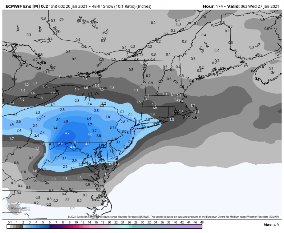
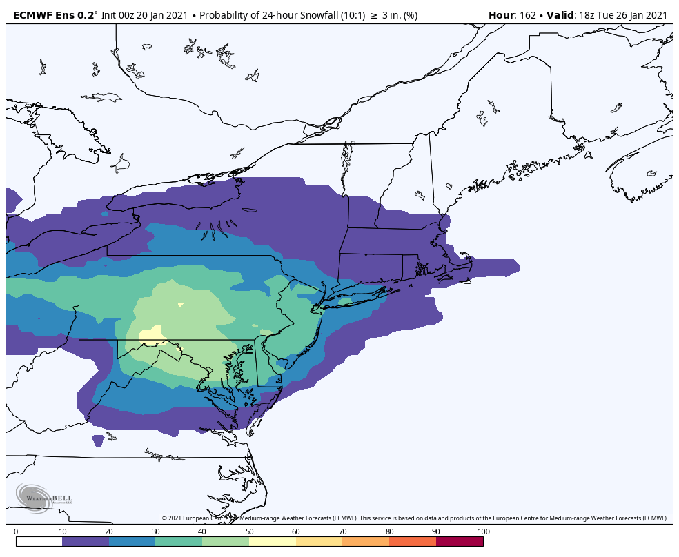
Here is the 0z EPS snow map for just the 3 days near the time period of this early next week winter storm chance.
This is a nice snow signal for over one week out. I like that on this map, CTP is right in the middle with some room to spare on all sides for inevitable adjustments.
-
1
-
-
The 0z EPS still looked really good for the winter storm chance for early next week. The general low track cluster goes to the Ohio Valley and then transfers to the mid Atlantic coast.
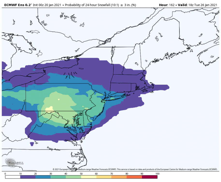
Here are snapshots of one of the 6 hr precip panels early in the storm and then another map with the low clusters later in the storm on Monday night.


Central PA - Winter 2020/2021
in Upstate New York/Pennsylvania
Posted
Here is the 12z EPS snow map for the early week threat.