

WxMan1
-
Posts
786 -
Joined
-
Last visited
Content Type
Profiles
Blogs
Forums
American Weather
Media Demo
Store
Gallery
Everything posted by WxMan1
-

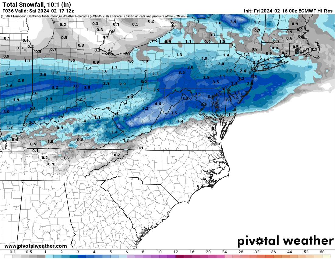
1/19 - The Roulette Wheel 29 Black Storm - OBS
WxMan1 replied to DDweatherman's topic in Mid Atlantic
Yeah it could be a real nice hour, maybe 2 for us in AA east of 95. -
1/19 - The Roulette Wheel 29 Black Storm - OBS
WxMan1 replied to DDweatherman's topic in Mid Atlantic
36/33 with rain and some mangled snowflakes mixed in. I know we were given the Canadian runs some crap (including the high res), But it had the right idea with rain or a mix for a while to start here in the immediate DC metro. My bar is 2". If we can get that, terrific. Wouldn't be surprised for 1-1.5" though. -
1/19 - The Roulette Wheel 29 Black Storm - OBS
WxMan1 replied to DDweatherman's topic in Mid Atlantic
2" is my bar here in central AA County. Again, I want a least a decent coating of fresh insulating snow before the deep freeze during the week. A snowpack can mitigate deep frost depths and frozen water lines, and as a homeowner, yes to this please! -
Yeah, my bar for mid AA (Crofton area) is 2-3" as well. Feel like the boom around here is now more than 4", which is fine with me since I'll be shoveling it. The key however is to get at least some snow. Before we get highs in the teens and lows in the single digits (or lower), I would like at least a fresh blanket of insulating snow to mitigate deepening frost depths and the potential problems therein. Don't need any frozen pipes, thank you very much!
-
Quite a N-S gradient in AA County per the GFS (2-9"). More typical (climo like) that what we've seen this winter, but still, everyone in the immediate DC metro region will be on the lookout for pingers.
-
Fatties falling now in Crofton underneath that band.
-
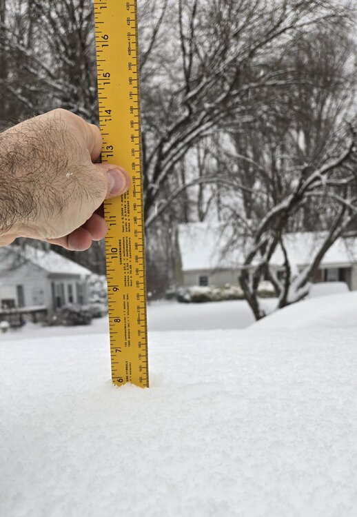
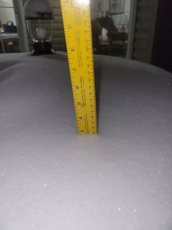
Just a little less than 6" in Crofton MD as of 9 am. Large aggregate flakes now, so I know the pingers are near.
-
I can't believe I'm following two simultaneous threads about 2 significant snow events that would affect our area, all within a week. Pinch me. It would potentially be the most snow in a week over the metros since February 5-11 2010.
-
If that were to happen, it would be the best one week in terms of total snow accumulation for us here in Anne Arundel County since Feb 5-10 2010.
-
Hints of W-E banding in those 10+ inch stripes...within one band in a historically favored area (along I-70). Me thinks the disparity will be a little more in reality. As in, 7-8" vs. 10-11"+ within those bands. Good to see the latest NAM Nest depict what I think could be reality; we all just hope in our back yards we're not in between bands. Then again, that's being greedy, no?
-
Latest from the NWS' experimental Probabilistic Precipitation Portal (https://www.wpc.ncep.noaa.gov/Prob_Precip/). Granted, there will undoubtedly be a sharper gradient with the higher amounts, with lesser amounts on either side of the best FGEN banding, but it does look like most of the forum will get at least 6". That's what I'm hoping for -- and I'm glad to see those 6" probs went up near the M/D line (to 65-70%). 8"+ probs are 45-50% now near the M/D line (also up from previous model cycle), while IMBY here in central AA County up to around 67%. Meanwhile, 12" probs went up IMBY towards Annapolis as well (now 35-40%), no doubt given the robust 12Z high-res CAM guidance. Still thinking 7-9" as a 'mode' for a large chunk of the immediate metro region. Some areas maybe less (farther north), obviously those underneath the best bands have a better chance of hitting 10-11+ inches given the better (deeper) ascent within the dendritic growth layer. More about the membership in this ensemble, which uses the NDFD snow forecast as the 'mode' of the distribution: Welcome to the Probabilistic Precipitation Portal, a resource provided by the National Weather Service to communicate the range and probability of possible precipitation amounts over the next 72 hours (3 days). Data on this page come from the Probabilistic Quantitative Precipitation Forecast (PQPF) and the Probabilistic Winter Precipitation Forecast (PWPF), which are updated twice daily at the Weather Prediction Center. These probabilistic forecasts are derived from a blend of the following: 10 members from the NCEP GEFS ensemble 25 members from the ECMWF ensemble 10 members from the Canadian ensemble 1 member from the NCEP SREF NMMB 2 most recent runs of the NCEP HRRR model 2 most recent runs of the Canadian Regional Model 2 most recent runs of the NCEP NAM 3km CONUS Nest model 4 NCEP Hi-res WRF-ARW model runs NCEP Hi-res FV3LAM model NCEP GFS model ECMWF deterministic model NCEP GEFS ensemble mean NDFD forecast This page updates each hour, typically at 25 minutes past the hour.
.thumb.png.e85db2592b87d6b376feecd64ccdb828.png)
.thumb.png.62a0b901adb59e26767a869b5f445e30.png)
.thumb.png.bf7a2639634b8921b8a06aa9a8b1551c.png)
.thumb.png.25bdb03e3d3cdfd2cfb3a923642538d4.png)
-
32°F in Crofton MD right now, high clouds moving in. Over the years I've come to trust the ASOS/AWOS dewpoints over anything else, so I'm gonna go with the 5°F Td at both BWI and Annapolis.
-
Well, I thank you. There really are some excellent mets on this board, and it has been great following and keeping in touch with them and all the weather enthusiasts for well over a decade now. Heck even during the Eastern US Wx board days. Let me just add... collectively we are essentially a ML/AI model. So much experience in this room, we've seen it all, or just about, in the last couple of decades. That really helps forecasting events like this. Think the mean and mode for the immediate metro region will be 6-8", maybe 7-9". That's what the probabilistic maps are suggesting. Certainly 10-11" will be possible wherever that FGEN band sets up later Monday. Maybe along Rte 50, though probably south. Either way, some cold smoke coming, at the right perfect time of year climatically speaking. Enjoy it everyone!
-
Yeah the ICON is rarely part of any of our blends (especially QPF) at WPC. Verification numbers just don't justify it. Including the NAM12 outside of 48-60 hours, and the NAM Nest outside of 24-36 hours. UKMet is one that cannot be totally discounted (it did nail the Binghamton NY 40"+ snow event a few years back), but I really wish we (at NCEP) could get a hold of their ensemble suite. Obviously, the op ECMWF cannot be discounted (never can), but at least until tonight's runs, I'd still put more credence in the EC ensemble mean. I'm thinking (hoping?) the 12Z ECMWF is the 'low end' for those of us in the metro region north. Still think 6" is a good bar for DC and immediate metro. Interesting that DCA could very well make out better than BWI (how often does that happen?)
-
Scott -- It seems our last 3 events (both last year, and the one in 2022) were these similar W-E cutters with strong frontogenetic support. Areas along and south of the beltway seemed to do very well, especially South Anne Arundel into Calvert County and I believe (for the '22 event) even Fredericksburg. Last year we did quite well in Crofton -Bowie -- 4.1" for the first event, and another 4-5" with the second. All in one week. Our one week of winter, lol.
-
The Weekend Rule? Saturday 2/17 - The Icon Storm
WxMan1 replied to DDweatherman's topic in Mid Atlantic
Lots of dark blues on the 3km NAM on TT, almost from the get-go. All that snow falls within a 4-5 hour period. Definitely some near zero to negative theta lapse rates. -
The Weekend Rule? Saturday 2/17 - The Icon Storm
WxMan1 replied to DDweatherman's topic in Mid Atlantic
00Z Euro, 10-1
-
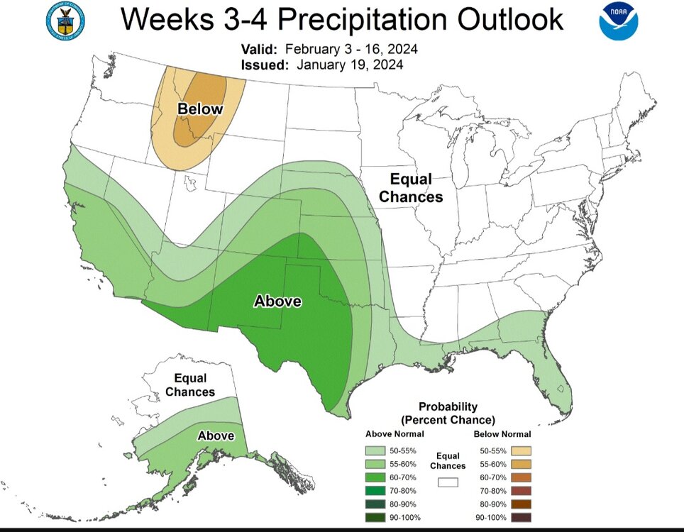
Jan/Early Feb Medium/Long Range Discussion Part 3
WxMan1 replied to WinterWxLuvr's topic in Mid Atlantic
Latest CPC 3-4 week progs..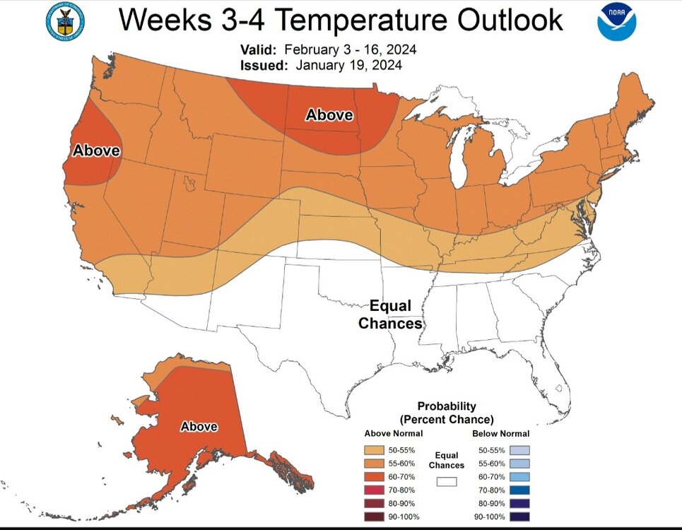

-
Getting more clumping flakes now here in Crofton, def a sign of nearing 0C somewhere along. Oh WAA, you were good today, so it's okay if you want to mix now..
-
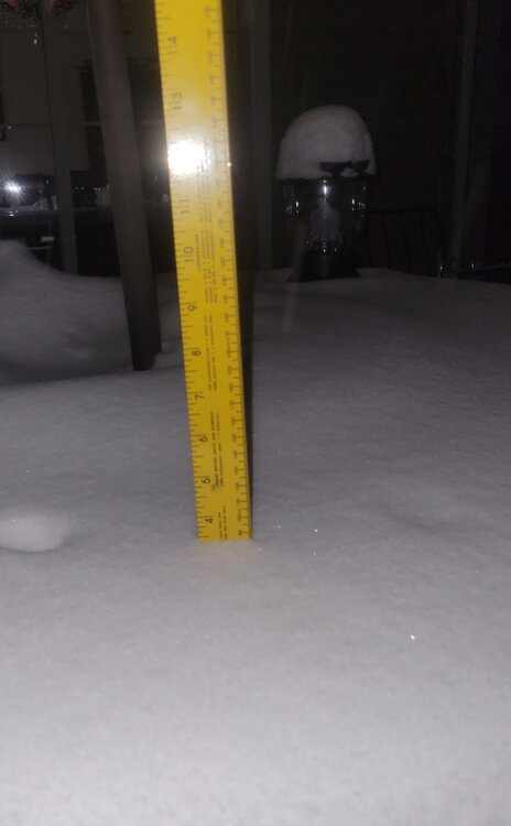
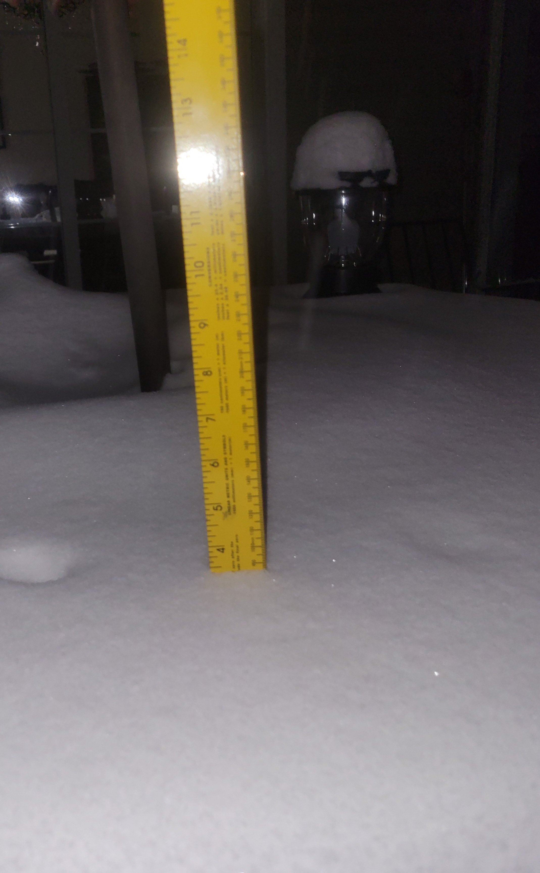
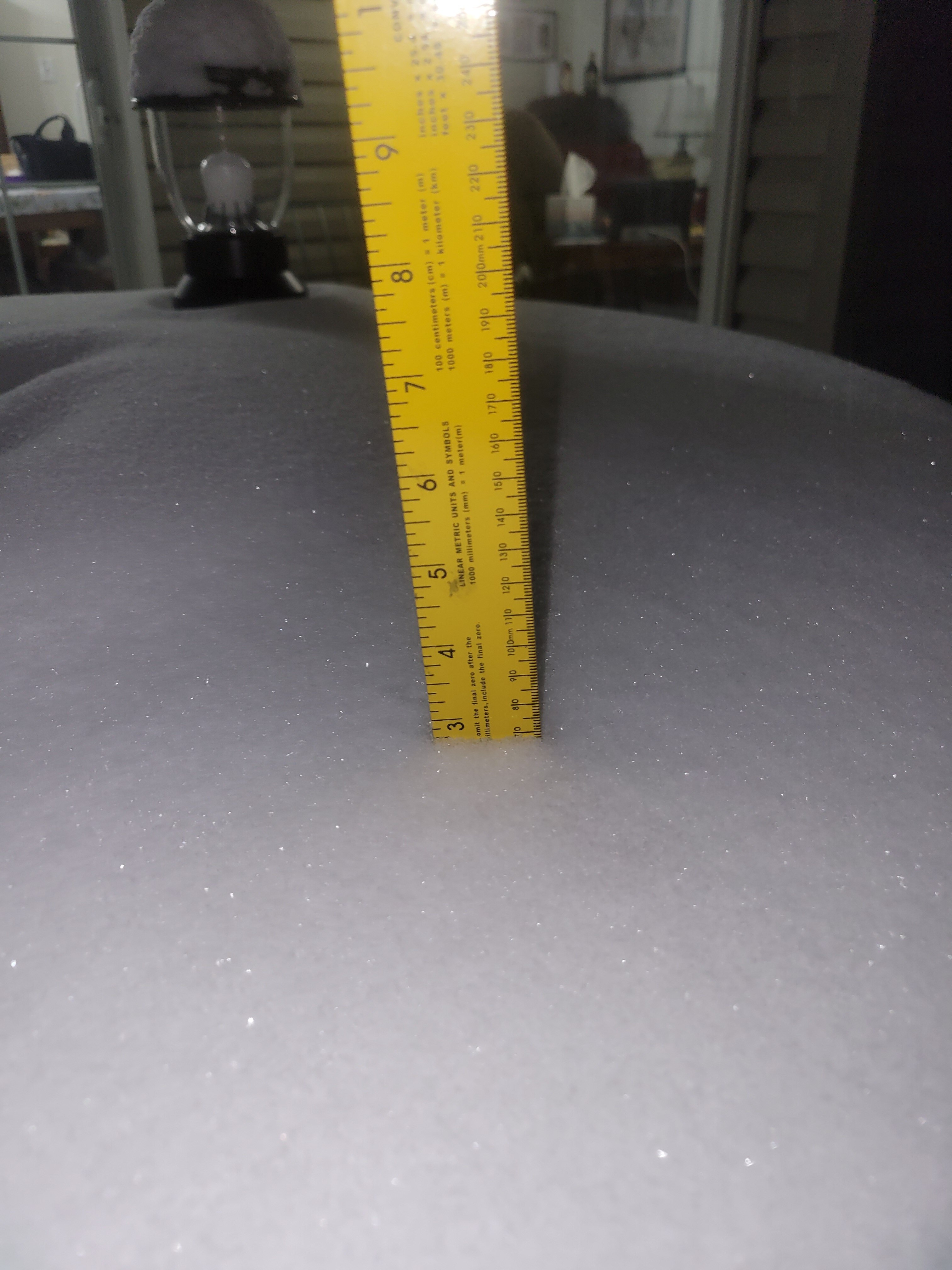
Just got done with shoveling (round 1). Just a little less than 3.5" here in Crofton, still snowing.
-
Very happy to work with these guys at WPC. And to you Scott and Pete: Perfect timing for 3 days off! Yeah baby!
-
A little less than 3" here in Crofton MD as of 9 pm.
-
Jan 15-16 Storm Threat Thread: The Return of Hope??
WxMan1 replied to stormtracker's topic in Mid Atlantic
Yeah...about that... The Rapid Refresh Forecast System -- RRFS -- will ultimately replace the current CAMs, including the NAM, HRRR, ARW, ARW2, and HREF suite. Many aren't on board with that, at least right now, given (a) the poor verification of the RRFS at this point, and (2) while the RRFS is an ensemble, it's ensembles are of the same system. Whereas the HREF is comprised of an ensemble of multiple (different) systems. Not looking forward to that day...hopefully it'll be put off. Rapid Refresh Forecast System GSL, NCEP/EMC, and other partners are working together on a project to design a single-model, convection-allowing, ensemble-based data assimilation, and forecasting system called the Rapid Refresh Forecast System (RRFS). This project aims to develop advanced high-resolution data-assimilation techniques and ensemble-forecasting methods while supporting the unification and simplification of the NCEP modeling suite around the FV3 model. (<-- But the FV3 has been pretty crappy verification-wise). Within the NOAA model unification effort, the RRFS represents the evolution of the NAM, RAP, HRRR, and HREF systems to a new unified deterministic and ensemble storm-scale system. This new system is targeted for initial operational implementation in late 2024 as a planned replacement for the NAMnest, HRRR, HiResWindows, and HREF. While the standalone regional (SAR) FV3 model is being developed for convection-allowing forecasting of a limited area (CONUS), other possible components of the RRFS are being tested now in the experimental, WRF-based High-Resolution Rapid Refresh Ensemble (HRRRE). Experimental runs of the HRRRE at GSL are focused particularly on: Improving 0-12 h high-resolution forecasts through ensemble-based, multi-scale data assimilation Producing spread in 0-36 h ensemble forecasts through initial-condition perturbations, boundary-condition perturbations, and stochastic physics. GSL is the owner and responsible for all data in this AWS S3 Bucket. -
Jan 15-16 Storm Threat Thread: The Return of Hope??
WxMan1 replied to stormtracker's topic in Mid Atlantic
I'd be wary of the NAM folks, even the 3km. Mainly because, well, it's the NAM (btw NCEP can't pull the plug on that model soon enough). I know it's in the shorter range when the NAM could actually be right. But look at some of the CAMS, including the latest (18Z) HREF are all farther south with the axis. I mean, look at the latest HRRR (the one Pivotal Wx map)...heaviest stays south! And were within 24-36 hours of go time. Will be interesting to see the 18Z GFS trends. ECMWF and UKMET, while not as far south with the max QPF and snow axis (into central VA), are definitely more muted with more widespread 2-3" for most, which is consistent with the NBM. Proceed with caution with the NAM3...thumb.png.4141109ff7771a15d66d64fa222da914.png)
.thumb.png.5b8e133ea991ec0415d601fe33db12aa.png)
.thumb.png.5eb36afe23cdd4ba5d717d07151a09c6.png)
.thumb.png.74d5d02c507f815ccab2c089f92c0d24.png)
-
Jan 15-16 Storm Threat Thread: The Return of Hope??
WxMan1 replied to stormtracker's topic in Mid Atlantic
Latest NBM v4.1 and v4.2 snow for Mon-Tue. Lots of 2-3" for the DMV. Not sure why the 4.2 version is a touch higher; might be because of SLR, but I'll take that one..thumb.png.dcf85161eb17f1e370413673d0e85702.png)
.thumb.png.f75a5d9c164673879344bfa7caa5a149.png)


.png.17a8f2ced5ec24ba3a9036165c00bc36.png)
.png.0c87568b73c7df09a8545f50f0f47c61.png)
.png.b6e876d6360bb303cf2737a386b84f78.png)
.png.58b252e1e06a7a6c9627e3a7416b6b65.png)


.png.37e1a2b58eed4cdd935c9576d0f044c4.png)
.png.49d5273f2dce7a1ea7e119718e6e93d7.png)
.png.aebfdc68c8829007f6723760e02fee84.png)
.png.2bbc02d736ec23ddc8bc57f8eb546bb3.png)
.png.dc81a69c2509b43563ef2b62c85303ed.png)
.png.078fbaeb2495e3a3be1fbfd3f2f0e220.png)