mikeysed
-
Posts
278 -
Joined
-
Last visited
Content Type
Profiles
Blogs
Forums
American Weather
Media Demo
Store
Gallery
Everything posted by mikeysed
-
Two Mdt to high impact events NYC subforum; wknd Jan 6-7 Incl OBS, and mid week Jan 9-10 (incl OBS). Total water equiv by 00z/11 general 2", possibly 6" includes snow-ice mainly interior. RVR flood potential increases Jan 10 and beyond. Damaging wind.
mikeysed replied to wdrag's topic in New York City Metro
After GEFS is the Ukie up? -
Two Mdt to high impact events NYC subforum; wknd Jan 6-7 Incl OBS, and mid week Jan 9-10 (incl OBS). Total water equiv by 00z/11 general 2", possibly 6" includes snow-ice mainly interior. RVR flood potential increases Jan 10 and beyond. Damaging wind.
mikeysed replied to wdrag's topic in New York City Metro
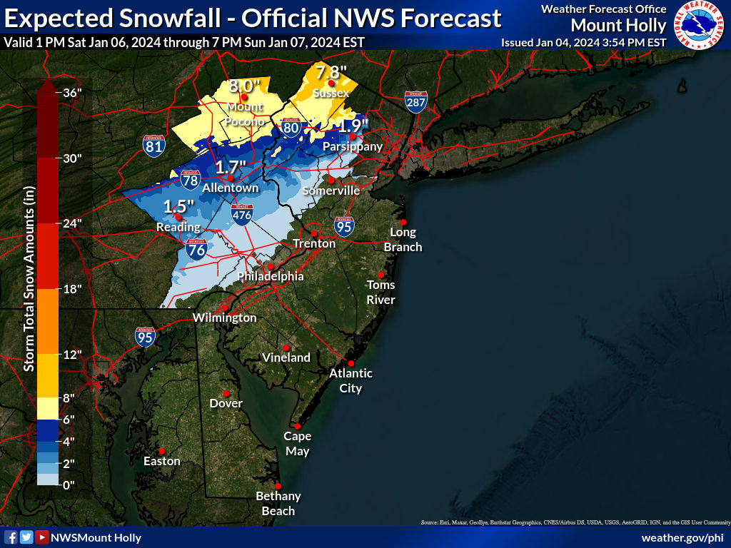
1-2 inches in Parsippany is comical. 4 to 6 minimum. If trends continue tonight, 6 to 8 would be more realistic.- 3,610 replies
-
- 1
-

-
- snow
- heavy rain
- (and 5 more)
-
Two Mdt to high impact events NYC subforum; wknd Jan 6-7 Incl OBS, and mid week Jan 9-10 (incl OBS). Total water equiv by 00z/11 general 2", possibly 6" includes snow-ice mainly interior. RVR flood potential increases Jan 10 and beyond. Damaging wind.
mikeysed replied to wdrag's topic in New York City Metro
IMO Mt Holly is way low for morris County. Out of all the NWS areas based on models etc. They seem crazy for 1 to 5 for most of the county.- 3,610 replies
-
- 1
-
-
- snow
- heavy rain
- (and 5 more)
-
Two Mdt to high impact events NYC subforum; wknd Jan 6-7 Incl OBS, and mid week Jan 9-10 (incl OBS). Total water equiv by 00z/11 general 2", possibly 6" includes snow-ice mainly interior. RVR flood potential increases Jan 10 and beyond. Damaging wind.
mikeysed replied to wdrag's topic in New York City Metro
They lowered most areas yet the models increased moderately.- 3,610 replies
-
- 3
-

-
-
- snow
- heavy rain
- (and 5 more)
-
Two Mdt to high impact events NYC subforum; wknd Jan 6-7 Incl OBS, and mid week Jan 9-10 (incl OBS). Total water equiv by 00z/11 general 2", possibly 6" includes snow-ice mainly interior. RVR flood potential increases Jan 10 and beyond. Damaging wind.
mikeysed replied to wdrag's topic in New York City Metro
Wow Mt Holly is out to lunch. This is their new map?!
- 3,610 replies
-
- 4
-

-
-

-
- snow
- heavy rain
- (and 5 more)
-
Two Mdt to high impact events NYC subforum; wknd Jan 6-7 Incl OBS, and mid week Jan 9-10 (incl OBS). Total water equiv by 00z/11 general 2", possibly 6" includes snow-ice mainly interior. RVR flood potential increases Jan 10 and beyond. Damaging wind.
mikeysed replied to wdrag's topic in New York City Metro
If this trend continues by tonight NYC could be 6+ and have warning criteria. Would only need a 20 mile swing for that to happen- 3,610 replies
-
- 4
-
-
-
-
- snow
- heavy rain
- (and 5 more)
-
Two Mdt to high impact events NYC subforum; wknd Jan 6-7 Incl OBS, and mid week Jan 9-10 (incl OBS). Total water equiv by 00z/11 general 2", possibly 6" includes snow-ice mainly interior. RVR flood potential increases Jan 10 and beyond. Damaging wind.
mikeysed replied to wdrag's topic in New York City Metro
Euro caving to the GFS from yesterday- 3,610 replies
-
- 2
-
-
- snow
- heavy rain
- (and 5 more)
-
Two Mdt to high impact events NYC subforum; wknd Jan 6-7 Incl OBS, and mid week Jan 9-10 (incl OBS). Total water equiv by 00z/11 general 2", possibly 6" includes snow-ice mainly interior. RVR flood potential increases Jan 10 and beyond. Damaging wind.
mikeysed replied to wdrag's topic in New York City Metro
Snow map of GEFS avail to post? -
Two Mdt to high impact events NYC subforum; wknd Jan 6-7 Incl OBS, and mid week Jan 9-10 (incl OBS). Total water equiv by 00z/11 general 2", possibly 6" includes snow-ice mainly interior. RVR flood potential increases Jan 10 and beyond. Damaging wind.
mikeysed replied to wdrag's topic in New York City Metro
Do you have kuchera on pivotal ? Weatherall kuchera is much lower -
Two Mdt to high impact events NYC subforum; wknd Jan 6-7 Incl OBS, and mid week Jan 9-10 (incl OBS). Total water equiv by 00z/11 general 2", possibly 6" includes snow-ice mainly interior. RVR flood potential increases Jan 10 and beyond. Damaging wind.
mikeysed replied to wdrag's topic in New York City Metro
RGEM is warm. Least amount for those on the borderline spots immediate tri-state -
Two Mdt to high impact events NYC subforum; wknd Jan 6-7 Incl OBS, and mid week Jan 9-10 (incl OBS). Total water equiv by 00z/11 general 2", possibly 6" includes snow-ice mainly interior. RVR flood potential increases Jan 10 and beyond. Damaging wind.
mikeysed replied to wdrag's topic in New York City Metro
With 8" lollis in the mountainous areas (Highland lakes, West Milford, Randolph, Mahwah, etc) -
Two Mdt to high impact events NYC subforum; wknd Jan 6-7 Incl OBS, and mid week Jan 9-10 (incl OBS). Total water equiv by 00z/11 general 2", possibly 6" includes snow-ice mainly interior. RVR flood potential increases Jan 10 and beyond. Damaging wind.
mikeysed replied to wdrag's topic in New York City Metro
Is the Ukie after the Euro? -
Two Mdt to high impact events NYC subforum; wknd Jan 6-7 Incl OBS, and mid week Jan 9-10 (incl OBS). Total water equiv by 00z/11 general 2", possibly 6" includes snow-ice mainly interior. RVR flood potential increases Jan 10 and beyond. Damaging wind.
mikeysed replied to wdrag's topic in New York City Metro
Looking like up the mountain 4-6" and down Rt 22/ South of 78 2-4" at the moment for us from today's trends.- 3,610 replies
-
- 2
-
-
- snow
- heavy rain
- (and 5 more)
-
Two Mdt to high impact events NYC subforum; wknd Jan 6-7 Incl OBS, and mid week Jan 9-10 (incl OBS). Total water equiv by 00z/11 general 2", possibly 6" includes snow-ice mainly interior. RVR flood potential increases Jan 10 and beyond. Damaging wind.
mikeysed replied to wdrag's topic in New York City Metro
CMC is looking like the GFS -
Two Mdt to high impact events NYC subforum; wknd Jan 6-7 Incl OBS, and mid week Jan 9-10 (incl OBS). Total water equiv by 00z/11 general 2", possibly 6" includes snow-ice mainly interior. RVR flood potential increases Jan 10 and beyond. Damaging wind.
mikeysed replied to wdrag's topic in New York City Metro
April 2018 was Yankees opening day. I am in southern morris county we got 8 inches. I couldn't believe how quickly it was sticking in daylight and how heavy the rates were. Game got postponed about 2 hours only before gates opened, I was already on my way into the City. Was ridiculous they waited as long as they did.- 3,610 replies
-
- 1
-
-
- snow
- heavy rain
- (and 5 more)
-
Two Mdt to high impact events NYC subforum; wknd Jan 6-7 Incl OBS, and mid week Jan 9-10 (incl OBS). Total water equiv by 00z/11 general 2", possibly 6" includes snow-ice mainly interior. RVR flood potential increases Jan 10 and beyond. Damaging wind.
mikeysed replied to wdrag's topic in New York City Metro
Kuchera and 10:1 arent too far off. It's colder.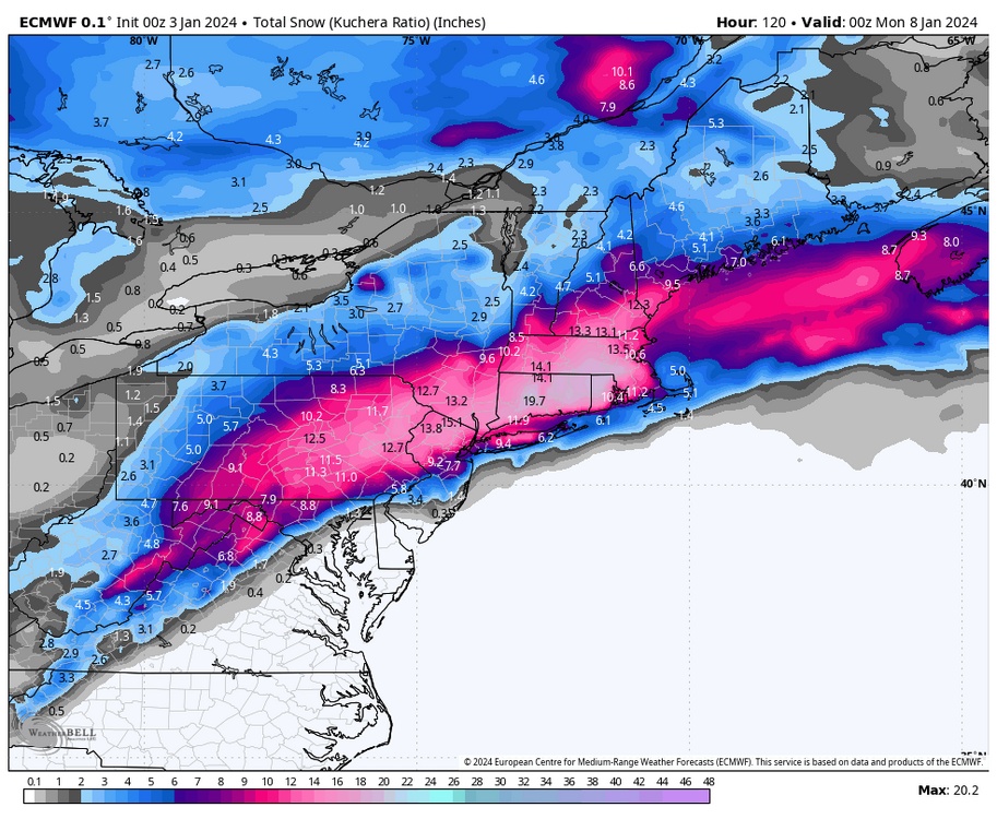
- 3,610 replies
-
- 1
-
-
- snow
- heavy rain
- (and 5 more)
-
Two Mdt to high impact events NYC subforum; wknd Jan 6-7 Incl OBS, and mid week Jan 9-10 (incl OBS). Total water equiv by 00z/11 general 2", possibly 6" includes snow-ice mainly interior. RVR flood potential increases Jan 10 and beyond. Damaging wind.
mikeysed replied to wdrag's topic in New York City Metro
Do you have the Kuchera map? As I don't think 10:1 will be accurate for i95 and east -
Hi there, yes Salem MA. Get out really? GF will love that. I will need beer or cocktails. I will be among the masses (sigh)
-
Heading to Salem this weekend from NJ. Looks like rain... how bad will it be Friday and Saturday? NJ actually looks like the rain may be worse Friday and then clearing for Saturday.
-
Insane snow. Haven't seen these rates in some time. Easily 1.5-2" rates in Southern Morris County. Just came from East to West about 15 minutes and roads are all covered. Have almost 2 inches... if this thing even turns over to mix at 5 am we will have 8" easy. Probably more.
-
End of January - the storm that LI and Boston got 24"+ Ridge and Warren registered 7" on the text product from Mt Holly. Skywarn spotter and Public.
-
Basking Ridge reported 7" during the one storm, doubt you were that much lower if at all.
-
Keep in mind we all have a solid snow pack right now, Whatever falls is going to fall on that as temps plummet.
-
My grandfather, Meteorologist Franco Buonvilla, always told me... "Michael, Mother Nature will do what it wants and tell my models vaffanculo. If you get lucky you will not have school and your grandmother is probably making you penne rigate"
-
I am really in a bind. I am leaving from North NJ to Lake Placid on Saturday AM to Monday... temps alone are a story up there with highs -5, lows around -20. But I think it starts up there after midnight Sunday, and Monday will be far too dangerous to drive from LP to North NJ to head home. I probably should stay another day or leave Sunday night but that's a far drive for 1.5 days...