LakeEffectKing
-
Posts
4,476 -
Joined
-
Last visited
Content Type
Profiles
Blogs
Forums
American Weather
Media Demo
Store
Gallery
Everything posted by LakeEffectKing
-
 For 10 days? Looks low to me, especially especially of L. Ontario.
 -
For awhile, tomorrow through the time of the Arctic fropa, we should see occasional rates of 5-7" per hour, and from my experience, as that front passes and is oriented with the band and merges, there could be a very brief period of mind blowing rates...seen it twice in my life when living in Parish. I took about an 80/20 ratio (Rgem/3k Nam) when making my call. I believe the difference between the 2 models is that the nam keeps the band as a lakeshore band, where as the regional Canadian brings the band closer to the major axis of the lake.
-
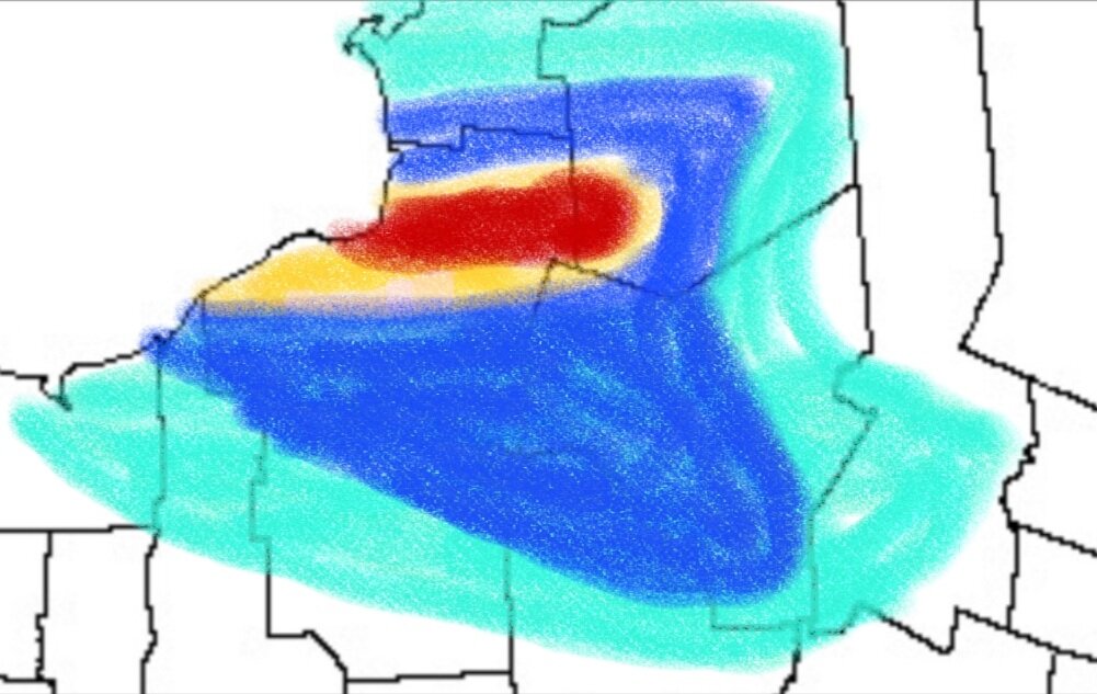
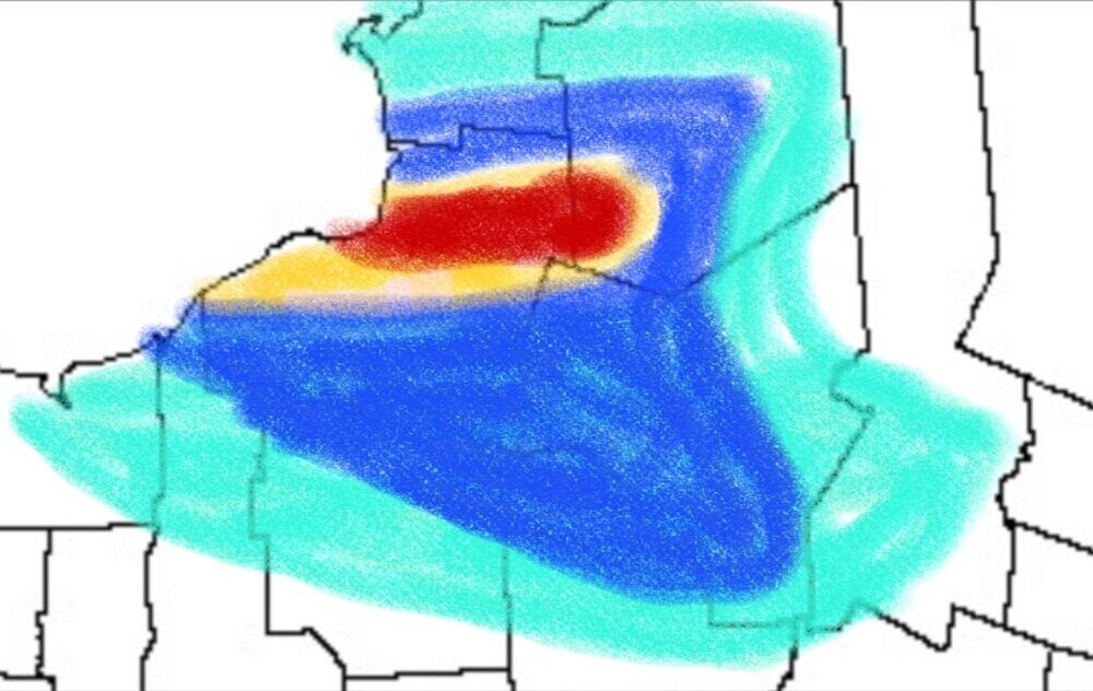
Thoughts as of now for L. Ontario band through Tue. morning. Teal: 3-6" Blue: 6-10" Yellow: 10-20" Red: 20-40"
-
Nothing, as of yet, has been created to accurately depict 20-40:1 ratios...
-
Never mind....you were talking about the 3k...
-
South of you??? I thought you were in Pulaski /Altmar area...?
-
Yeah...you (and I) will get two doses as it appears in modeling... First, between 9pm and Midnight tomorrow night...Then again Monday eve. as the band sweeps through...then 12 hours of mood, pixie dust...
-
And for potential bombs off the EC, if this verifies.
-
Yes...that is true...if it forms there...but this will start out south and move north, and if anything, imo, will jackpot a bit further south than what is being depicted by the Rgem...albeit by only 5- 8 miles.
-
Well I'm guessing that anywhere south of Central Square and points south, get 2 to 4" as that band swings South. With probably a little bit more behind that, as the deep Arctic air settles in....and we get into a similar situation as we did late last night into this morning. Wolfie should be good for a couple feet.
-
Yes it most definitely will sweep off the lake.... However in these East West oriented bands, expected to get hung up in the Tug a little bit... Orienting itself from northeast to Southwest as it pushes off the lake. Models tend to move the band too quickly southward in these situations over land.
-
In my opinion you are about in the most perfect spot.... Aside from higher elevations to your East.
-
And remember, even Kuchera way underestimated this past event.....I think by late Sun night through Monday, the ratios will be similar...25-35:1...do the math....
-
Ratios will be sky high late Sun. Night into Monday. IF this locks in, 2' amounts should be easily obtainable from between Mexico/Pulaski to Adams and inland from there. I received 2" more last night for an event total of just over 8"....not too shabby!
-
.... And no thaw afterward, with snow piling on the ice covered branches/wires.
-
Measurement before bed...6.5" in Caz....light snow. Looking forward to Sun. Night/Monday for some impressive rates in C. Oswego Co.....they see 12 -16" easily, IMO.
-
Also, with regard to the radar....as the inversion lowers/crashes during the finalstages of an LES event, you are in effect snowing from a couple of thousand feet AGL...and radar is just over shooting most of where the snow is originating from.
-
Just got home in Caz...5.5".....started moderate snow here about 1/2 hour ago after couple hour break.
-
Euro too....
-
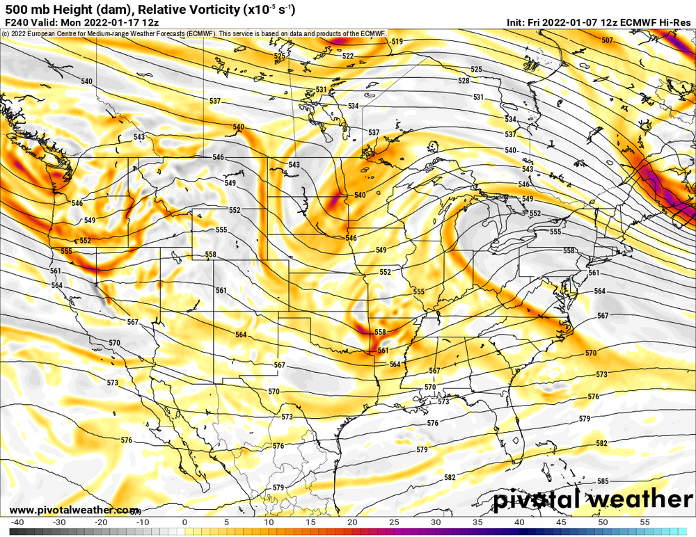
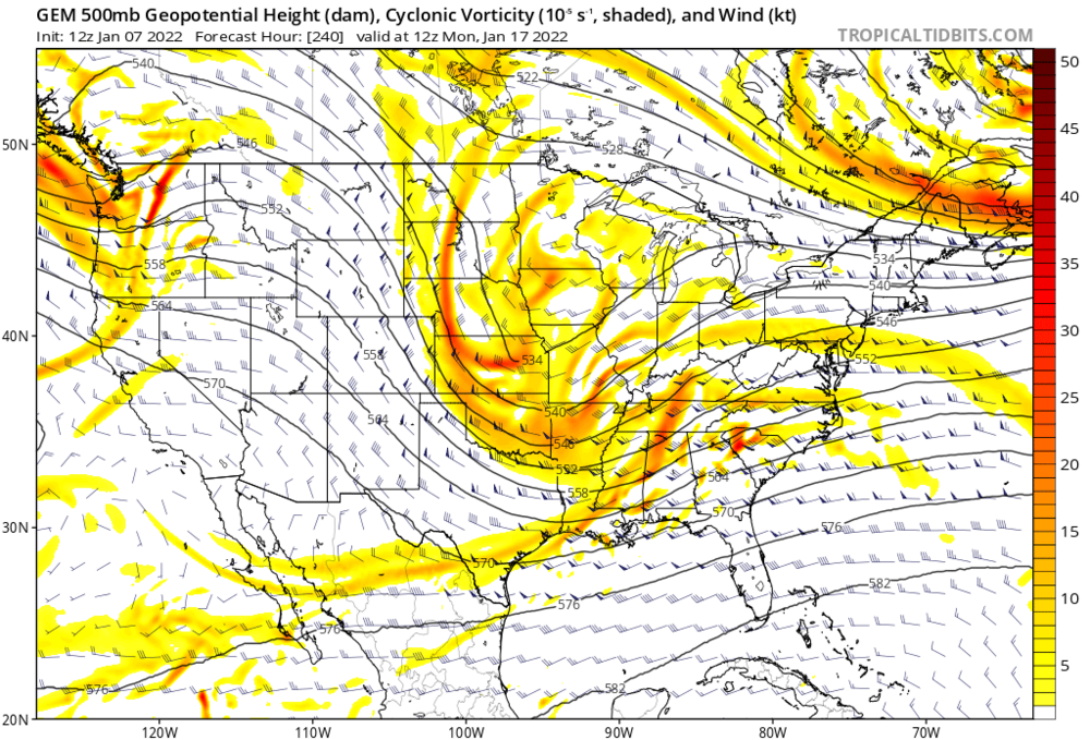
If this T+240 panel verified on the 12z GGEM, extrapolated, it would be a huge hit, I'd imagine..
-
Currently at Caz.... About 4.5" new...
-
For just a little bit, ahead of a small short wave crossing the lake. It'll turn more northwesterly and then drier air moves in this evening as inversion lowers to dry up left overs...
-
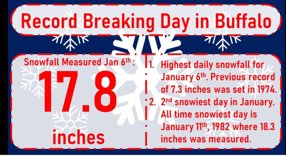
From BUF NWS FB page: ....looks like a coupon I should clip...
-
Congrats to all who cashed in! Nice event for the metro!!
-
Suprise .8" from coastal this morning.... Looks like us folks SE of Ontario will be thrown some LES scraps today. Max totals of 8-10" probably far W. Oswego Co., N. Cayuga Co., NW Onondaga Co. by midnight. Should be in two waves....from 8-10 am (band falls off lakeshore) and then from 1pm- 8pm (band re-forms early afternoon) and slowly tapering overnight... should be a single band...with a couple smaller/lighter bands in Oswego and Wayne Cos. NWS @ SYR about 4-5"...and around 6-7" IMBY, Caz.