LakeEffectKing
-
Posts
4,476 -
Joined
-
Last visited
Content Type
Profiles
Blogs
Forums
American Weather
Media Demo
Store
Gallery
Everything posted by LakeEffectKing
-

Feb 2-4th Snowstorm- Observation Thread
LakeEffectKing replied to BuffaloWeather's topic in Upstate New York/Pennsylvania
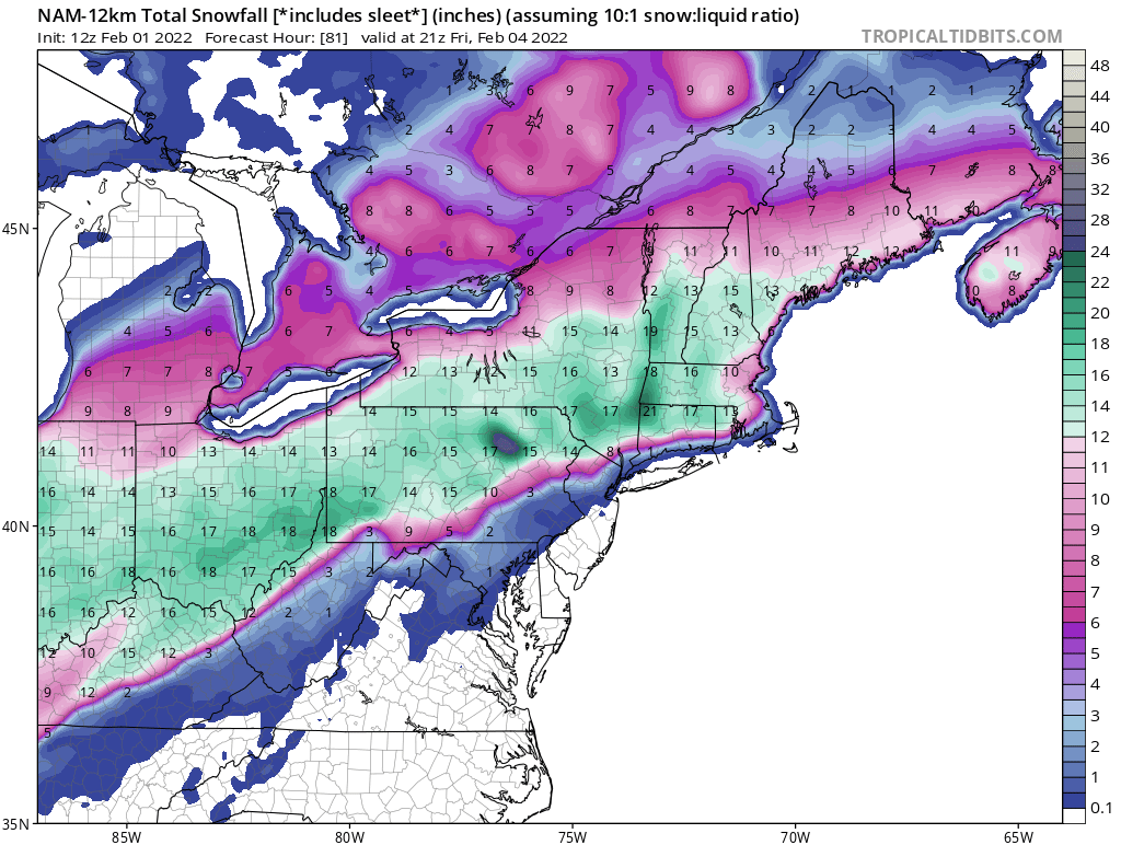
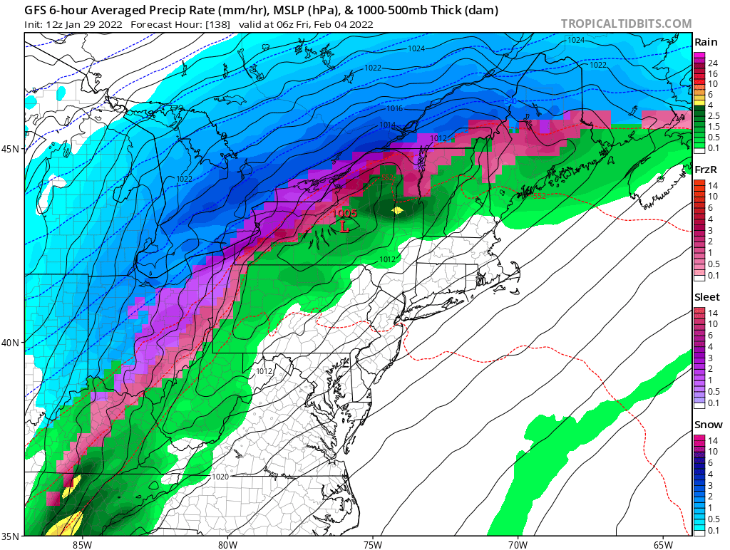
The 12Z NAM is really lingering the snow through Friday afternoon for central and most of W. New York. -
Feb 2-4th Snowstorm- Observation Thread
LakeEffectKing replied to BuffaloWeather's topic in Upstate New York/Pennsylvania
BTW, moderate snow here in Cazenovia. Flake size is ok. -
Feb 2-4th Snowstorm- Observation Thread
LakeEffectKing replied to BuffaloWeather's topic in Upstate New York/Pennsylvania
Relative to lead times, all the models did fairly well.. They all wavered a bit but at times showed the general idea. Over the last day and a 1/2 the euro seemed pretty steady. But then again, verification hasn't happened yet, lol! -
Feb 2-4th Snowstorm- Observation Thread
LakeEffectKing replied to BuffaloWeather's topic in Upstate New York/Pennsylvania
Just flipped in Caz. -
Feb 2-4th Snowstorm- Observation Thread
LakeEffectKing replied to BuffaloWeather's topic in Upstate New York/Pennsylvania
Really like both forecasts. Maybe move the transition zone se by 20 miles...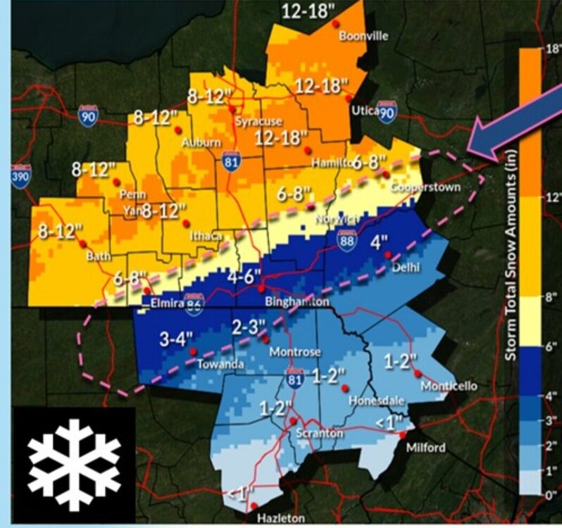
-
Feb 2-4th Snowstorm- Observation Thread
LakeEffectKing replied to BuffaloWeather's topic in Upstate New York/Pennsylvania
Cold conveyor belt. -
Feb 2-4th Snowstorm- Observation Thread
LakeEffectKing replied to BuffaloWeather's topic in Upstate New York/Pennsylvania
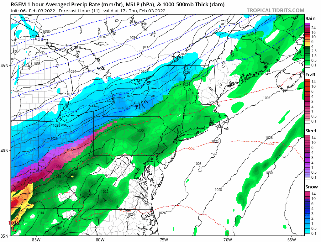
You can really see the moistening CCB from the northeast on a rapid loop of the Rgem prog. Look at the bands of snow coming in from the northeast along the St. Lawrence River Valley and New England, as the system as a whole moves ENE'ward.
-
Feb 2-4th Snowstorm- Observation Thread
LakeEffectKing replied to BuffaloWeather's topic in Upstate New York/Pennsylvania
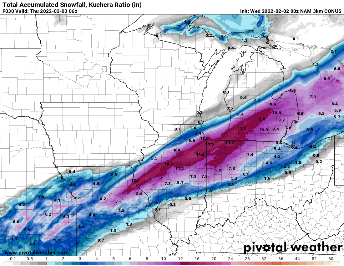
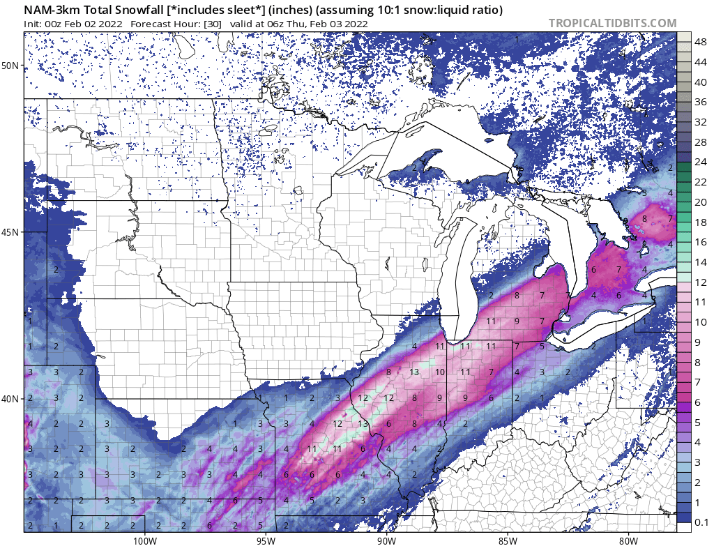
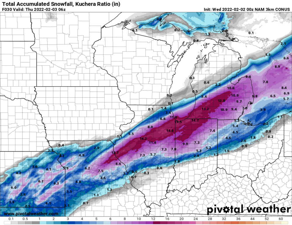
The 3K Nam from 00z 02/02 did really well with the first wave out west. Notice that verification came generally somewhere between straight 10:1 ratios, and the Kuchera method/algorithm.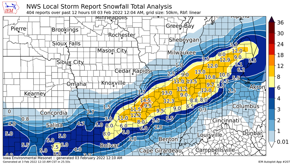

-
Feb 2-4th Snowstorm- Observation Thread
LakeEffectKing replied to BuffaloWeather's topic in Upstate New York/Pennsylvania
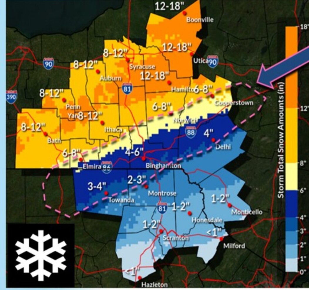
And I like your call for up your way...6-10 is probably a real good bet. -
Feb 2-4th Snowstorm- Observation Thread
LakeEffectKing replied to BuffaloWeather's topic in Upstate New York/Pennsylvania
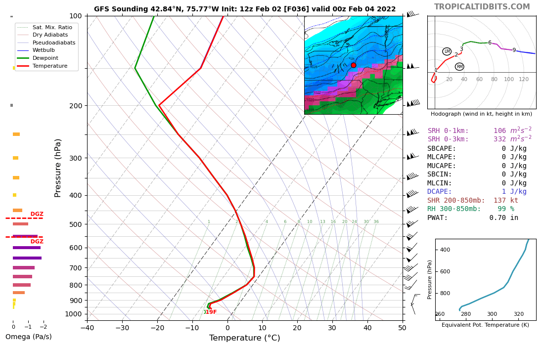
Yeah Brian...first part of the storm for CNY through 2pm will be a nothing burger... I've been watching the trends over the last couple days with regard to Omega and DGZ, and it has trended better for this evening. Liking my spot in Caz...13" is my call for here. -
Feb 2-4th Snowstorm- Observation Thread
LakeEffectKing replied to BuffaloWeather's topic in Upstate New York/Pennsylvania
Me Too! But I seem to always wake up automatically around 1AM during an impending storm. -
Feb 2-4th Snowstorm- Observation Thread
LakeEffectKing replied to BuffaloWeather's topic in Upstate New York/Pennsylvania
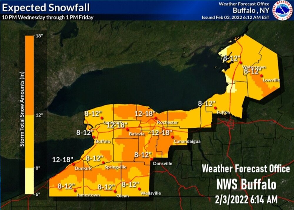
Embrace this event... It may very well be the only event in a long long time that our whole upstate, cny, wny, eny, (and hopefully our bgm and southeastern members) get a uniform 8-14" event... -
Feb 2-4th Snowstorm- Observation Thread
LakeEffectKing replied to BuffaloWeather's topic in Upstate New York/Pennsylvania
F that!!! I'm staying up for more model erotica!!!! -
Feb 2-4th Snowstorm- Observation Thread
LakeEffectKing replied to BuffaloWeather's topic in Upstate New York/Pennsylvania
Because it's the 1st warm day where it wouldn't turn your car into an ice shell... And any time you can get extra salt off your car... the better. -
Feb 2-4th Snowstorm- Observation Thread
LakeEffectKing replied to BuffaloWeather's topic in Upstate New York/Pennsylvania
Let's check to see if the snowfall amounts are overperforming with SLR's in Indiana and Ohio later....should give us an idea of ratios.. -
Model Mayhem Snowstorm! 2/2-2/4
LakeEffectKing replied to BuffaloWeather's topic in Upstate New York/Pennsylvania
I think ratios are going to be a little bit better than 10 to 1... The omega in the DGZ look a little bit better....not great, but better than previous cycles.
-
Model Mayhem Snowstorm! 2/2-2/4
LakeEffectKing replied to BuffaloWeather's topic in Upstate New York/Pennsylvania
Nam shows that "last wave" that BGM discussed. Something to watch if it trends stronger, could bump totals up especially CNY and southeastward... -
Model Mayhem Snowstorm! 2/2-2/4
LakeEffectKing replied to BuffaloWeather's topic in Upstate New York/Pennsylvania
Yeah, the 12z Euro is really the first to get the entire sub forum group, including the east and southeast folks.... -
Model Mayhem Snowstorm! 2/2-2/4
LakeEffectKing replied to BuffaloWeather's topic in Upstate New York/Pennsylvania
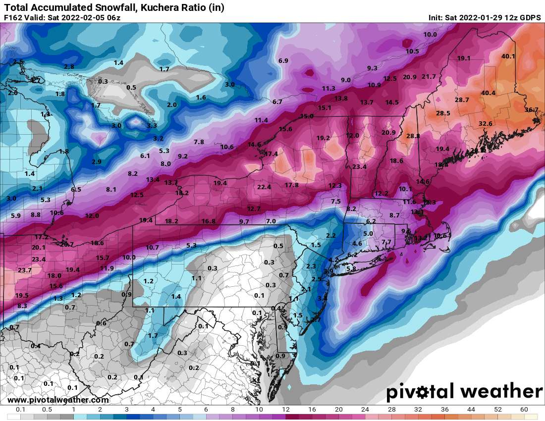
Nice bump in totals generally..
-
Model Mayhem Snowstorm! 2/2-2/4
LakeEffectKing replied to BuffaloWeather's topic in Upstate New York/Pennsylvania
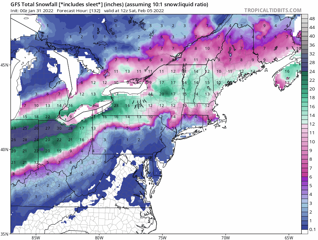
A few thoughts... This will be historic....for places like St. Louis, mid south (AR, KY, etc.) for snow and significant ice. For here, this will be a long duration event, where the band of snowfall sets up.. Snowfall rates will be light to moderate throughout the duration.....dendrite size, ATT, look average to below average (as several posters have mentioned, omega within the DGZ, is not great, as modeled now). This should not be an extremely high impact event, relative to travel....8-14" over 24-36 hrs. is almost pedestrian around here...or it used to be, lol! And of course, there will be a sharp cut off (snowfall wise) somewhere between CNY and the Catskills. Again, for where the snow zone sets up, it will be a wonderful winter scene for a solid day or so! Last thought....watch out for next Sunday-Monday.... -
Model Mayhem Snowstorm! 2/2-2/4
LakeEffectKing replied to BuffaloWeather's topic in Upstate New York/Pennsylvania
Uh oh...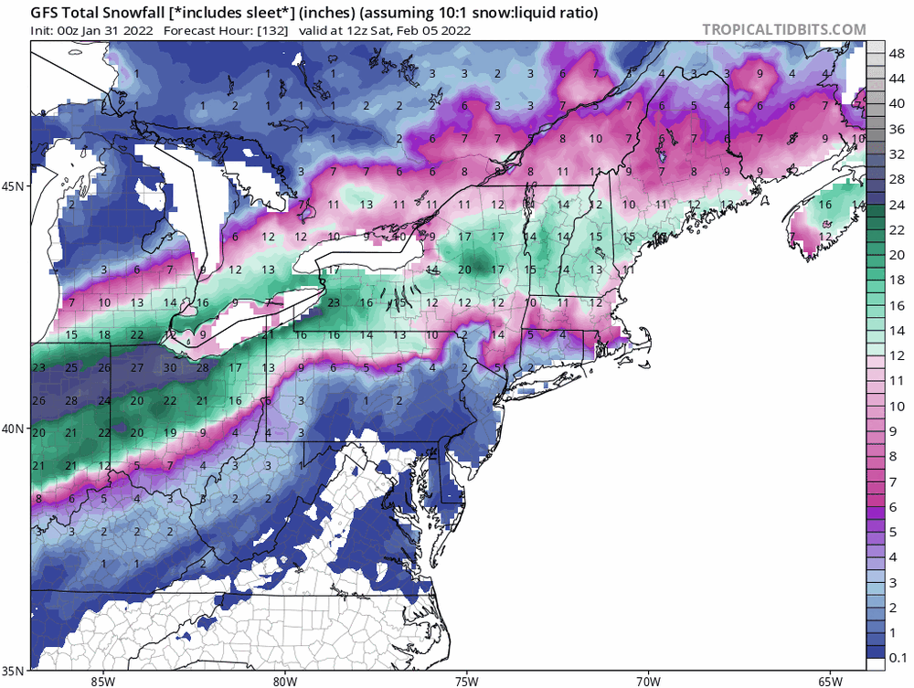
-
This far out...prbably a bit hard to assess the potential, without seeing how deep the cold air is as the front slides through....but there certainly is an elevated risk, based on some model depictions.
-
Someone in our subforum is going to get the goods.....and a chance that all can score big..let's stay together family...
-
Through the entire event...

-
@TugHillMattDid you say you were moving??? When??? I'll help you pack....