LakeEffectKing
-
Posts
4,476 -
Joined
-
Last visited
Content Type
Profiles
Blogs
Forums
American Weather
Media Demo
Store
Gallery
Everything posted by LakeEffectKing
-

Back to Back Major Synoptic Snowstorms!
LakeEffectKing replied to BuffaloWeather's topic in Upstate New York/Pennsylvania
Yeah, Amarillo just upgraded to a WSW. -
Back to Back Major Synoptic Snowstorms!
LakeEffectKing replied to BuffaloWeather's topic in Upstate New York/Pennsylvania
I think, with decent ratios, someone in S. Oswego Co. or N. Onondaga Co. will see 8"+ overnight. -
Back to Back Major Synoptic Snowstorms!
LakeEffectKing replied to BuffaloWeather's topic in Upstate New York/Pennsylvania
Not strong, yet...but certainly some seeding, and maybe a bit of the remnant vertical circulation. If it does make a strong connection it will become oriented a little bit more WNW as opposed to due West along the South shore. Either way, I think you and Brian are in pretty good shape...but it will be pretty narrow.
-
Back to Back Major Synoptic Snowstorms!
LakeEffectKing replied to BuffaloWeather's topic in Upstate New York/Pennsylvania
Mod snow in Bridgeport. -
Back to Back Major Synoptic Snowstorms!
LakeEffectKing replied to BuffaloWeather's topic in Upstate New York/Pennsylvania
Hey @wolfie09you getting pounded? -
Back to Back Major Synoptic Snowstorms!
LakeEffectKing replied to BuffaloWeather's topic in Upstate New York/Pennsylvania
h500 does not look great imo to get this further NW, att. -
Back to Back Major Synoptic Snowstorms!
LakeEffectKing replied to BuffaloWeather's topic in Upstate New York/Pennsylvania
-
Back to Back Major Synoptic Snowstorms!
LakeEffectKing replied to BuffaloWeather's topic in Upstate New York/Pennsylvania
This hobby humbles us all.... -
Back to Back Major Synoptic Snowstorms!
LakeEffectKing replied to BuffaloWeather's topic in Upstate New York/Pennsylvania
Well, the issue (post mortem) was 2 fold. I think it is just difficult for the models to handle slp placement when upper levels support an slp on top of the mountains...then/if models do resolve the correct lp placement (in this case to the west) they seem to way underdo the warm air advection. All IMO, of course. -
Back to Back Major Synoptic Snowstorms!
LakeEffectKing replied to BuffaloWeather's topic in Upstate New York/Pennsylvania
For as long as I can remember, models underestimate the warmth thrown northward (at many levels) when systems are west of the apps....and it happens alot, but this was extreme! -
Back to Back Major Synoptic Snowstorms!
LakeEffectKing replied to BuffaloWeather's topic in Upstate New York/Pennsylvania
You are not alone my friend. This was a case where we witnessed models weaknesses.... -
Back to Back Major Synoptic Snowstorms!
LakeEffectKing replied to BuffaloWeather's topic in Upstate New York/Pennsylvania
Wow....insane!! -
Back to Back Major Synoptic Snowstorms!
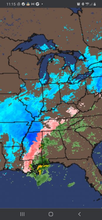
LakeEffectKing replied to BuffaloWeather's topic in Upstate New York/Pennsylvania
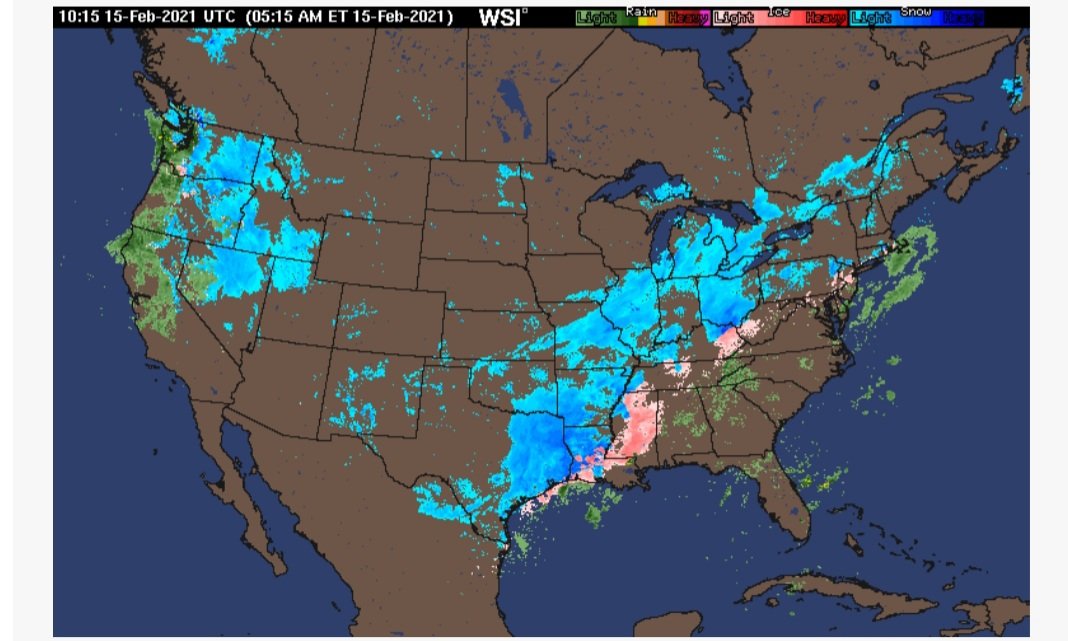
Looks like the WSI radar needs some tweeking..
-
Back to Back Major Synoptic Snowstorms!
LakeEffectKing replied to BuffaloWeather's topic in Upstate New York/Pennsylvania
IP+ in Caz. -
Back to Back Major Synoptic Snowstorms!
LakeEffectKing replied to BuffaloWeather's topic in Upstate New York/Pennsylvania
Started in Caz..pretty steady considering the returns over me....1.5" during day today. Temp at 22 currently. -
Back to Back Major Synoptic Snowstorms!
LakeEffectKing replied to BuffaloWeather's topic in Upstate New York/Pennsylvania
If the WSI precipitation type radar Is to be believed, then the majority of the models have been too far Northwest with the snow sleet line all day long. I think the pingers stay south..models, imo, are having a tough time with the cold air at the low-levels with the track of this system..... -
Back to Back Major Synoptic Snowstorms!
LakeEffectKing replied to BuffaloWeather's topic in Upstate New York/Pennsylvania
Me more than anyone!!! -
Back to Back Major Synoptic Snowstorms!
LakeEffectKing replied to BuffaloWeather's topic in Upstate New York/Pennsylvania
Just something to keep track of as we go into the evening. It may have something to do with the atmospheric set up down there that is throwing the models off with the algorithms... Not sure.. -
Back to Back Major Synoptic Snowstorms!
LakeEffectKing replied to BuffaloWeather's topic in Upstate New York/Pennsylvania
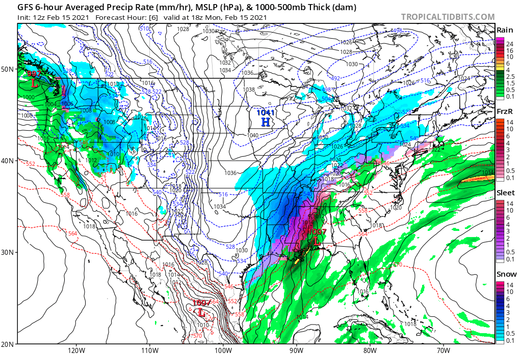
Again, GFS initializes sn/ip line wrong. 12z GFS at 18z: Current radar: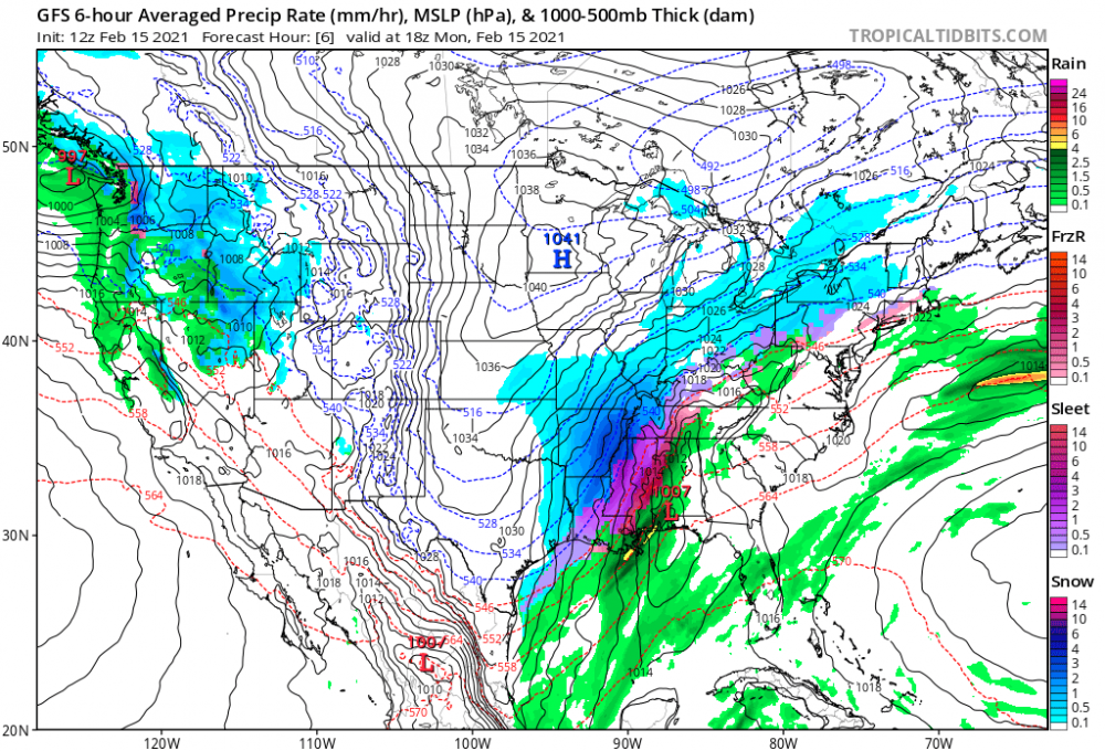
-
Back to Back Major Synoptic Snowstorms!
LakeEffectKing replied to BuffaloWeather's topic in Upstate New York/Pennsylvania
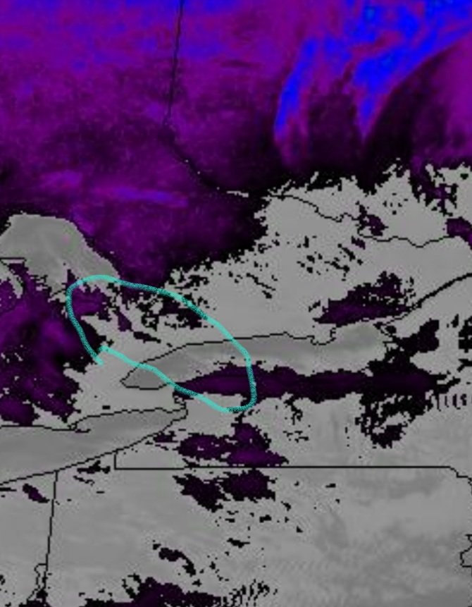
Front is east of current modeling: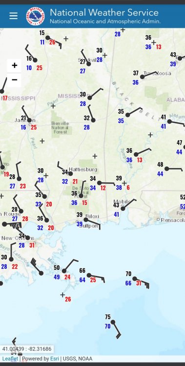
-
Back to Back Major Synoptic Snowstorms!
LakeEffectKing replied to BuffaloWeather's topic in Upstate New York/Pennsylvania
1st flakes are flying here in Bridgeport -
Back to Back Major Synoptic Snowstorms!
LakeEffectKing replied to BuffaloWeather's topic in Upstate New York/Pennsylvania
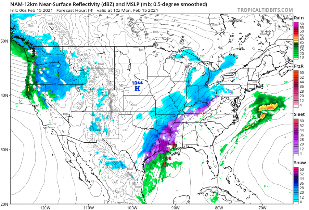
Nam initialized sn/sleet line wrong.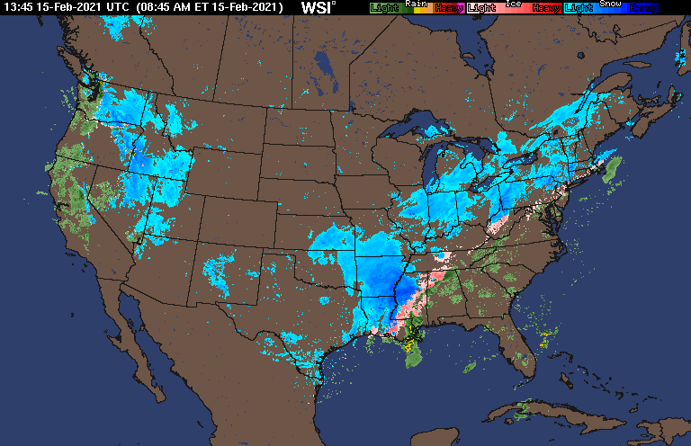
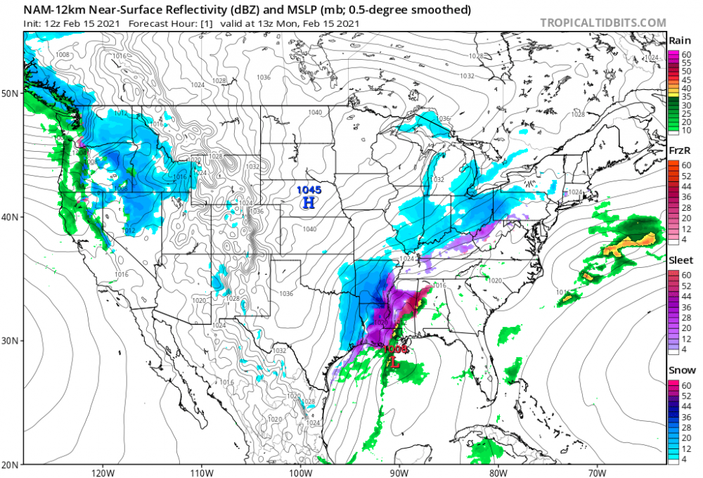
-
Back to Back Major Synoptic Snowstorms!
LakeEffectKing replied to BuffaloWeather's topic in Upstate New York/Pennsylvania
Based on viewing some upstream data, I feel somewhat confident that the models will tic back southeast with the snow/sleet line for late tonight...fingers crossed! -
Back to Back Major Synoptic Snowstorms!
LakeEffectKing replied to BuffaloWeather's topic in Upstate New York/Pennsylvania
Water pipes will be bursting everywhere. -
Back to Back Major Synoptic Snowstorms!
LakeEffectKing replied to BuffaloWeather's topic in Upstate New York/Pennsylvania
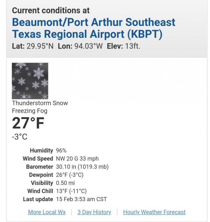
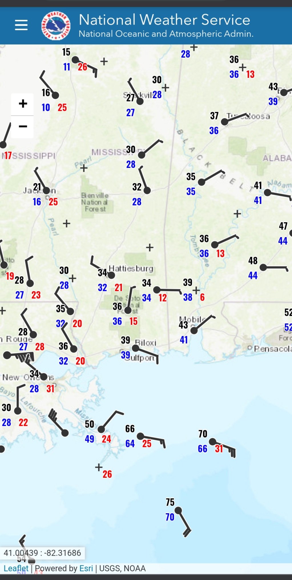
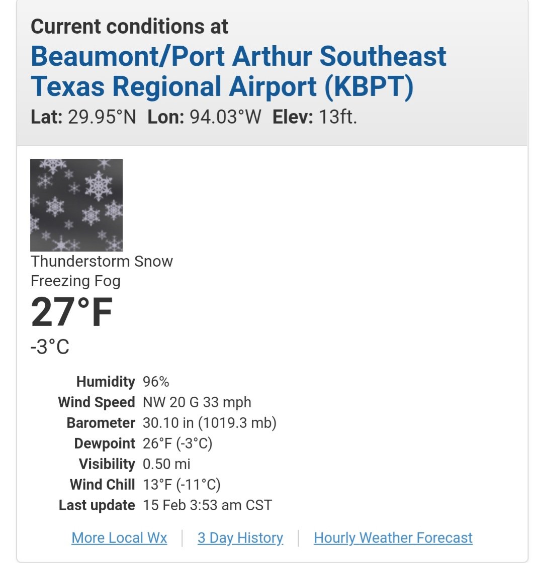
Obs from TX, LA, AR are pretty much all snow...Nam no clue..