
BlueRidgeFolklore
-
Posts
797 -
Joined
-
Last visited
Content Type
Profiles
Blogs
Forums
American Weather
Media Demo
Store
Gallery
Everything posted by BlueRidgeFolklore
-

2025-2026 Fall/Winter Mountain Thread
BlueRidgeFolklore replied to Buckethead's topic in Southeastern States
Happy to have ya! We’re a fairly level headed crew most days -
January 25/26 Jimbo Back Surgery Storm
BlueRidgeFolklore replied to Jimbo!'s topic in Southeastern States
I am not certain it's a north trend versus an expanding precip shield. As Eric Webb alluded to elsewhere, this is a massive arctic airmass we're dealing with and most models, especially the ICON, are likely underestimating the CAD. -
2025-2026 Fall/Winter Mountain Thread
BlueRidgeFolklore replied to Buckethead's topic in Southeastern States
When was the last time we saw a snow mean that high? 2017? -
2025-2026 Fall/Winter Mountain Thread
BlueRidgeFolklore replied to Buckethead's topic in Southeastern States
My goodness what a run! -
2025-2026 Fall/Winter Mountain Thread
BlueRidgeFolklore replied to Buckethead's topic in Southeastern States
I feel like we’ve seen this movie a dozen times. This will correct NW over the coming days. If you’re in the Southern Mountains from Highlands to Saluda, get ready. -
2025-2026 Fall/Winter Mountain Thread
BlueRidgeFolklore replied to Buckethead's topic in Southeastern States
Every community in the French Broad River valley is in a shitty place for snow. Haha. At the very least, Henderson County performs better with CAD events than it’s NWF counterparts. -
2025-2026 Fall/Winter Mountain Thread
BlueRidgeFolklore replied to Buckethead's topic in Southeastern States
I know Grand Highlands very well. I have family that live on Bearwallow, I used to ride my four wheeler through GH when it was a cow farm. Of course that was years ago! I wasn't far from Montclair back then, I was in PG County, living on Andrews AFB. We were at 80-90" as well. Best winter I've ever lived through! -
2025-2026 Fall/Winter Mountain Thread
BlueRidgeFolklore replied to Buckethead's topic in Southeastern States
Welcome! Sounds like you're near the Bat Cave / Bearwallow Mountain area. Bearwallow has been known for some good winter weather from time to time. Funny you mentioned the Mid-Atlantic forum, that was my first introduction to AmericanWx as well. Spent the 2010 Snowmageddon/Snowpocalypse blizzards in the DMV when I was in the Navy. Fun times! Welcome to the mountains, hopefully you brought the winter weather mojo with you! -
2025-2026 Fall/Winter Mountain Thread
BlueRidgeFolklore replied to Buckethead's topic in Southeastern States
The WPC just released their 3 month forecast for winter and it doesn't look good for us. https://x.com/NWSGSP/status/1978840883098202131 However, just out of curiosity and went back and looked at their forecast for the 2013-2014 since that seems to be the winter that is getting the most comparisons and the similarities are striking. Below is also how that winter faired for us.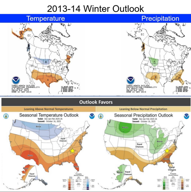
-
2025-2026 Fall/Winter Mountain Thread
BlueRidgeFolklore replied to Buckethead's topic in Southeastern States
It's coming! Of note, one of the analog years I keep seeing being mentioned for this upcoming winter is 2013-2014. That ended up being a good winter for us. KAVL temperatures for that October were relatively warm with mid-70's all the way into late October. Just something to keep an eye on.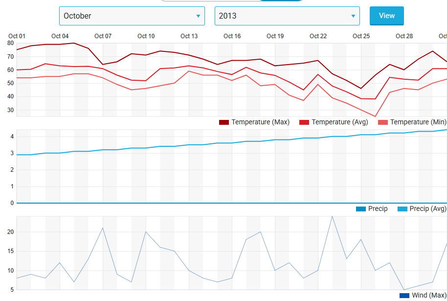
-
Mid to long range discussion- 2025
BlueRidgeFolklore replied to wncsnow's topic in Southeastern States
https://published.aer.com/aoblog/aoblog.html "Siberian snow cover got off to a quick start in September and that has continued into October (see Figure ii), however it seems to me the rapid advance of late September has slowed a bit in October. In fact in a bit f an unusual twist the surface temperatures have been more impressive this month (as in cold) than the snow cover, typically it is the reversed. Above normal Siberian snow cover extent (SCE) favors a weak polar vortex this winter and more widespread severe winter weather across the NH" -
2025-2026 Fall/Winter Mountain Thread
BlueRidgeFolklore replied to Buckethead's topic in Southeastern States
That's in line with climo, I'm taking it to the bank. -
2025-2026 Fall/Winter Mountain Thread
BlueRidgeFolklore replied to Buckethead's topic in Southeastern States
I've been here a long time and we've regularly dealt with tropical storm systems. Helene is and hopefully will always be the outlier. I can think back to Bill, Frances, Ivan, Arlene, Dennis, Fred, etc, and never do I remember waking up to such flooding and devastation before the system makes landfall in the Gulf. That's the one image that will always stand out to me with Helene, is the sheer amount of flooding we were already dealing with. Just an unfathomable set of circumstances. -
2025 Spring/Summer Mountain Thread
BlueRidgeFolklore replied to Maggie Valley Steve's topic in Southeastern States
Let's Go!!!! -
2025 Spring/Summer Mountain Thread
BlueRidgeFolklore replied to Maggie Valley Steve's topic in Southeastern States
It's September 4th, who's kicking off the new thread? -
2025 Spring/Summer Mountain Thread
BlueRidgeFolklore replied to Maggie Valley Steve's topic in Southeastern States
Wait until tomorrow! -
2025 Spring/Summer Mountain Thread
BlueRidgeFolklore replied to Maggie Valley Steve's topic in Southeastern States
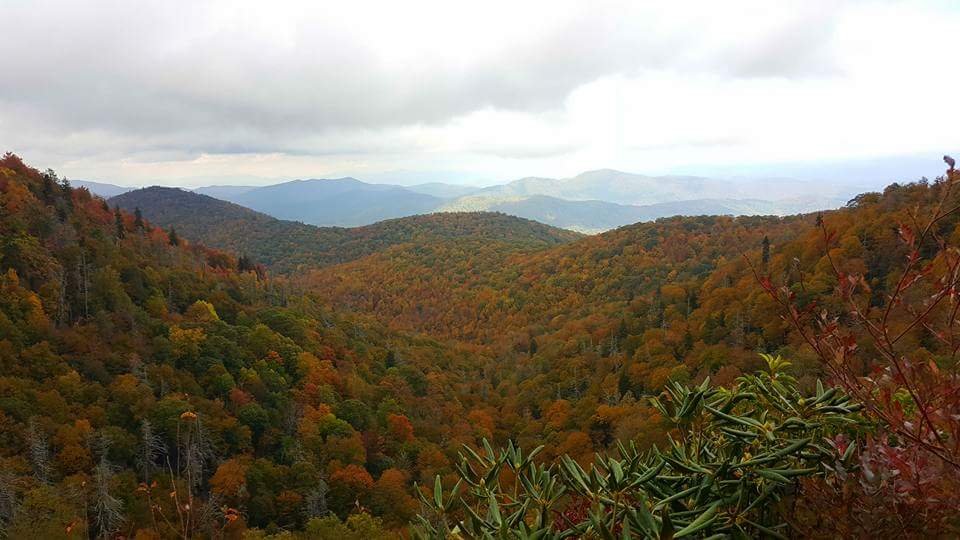
Looks like we might be in for a brief taste of fall. https://www.facebook.com/share/1FD9w4ijqg/?mibextid=wwXIfr -
2025 Spring/Summer Mountain Thread
BlueRidgeFolklore replied to Maggie Valley Steve's topic in Southeastern States
Definitely. Woke up to a hellacious storm in Henderson this morning. -
2025 Spring/Summer Mountain Thread
BlueRidgeFolklore replied to Maggie Valley Steve's topic in Southeastern States
Pretty weird seeing the Southern Escarpment so dry. -
2024-2025 Fall/Winter Mountain Thread
BlueRidgeFolklore replied to Buckethead's topic in Southeastern States
Pretty surreal map! -
February 19-20 Major Winter Storm Threat
BlueRidgeFolklore replied to NorthHillsWx's topic in Southeastern States
Lucky you, we got an entire truck load of Starlink delivered to us holler folk back during Helene. We get to be a thorn in your arse well into night. -
2024-2025 Fall/Winter Mountain Thread
BlueRidgeFolklore replied to Buckethead's topic in Southeastern States
The NAM just came in juicier than previous runs, for WNC. -
2024-2025 Fall/Winter Mountain Thread
BlueRidgeFolklore replied to Buckethead's topic in Southeastern States
Not at all! -
2024-2025 Fall/Winter Mountain Thread
BlueRidgeFolklore replied to Buckethead's topic in Southeastern States
Fellas, we might have something here! -
2024-2025 Fall/Winter Mountain Thread
BlueRidgeFolklore replied to Buckethead's topic in Southeastern States
Great place! Spent many a night at Peg Leg Petes and McGuire's


