
BlueRidgeFolklore
-
Posts
797 -
Joined
-
Last visited
Content Type
Profiles
Blogs
Forums
American Weather
Media Demo
Store
Gallery
Everything posted by BlueRidgeFolklore
-

2020/2021 Fall/Winter Mountain thread
BlueRidgeFolklore replied to Met1985's topic in Southeastern States
That tells me they’re skeptical of the details right now but that they need to get it posted. “Dusting to half a foot for 1/3rd of NC. Outside of that we’re really not sure.” Lol. -
2020/2021 Fall/Winter Mountain thread
BlueRidgeFolklore replied to Met1985's topic in Southeastern States
Couldn’t save AVL though. Lol. being sandwiched between the Black and Balsam mountains makes it a desert, comparatively speaking. -
2020/2021 Fall/Winter Mountain thread
BlueRidgeFolklore replied to Met1985's topic in Southeastern States
I was actually shocked to see it.... -
2020/2021 Fall/Winter Mountain thread
BlueRidgeFolklore replied to Met1985's topic in Southeastern States
I can be in Balsam Grove in roughly 30min, Little Canada is further. I expect that area to do really good.... -
2020/2021 Fall/Winter Mountain thread
BlueRidgeFolklore replied to Met1985's topic in Southeastern States
Looking at the Kuchera ratio is more realistic and personally, I feel is still too high, but I think the areas shown are the favored areas. Red circle is the highest elevation along the southern escarpment and will wring out plenty of moisture. Green circles on the map are the French Broad River Valley and the Pigeon River Gorge. Asheville is notorious for being a victim of downsloping in this setup. It's the same reason why it tends to be the driest area in NC and Transylvania county the wettest. Those Balsam Mountains are just a bear to overcome.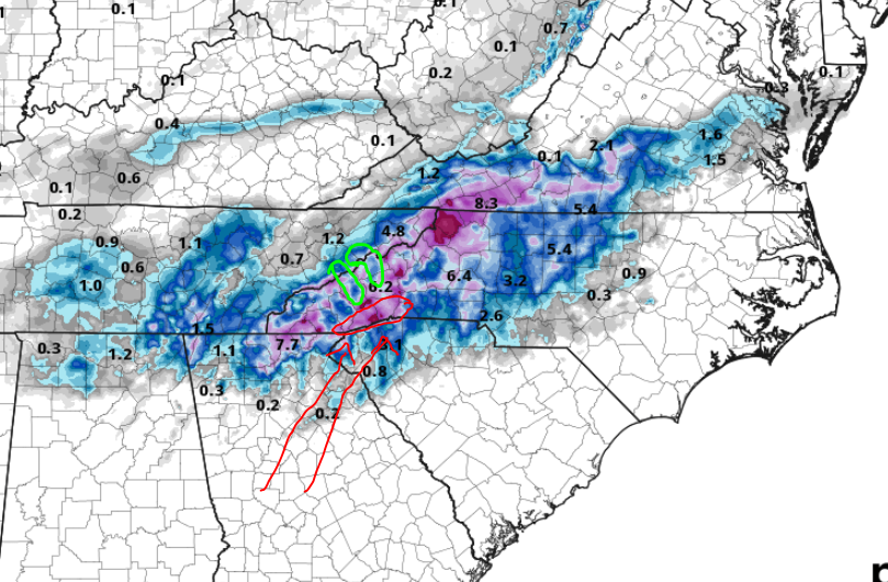
-
2020/2021 Fall/Winter Mountain thread
BlueRidgeFolklore replied to Met1985's topic in Southeastern States
No I am not, that is all public land up 276 from my side of the Parkway. I haven't seen anything in the models to indicate that moisture or temp will be an issue in Transylvania. Obviously being higher helps. My expectations are not on the totals the models are spitting out but I do fully expect accumulating snow as the signal on the models is too strong to expect otherwise. The 64 corridor from Highlands to Hendersonville has consistently been shown as a good spot for this storm. -
2020/2021 Fall/Winter Mountain thread
BlueRidgeFolklore replied to Met1985's topic in Southeastern States
Not if this becomes a predominantly upslope/downslope compounded event. Not much different than we see with NWF and snow holes on the leeward side of the of the TN/NC line. I expect the southern escarpment and the higher peaks to wring out the most moisture, and for there to be some lower totals within. I think some of the blue in Haywood County is due to downsloping from the Balsams from a storm of this setup. We shall see but I don't see anything inherently glaring from the 3k map that says we should toss. I am not expecting a foot of snow in those favored areas, but I do think they are favored areas. -
2020/2021 Fall/Winter Mountain thread
BlueRidgeFolklore replied to Met1985's topic in Southeastern States
While I agree, there has been a consistent storm signal for WNC. Amounts vary, but accumulating snow has been shown, run after run....... -
2020/2021 Fall/Winter Mountain thread
BlueRidgeFolklore replied to Met1985's topic in Southeastern States
3k NAM says someone better rent one of those yurts in DuPont....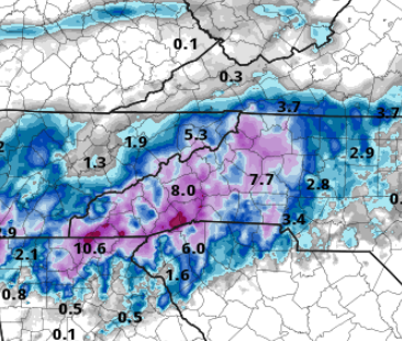
-
2020/2021 Fall/Winter Mountain thread
BlueRidgeFolklore replied to Met1985's topic in Southeastern States
Not a widespread even but could put up some locally high numbers along the southern mountains. I think areas like Balsam Gove could see upwards of 6". -
2020/2021 Fall/Winter Mountain thread
BlueRidgeFolklore replied to Met1985's topic in Southeastern States
The ICON looked good for the Southern Escarpment and NW mountains as well. I'll be interested in seeing the 3km soon.......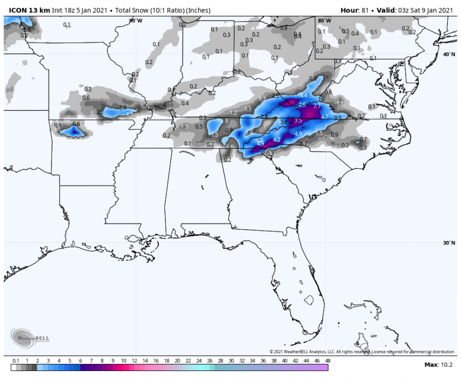
-
2020/2021 Fall/Winter Mountain thread
BlueRidgeFolklore replied to Met1985's topic in Southeastern States
Maybe so for some areas but I expect the southern escarpment will wring out some decent QPF with upsloping. Highlands to Hendersonville should do well. -
2020/2021 Fall/Winter Mountain thread
BlueRidgeFolklore replied to Met1985's topic in Southeastern States
Not sure this storm will put out a 10:1 ratio but it'll be a good thump nonetheless. -
2020/2021 Fall/Winter Mountain thread
BlueRidgeFolklore replied to Met1985's topic in Southeastern States
Yes sir, that's one thing I have always loved about the mountain thread over the years. No overhyping storms, no meltdowns, level heads just taking it for what it is. -
2020/2021 Fall/Winter Mountain thread
BlueRidgeFolklore replied to Met1985's topic in Southeastern States
Heaviest frost of the year this morning down in Henderson County. Looked like a good dusting of snow when I first got up. I haven't seen frost lay this heavy on paved surfaces in a while. The roads were soaked from the melt off.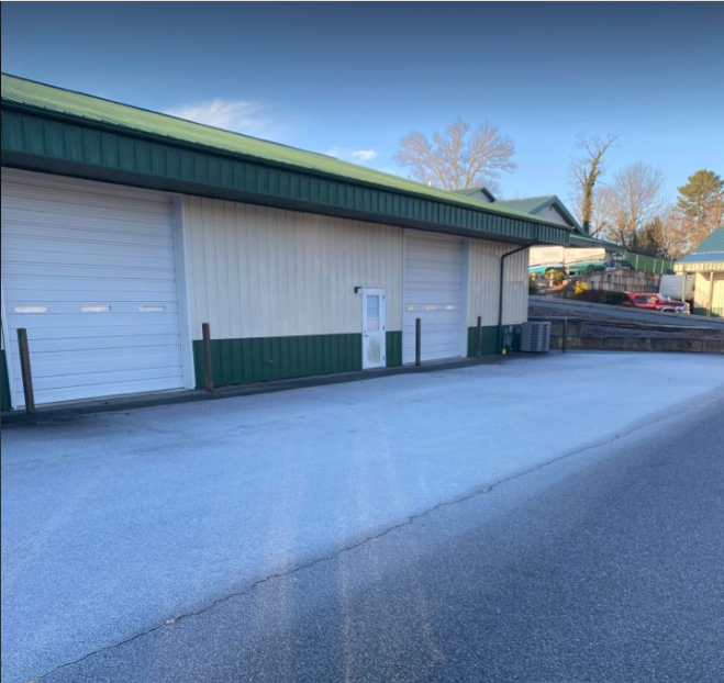
-
2020/2021 Fall/Winter Mountain thread
BlueRidgeFolklore replied to Met1985's topic in Southeastern States

-
2020/2021 Fall/Winter Mountain thread
BlueRidgeFolklore replied to Met1985's topic in Southeastern States
Needs more agreement, I agree. -
2020/2021 Fall/Winter Mountain thread
BlueRidgeFolklore replied to Met1985's topic in Southeastern States
Winter storm tracking brings everyone back like a good ol' fashioned homecoming. -
2020/2021 Fall/Winter Mountain thread
BlueRidgeFolklore replied to Met1985's topic in Southeastern States
This is what always sticks out in my mind about those hurricanes. https://www.weather.gov/gsp/PeeksCreek -
2020/2021 Fall/Winter Mountain thread
BlueRidgeFolklore replied to Met1985's topic in Southeastern States
Frances and Ivan in '04 was an absolute mess up here! -
2020/2021 Fall/Winter Mountain thread
BlueRidgeFolklore replied to Met1985's topic in Southeastern States
It will be close. A gullywasher is a'comin. -
2020/2021 Fall/Winter Mountain thread
BlueRidgeFolklore replied to Met1985's topic in Southeastern States
Agreed but we can never have too much cold air building to our north. Looks like we'll rely on wedge fronts for reprieve during an overall warm pattern in November. I'll take that. -
2020/2021 Fall/Winter Mountain thread
BlueRidgeFolklore replied to Met1985's topic in Southeastern States
The 12z runs are saying not so fast on a warm November, at least the start of it. -
2020/2021 Fall/Winter Mountain thread
BlueRidgeFolklore replied to Met1985's topic in Southeastern States
Not necessarily a bad thing if you want cold around Christmas, as I've been alluding to. Eventually the teleconnections will lead to a cold pattern for us at some point, as we've seen this fall. When you look back at last year and how we got cold toward the middle to end of October, we ultimately went into November colder than we left it, which carried into a scorcher of a December. It's been a great fall, I think I can sacrifice a November for a good pattern flip coming in the dead of winter.
-
2020/2021 Fall/Winter Mountain thread
BlueRidgeFolklore replied to Met1985's topic in Southeastern States
This is a 180 from last fall where it was warm early, got cool toward the end of October through Mid-November and then flipped back to warm for December where we were in the mid-60s on Christmas. I can handle a warm (relative) November if in exchange we get a true fall and Christmas (one of which has already verified). Let's hope this warmth is a good thing.