
BlueRidgeFolklore
-
Posts
797 -
Joined
-
Last visited
Content Type
Profiles
Blogs
Forums
American Weather
Media Demo
Store
Gallery
Everything posted by BlueRidgeFolklore
-

2023 Mountains Spring/Summer Thread
BlueRidgeFolklore replied to Tyler Penland's topic in Southeastern States
It’s October 1st, who’s firing up the Fall/Winter thread? Can’t be me! -
2023 Mountains Spring/Summer Thread
BlueRidgeFolklore replied to Tyler Penland's topic in Southeastern States
WLOS tryin' to get the juices flowing around here. https://wlos.com/news/local/noaa-predicts-el-nio-to-bring-increased-snowfall-to-western-carolinas-this-winter?fbclid=IwAR0S1czHOl8ohB7VkqAPQKI22jFZayiVgQLBkxtQKGIjaIr_NdUJF1eyOrY -
2023 Mountains Spring/Summer Thread
BlueRidgeFolklore replied to Tyler Penland's topic in Southeastern States
You aren’t kidding! Need some different mojo this year! -
2023 Mountains Spring/Summer Thread
BlueRidgeFolklore replied to Tyler Penland's topic in Southeastern States
Bout time to fire up the fall/winter thread! -
2022-2023 Fall/Winter Mountains Thread
BlueRidgeFolklore replied to BlueRidgeFolklore's topic in Southeastern States
How I feel right now: -
2022-2023 Fall/Winter Mountains Thread
BlueRidgeFolklore replied to BlueRidgeFolklore's topic in Southeastern States
Yep! Didn’t have to deer hunt in my parka once this year but you can bet your sweet @$$ I’ll need it for Turkey season. -
2022-2023 Fall/Winter Mountains Thread
BlueRidgeFolklore replied to BlueRidgeFolklore's topic in Southeastern States
There’s a weenie in all of us. -
2022-2023 Fall/Winter Mountains Thread
BlueRidgeFolklore replied to BlueRidgeFolklore's topic in Southeastern States
-
2022-2023 Fall/Winter Mountains Thread
BlueRidgeFolklore replied to BlueRidgeFolklore's topic in Southeastern States
Sweet setup! Love the Kifaru bag. Which gaiters are you wearing? -
2022-2023 Fall/Winter Mountains Thread
BlueRidgeFolklore replied to BlueRidgeFolklore's topic in Southeastern States
Yep, I remember mid-70's and near 80's up until mid to late October. Seem to flip cool around the week of Halloween if I am remembering correctly. -
2022-2023 Fall/Winter Mountains Thread
BlueRidgeFolklore replied to BlueRidgeFolklore's topic in Southeastern States
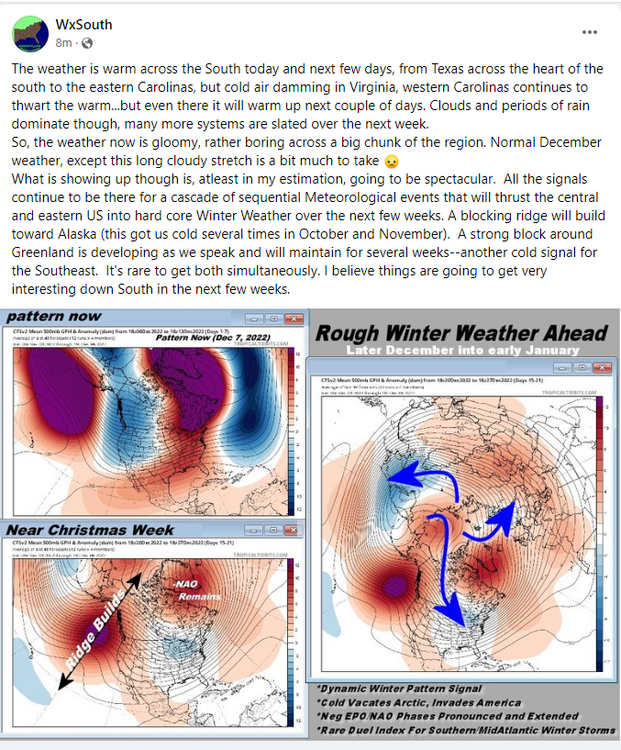
Agreed. Going to be a lot of waffling in the near future. I do have my eyes on Fiona. -
2022-2023 Fall/Winter Mountains Thread
BlueRidgeFolklore replied to BlueRidgeFolklore's topic in Southeastern States
I'm ready! -
I am getting a jump on Meteorological Fall by a couple days. Figured we could spend the early part discussing the tropics and potential impacts here in the mountains.
-
2021-2022 Fall/Winter Mountains Thread
BlueRidgeFolklore replied to BlueRidgeFolklore's topic in Southeastern States
I'm ready to track sunny and 75. Haha! -
2021-2022 Fall/Winter Mountains Thread
BlueRidgeFolklore replied to BlueRidgeFolklore's topic in Southeastern States
Yea, just a passing glance but it looked like it had little to no ensemble support on either model. Going to be an interesting few days. -
January 20-22 “bring the mojo” winter storm threat
BlueRidgeFolklore replied to lilj4425's topic in Southeastern States
My guess is that they believe the NW shift is inevitable. Webber has been hinting all day that there’s nothing to stop it and it’s more likely to happen than not. Going to be an interesting 48hrs, no doubt. -
2021-2022 Fall/Winter Mountains Thread
BlueRidgeFolklore replied to BlueRidgeFolklore's topic in Southeastern States
72hrs out. Let see what happens. -
2021-2022 Fall/Winter Mountains Thread
BlueRidgeFolklore replied to BlueRidgeFolklore's topic in Southeastern States
For real. I’m not worried about the CMC or Ukie with the big dogs in our corner. -
2021-2022 Fall/Winter Mountains Thread
BlueRidgeFolklore replied to BlueRidgeFolklore's topic in Southeastern States
Sorry, but I’m greedy -
2021-2022 Fall/Winter Mountains Thread
BlueRidgeFolklore replied to BlueRidgeFolklore's topic in Southeastern States
Jim Cantore spotted in Hendersonville.
-
2021-2022 Fall/Winter Mountains Thread
BlueRidgeFolklore replied to BlueRidgeFolklore's topic in Southeastern States
Chris Justus saying he’s not changing his forecast. -
2021-2022 Fall/Winter Mountains Thread
BlueRidgeFolklore replied to BlueRidgeFolklore's topic in Southeastern States
What do you think is causing the short range models to struggle with this? -
2021-2022 Fall/Winter Mountains Thread
BlueRidgeFolklore replied to BlueRidgeFolklore's topic in Southeastern States
There you go! Boom! -
2021-2022 Fall/Winter Mountains Thread
BlueRidgeFolklore replied to BlueRidgeFolklore's topic in Southeastern States
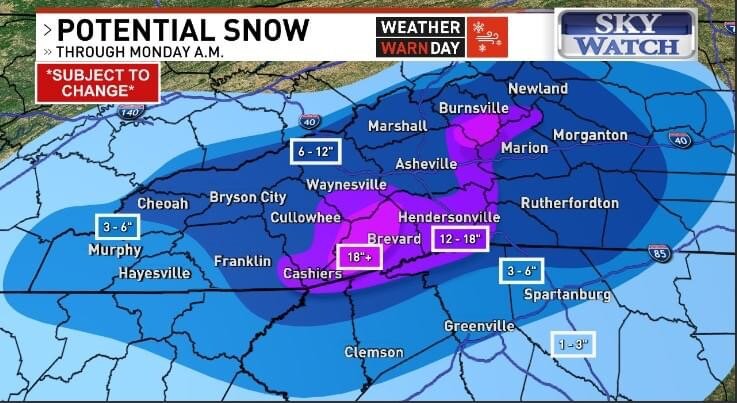
Not for the mountains. Actually bumped up from this morning.
-
2021-2022 Fall/Winter Mountains Thread
BlueRidgeFolklore replied to BlueRidgeFolklore's topic in Southeastern States
Jason looked at this thread (me specifically) and said “keep talkin’ that sh*t” touché