
BlueRidgeFolklore
-
Posts
797 -
Joined
-
Last visited
Content Type
Profiles
Blogs
Forums
American Weather
Media Demo
Store
Gallery
Everything posted by BlueRidgeFolklore
-

2021-2022 Fall/Winter Mountains Thread
BlueRidgeFolklore replied to BlueRidgeFolklore's topic in Southeastern States
Those numbers went up for the southern escarpment. -
2021-2022 Fall/Winter Mountains Thread
BlueRidgeFolklore replied to BlueRidgeFolklore's topic in Southeastern States
It’s not a trend. NWS had a disco earlier where they were confident the LP was heading towards 95, not taking a dip in Lake Chatuge. NAM is struggling to resolve this for some reason. -
2021-2022 Fall/Winter Mountains Thread
BlueRidgeFolklore replied to BlueRidgeFolklore's topic in Southeastern States
Like clockwork, CAD appears stronger as well. -
2021-2022 Fall/Winter Mountains Thread
BlueRidgeFolklore replied to BlueRidgeFolklore's topic in Southeastern States
Man, where did @HurricaneTracker go? Haven’t seen him in a while! -
2021-2022 Fall/Winter Mountains Thread
BlueRidgeFolklore replied to BlueRidgeFolklore's topic in Southeastern States
Been like that forever, hence why we start a Mountain Thread every year. -
2021-2022 Fall/Winter Mountains Thread
BlueRidgeFolklore replied to BlueRidgeFolklore's topic in Southeastern States
Safe bet. 6” increments gives a ton of room for variation. -
2021-2022 Fall/Winter Mountains Thread
BlueRidgeFolklore replied to BlueRidgeFolklore's topic in Southeastern States
Depends on the setup but that feature nearly always shows up in the models with CAD setups and it’s not simply a snow hole in AVL but a stretch of lower totals extending the entire river valley from Madison into Buncombe. Makes sense, all the cold air is dammed up along the eastern escarpment, so any access to the warmer air west of the Apps would cut totals. Obviously the higher elevations in this region still do well. -
2021-2022 Fall/Winter Mountains Thread
BlueRidgeFolklore replied to BlueRidgeFolklore's topic in Southeastern States
To hell with the cashier, I’m hitting the express self checkout. -
2021-2022 Fall/Winter Mountains Thread
BlueRidgeFolklore replied to BlueRidgeFolklore's topic in Southeastern States
CJ upped his totals after GSP posted some bullish numbers.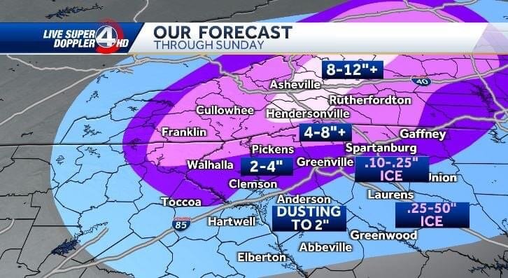
-
2021-2022 Fall/Winter Mountains Thread
BlueRidgeFolklore replied to BlueRidgeFolklore's topic in Southeastern States
Go up to Bearwallow for Blizzard conditions -
2021-2022 Fall/Winter Mountains Thread
BlueRidgeFolklore replied to BlueRidgeFolklore's topic in Southeastern States
That “V” of lower totals on the GFS coming into Asheville from Madison County, is due to the French Broad River Valley funneling in warmer air from TN. That’s always a battleground area with CAD. In these setups, AVL isn’t Black Mountain. Black Mountain will do well. -
2021-2022 Fall/Winter Mountains Thread
BlueRidgeFolklore replied to BlueRidgeFolklore's topic in Southeastern States
CAD is almost always underdone at this range. As Ward and others have said, this will likely get corrected as we get closer. -
2021-2022 Fall/Winter Mountains Thread
BlueRidgeFolklore replied to BlueRidgeFolklore's topic in Southeastern States
Jason Boyer after seeing the 6z Euro. (I kid, I kid)
-
2021-2022 Fall/Winter Mountains Thread
BlueRidgeFolklore replied to BlueRidgeFolklore's topic in Southeastern States
Jason always takes an indifferent stance with these storms. Give his followers just enough to understand that there is a major winter storm coming, but backs off just short of going all in to save himself the humiliation and ire if it all goes wrong. If you forecast 6” and get 12”, what wonderful surprise. If you forecast 12” and get 5”, it’s pitchforks and bayonets. -
2021-2022 Fall/Winter Mountains Thread
BlueRidgeFolklore replied to BlueRidgeFolklore's topic in Southeastern States
Just saw his post. Mind boggling to say the least. -
2021-2022 Fall/Winter Mountains Thread
BlueRidgeFolklore replied to BlueRidgeFolklore's topic in Southeastern States
64 Special incoming. From Hendo to Brevard up to Toxaway, Cashiers, Highlands and Franklin. I can see 15+ in some of the higher elevations around there. -
2021-2022 Fall/Winter Mountains Thread
BlueRidgeFolklore replied to BlueRidgeFolklore's topic in Southeastern States
She’s a beaut Clark.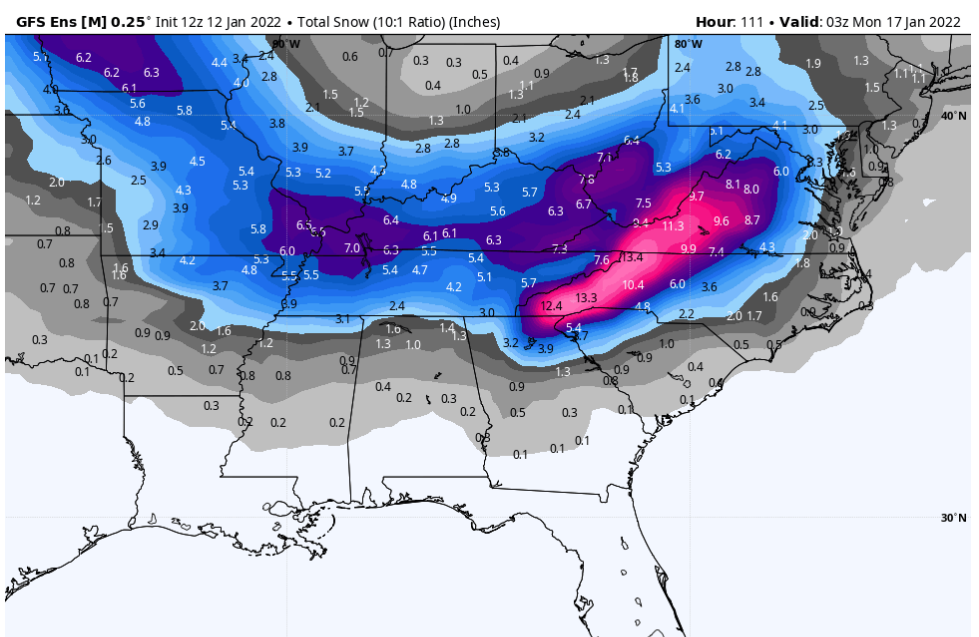
-
2021-2022 Fall/Winter Mountains Thread
BlueRidgeFolklore replied to BlueRidgeFolklore's topic in Southeastern States
Me too. CAD should likely trend stronger as we get closer. There is no doubt that we’re about to get walloped. -
2021-2022 Fall/Winter Mountains Thread
BlueRidgeFolklore replied to BlueRidgeFolklore's topic in Southeastern States
Great Googly Moogly! -
2021-2022 Fall/Winter Mountains Thread
BlueRidgeFolklore replied to BlueRidgeFolklore's topic in Southeastern States
I’ve noticed on the latest HRRR and NAM runs for that area around KAVL, it wants to bleed cold air down the river valley into Henderson County. You might get a surprise! -
2021-2022 Fall/Winter Mountains Thread
BlueRidgeFolklore replied to BlueRidgeFolklore's topic in Southeastern States
Anyone seeing flurries this AM? -
2021-2022 Fall/Winter Mountains Thread
BlueRidgeFolklore replied to BlueRidgeFolklore's topic in Southeastern States
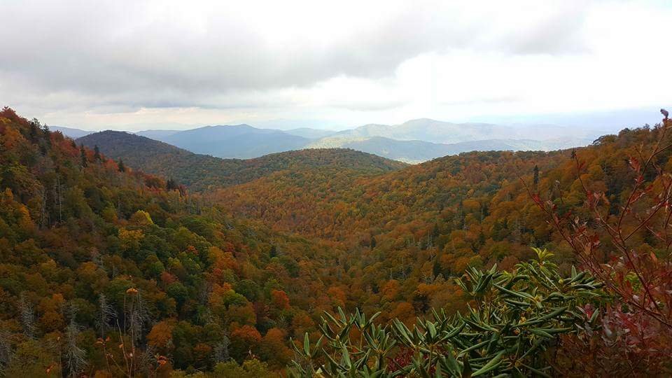
Fall is about to make a grand entrance this weekend! -
2021-2022 Fall/Winter Mountains Thread
BlueRidgeFolklore replied to BlueRidgeFolklore's topic in Southeastern States
Welcome to October, gents. -
2021-2022 Fall/Winter Mountains Thread
BlueRidgeFolklore replied to BlueRidgeFolklore's topic in Southeastern States
-
2021-2022 Fall/Winter Mountains Thread
BlueRidgeFolklore replied to BlueRidgeFolklore's topic in Southeastern States
I sat on a horseshoe, hung a Dreamcatcher on the monitor and held a rabbits foot in my hand, as I started this thread.


