
BlueRidgeFolklore
-
Posts
797 -
Joined
-
Last visited
Content Type
Profiles
Blogs
Forums
American Weather
Media Demo
Store
Gallery
Everything posted by BlueRidgeFolklore
-

2020/2021 Fall/Winter Mountain thread
BlueRidgeFolklore replied to Met1985's topic in Southeastern States
I’ll leave the mocking to flatlanders, we welcome any blue that wants to show up on a map, no matter how far out. -
2020/2021 Fall/Winter Mountain thread
BlueRidgeFolklore replied to Met1985's topic in Southeastern States
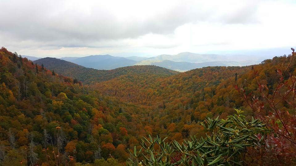
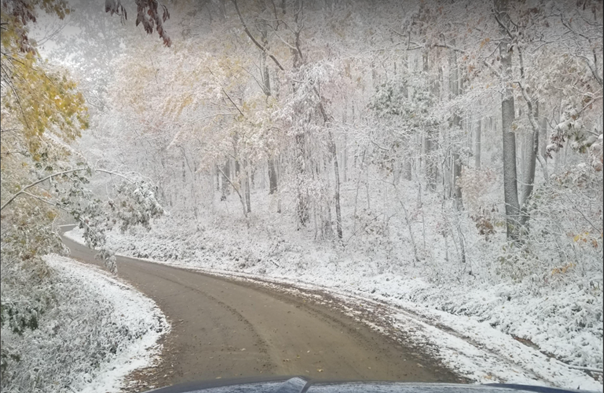
Seems about correct to see the first flakes begin to fly. My wife's birthday is at the end of October and we always find ourselves chasing a few token flakes around that time. These were taken in 2017, which I find similar to 2020. Both were Nina years, both were wet from Summer to Early Fall, both were good color years and both seem to be trending towards a cold ending in October. I am not sure how that fares for winter, I honestly can't remember how the 2017 winter unfolded. These were taken on October 29th. We started in Bethel, NC and ended up finding snow near Max Patch.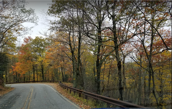
-
2020/2021 Fall/Winter Mountain thread
BlueRidgeFolklore replied to Met1985's topic in Southeastern States
Exit 20 on I-40, turn onto Cove Creek Rd and follow the signs. -
2020/2021 Fall/Winter Mountain thread
BlueRidgeFolklore replied to Met1985's topic in Southeastern States
This is a little lower elevation than Banner Elk or Wolf Laurel but Maples are turning like crazy here, very vibrant. Oaks and Poplars beginning the transition. Can definitely see the oranges, yellows and browns beginning to pop through the sea of green. Plenty of leaves in the road too. This was earlier coming down the mountain in Transylvania County. -
2020/2021 Fall/Winter Mountain thread
BlueRidgeFolklore replied to Met1985's topic in Southeastern States
I was up there Sunday. Color is starting to pop through. Not sure how the weather is going to be there this weekend however. Keep an eye out! -
2020/2021 Fall/Winter Mountain thread
BlueRidgeFolklore replied to Met1985's topic in Southeastern States
Maples and poplars are turning by the day. -
2020/2021 Fall/Winter Mountain thread
BlueRidgeFolklore replied to Met1985's topic in Southeastern States
Looking good. Definitely looks, especially in the valleys. This week should really send it into hyperdrive. -
2020/2021 Fall/Winter Mountain thread
BlueRidgeFolklore replied to Met1985's topic in Southeastern States
It is west, but ENC and the Piedmont appear to the take the brunt of the rain right now. It'll be interesting to see if the westward trend continues however. -
2020/2021 Fall/Winter Mountain thread
BlueRidgeFolklore replied to Met1985's topic in Southeastern States
The only way to coexist is to accept what bears do. They don't have the ability to reason, they don't know that your car, your house, your bird feeders, your trash are off limits. To them, they're just trying to survive and it's free game! Bear populations have exploded in the mountains because hardly anyone is hunting them anymore and until bear hunters are welcome again, it will continue to explode and human/bear interactions will continue to increase. That's just the harsh truth. -
2020/2021 Fall/Winter Mountain thread
BlueRidgeFolklore replied to Met1985's topic in Southeastern States
-
2020/2021 Fall/Winter Mountain thread
BlueRidgeFolklore replied to Met1985's topic in Southeastern States
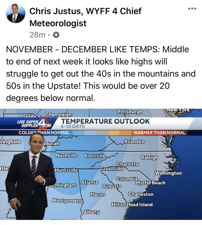
Not WNC, but interesting nonetheless: -
2020/2021 Fall/Winter Mountain thread
BlueRidgeFolklore replied to Met1985's topic in Southeastern States
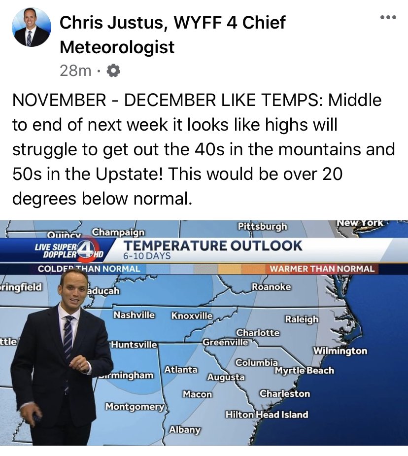
If this verifies and we can ride this pattern into mid-October, there's a good chance we could see our first flakes flying in the higher elevations in less than a month. I've seen it a few of times in my lifetime here.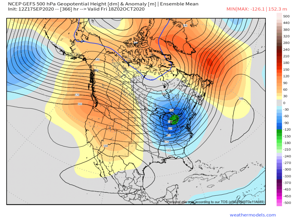
-
2020/2021 Fall/Winter Mountain thread
BlueRidgeFolklore replied to Met1985's topic in Southeastern States
Gut feeling based on years past but I believe we're finally going to get a real fall this year. -
2020/2021 Fall/Winter Mountain thread
BlueRidgeFolklore replied to Met1985's topic in Southeastern States
We're officially heading toward a La Nina winter. That's not a bad thing for the mountains (obviously El Nino didn't do anything for us last year) depending on it's strength. We've had some decent La Nina winters in the last decade. -
2020/2021 Fall/Winter Mountain thread
BlueRidgeFolklore replied to Met1985's topic in Southeastern States
Looks like today and tomorrow could be the last days in the 80's for the majority of the mountains. -
2020/2021 Fall/Winter Mountain thread
BlueRidgeFolklore replied to Met1985's topic in Southeastern States
I ain't mad. -
2020/2021 Fall/Winter Mountain thread
BlueRidgeFolklore replied to Met1985's topic in Southeastern States
I honestly think it'll land somewhere between. Seasonal and dry. I'll take that. -
2020/2021 Fall/Winter Mountain thread
BlueRidgeFolklore replied to Met1985's topic in Southeastern States
-
December 8-10, 2018 Winter Storm
BlueRidgeFolklore replied to Orangeburgwx's topic in Southeastern States
My comment was a general response to the discussion not a counter to any specifics. -
December 8-10, 2018 Winter Storm
BlueRidgeFolklore replied to Orangeburgwx's topic in Southeastern States
From Highlands to Hendersonville are going to get lambasted. -
December 8-10, 2018 Winter Storm
BlueRidgeFolklore replied to Orangeburgwx's topic in Southeastern States
They're showing more for Salisbury than atop Mt. Mitchell. I'm sorry, but there is no on this earth that I am going to buy into that map right now. -
December 8-10, 2018 Winter Storm
BlueRidgeFolklore replied to Orangeburgwx's topic in Southeastern States
The main point is that there is ZERO guidance that even suggests it at this point. -
December 8-10, 2018 Winter Storm
BlueRidgeFolklore replied to Orangeburgwx's topic in Southeastern States
Heck, the NAM just showed a thump here. There is no way that can be right. No way! -
December 8-10, 2018 Winter Storm
BlueRidgeFolklore replied to Orangeburgwx's topic in Southeastern States
I'm going with 2000', right along the escarpment. -
December 8-10, 2018 Winter Storm
BlueRidgeFolklore replied to Orangeburgwx's topic in Southeastern States
They were bullish for WNC in January 2016 storm but even then the totals crept up as we got closer. I don't think it's wishcasting to say these totals will go up when the Euro is showing 12" probabilities for KAVL at 100%. My gut just tells me based off experience, that these (for the Mountains only) are their conservative numbers.