The 4 Seasons
-
Posts
7,985 -
Joined
-
Last visited
Content Type
Profiles
Blogs
Forums
American Weather
Media Demo
Store
Gallery
Everything posted by The 4 Seasons
-
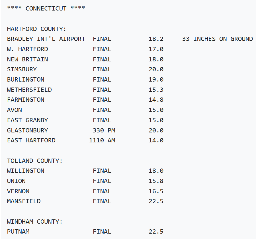
The official number for BDL for that storm is 12.3" in the climo data. The PNS has 20.3 lol, which i threw out. I'm just using whats in the F6 which is 12.3 for that date. So do you think i should or should not use E. Granby for BDL from that period 96-00 when BDL is missing? It sounds like the answer is no.
-
it's just they release these to the public whom take this very literally.
-
well this didn't age well
-
advisory is an average of 3" over a county and warning is 6". For Litchfield it's 4 and 7" respectively.
-
Yep, i noticed that as well. Winthrop COOP was identical to BOS in virtually every event. Same thing with BDR for a long time, over a decade. The Trumbull COOP was identical to BDR which means the BDR ob was not taken in Stratford itself i guess and actually in Trumbull? Or vice versa. It's impossible for me to know for sure where these obs are taken at each airport and how they've moved or changed over the years, so i just place the ob right over the town that the airport is in and for BDL that's Windsor Locks and BDR is Stratford.
-
Yeah, would way rather have it this way than the other. On paper 17-18 was good but the majority of the snow fell from Feb-Apr. Same with 04-05. 10-11, 13-14 and 20-21...also very good winters that had a dead March. Last good March we had was 2019 that was right at the beginning. 2018 was the last real banger.
-
really? that's a high bar. I think i got the significant wording from the benchmark that the NWS has used forever. 6+ = warning snowfall and the wording in the watches and warnings usually includes "significant". And before they switched to "light, moderate, heavy" accumulations in the zones it used to be "significant" for anything that would meet warning criteria. So i personally use moderate for advisory and significant for warning level or higher which that storm in Dec definitely was. It's all subjective and personal opinion though.. Yeah Jan 03 sucked here, there was a tight gradient in CT though. Similar to the christmas blizzard. Dec 03 and Jan 05 i lump into the same bucket of a long duration shredded radar mess. They were both pretty bad. Dec 05 was wild but still way better out east about 6-12 for most of CT
-
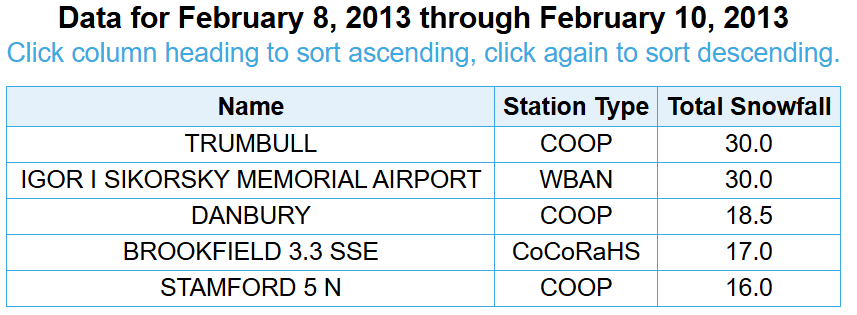
A little late past the anniversary but i updated the pi-day blizzard as well as Dec 2009 and Jan 21-22 2014 with new snowfall maps
-
i dunno Will seems to think that they are definitely for BDL, at least most of them he said. When i was reading old PNS they would sometimes state "within 2mi of major airports". So i guess the observers had to be within 2 miles of the airport itself as a requirement.
-
I feel like every time we're under a warning winds under perform and don't meet criteria and the one time we're under an advisory we get to widespread warning
-
I've seen more bears in this area than i've seen in my entire life. In the past two years i spotted a bear or a pair of two at least 5 times and the 30 years before that i've never seen a single one.
-
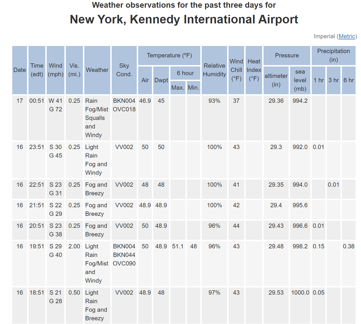
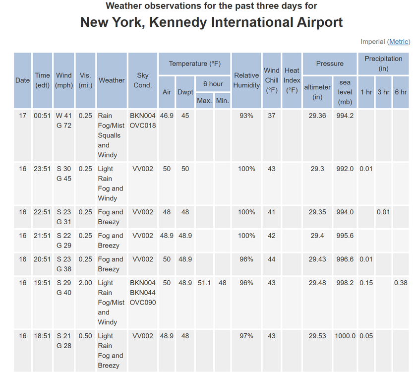
Impressive 72 gust at JFK METAR KJFK 170451Z 25036G63KT 1/4SM R04R/P6000FT RA BR SQ BKN004 OVC018 08/07 A2936 RMK AO2 PK WND 22063/0444 SFC VIS 6 RAE02B35 PRESRR SLP942 P0000 T00830072 401110072
-
i just saw that, wow impressive sustained too. Definitely feels like there should be a HWW up and not advisories. METAR KJFK 170451Z 25036G63KT 1/4SM R04R/P6000FT RA BR SQ BKN004 OVC018 08/07 A2936 RMK AO2 PK WND 22063/0444 SFC VIS 6 RAE02B35 PRESRR SLP942 P0000 T00830072 401110072
-
Well thats whats in the official, set in stone records so i have to use it if im going to highlight the airports on the map. A lot of them are wonky, not just BDL, and not just for the late 90s or 00s. People claim a lot of the NYC data is low, as recent as the blizzard of 2026, but it kinda is what it is. And BDR is notoriously low. yea i remember the blizz of 16 was very low for DCA.
-
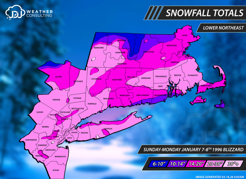
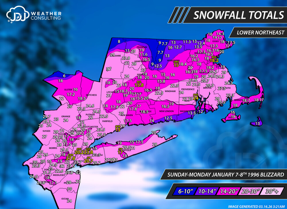
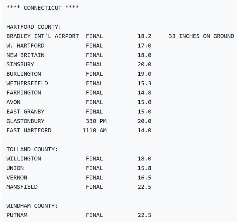
I just updated the Blizzard of '96 with new maps as well a couple others. I made significant changes to these maps with new reports from the OPU. Mostly the contours/numbers went way up especially for CT/SE MA. It's funny that the PNS/OPUs from around this time, mostly older 90s and 00s, often do not match up with what's in the nowdata (F6). I'm always going to default to what's in the official record books but it makes me wonder sometimes if those numbers are the mistakes and not the PNS. This is another instance where BDL is way off from the F6. BDL on the OPU is 18.2 which seems about right but the F6 is 15.8". Also, i think BDR is totally ridiculous. 15" when all the surrounding reports are around 2 feet. So i'm supposed to believe that BDR got 5" more in the Blizzard of 26 than 96? There's no shot 2026 eclipsed 1996 there, and by 5 inches.
-
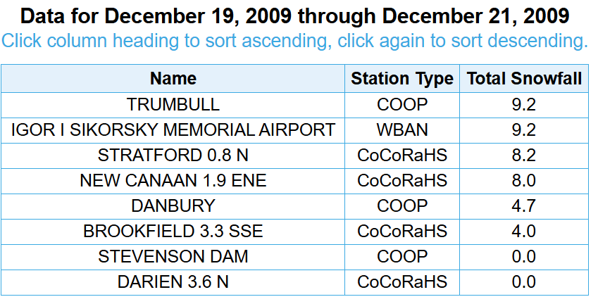
Darn I just finished that. What about Dec 19 20 2009?
-
@Ginx snewx would you happen to have a snowfall total recorded for Jan 7-8 1996? I dunno how far your records go back but you gave me Dec 2000 so i thought maybe you might have one.
-
Yeah I was looking at Iron Mountain. They are gonna get whacked. Historic blizzard
-
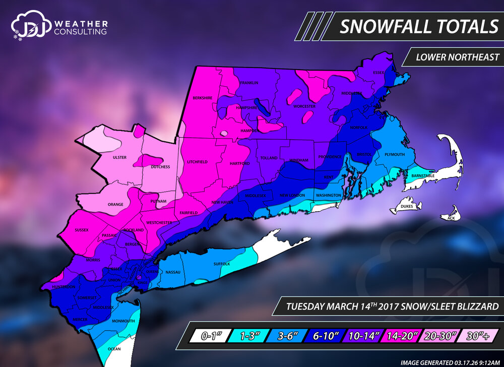
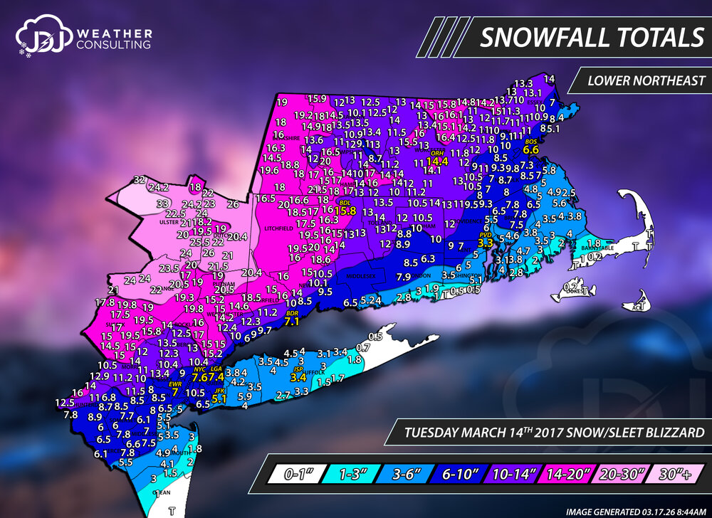
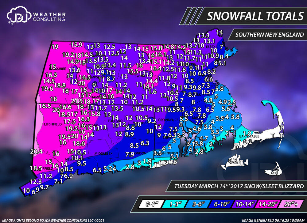
9 years ago today. The Pi-Day blizzard. It was forecast to track near or just inside the BM a couple days out but it was one of those storms that kept inching toward the coast until it's eventual hugger track right over E LI and GON. Blizzard warnings were up for the NYC area into southern New England which were all eventually cancelled and areas further inland were upgraded to blizz warnings. Forecast snow amounts were historic levels around 18-24"+ for coastal areas but a quick changeover to IP cut amounts way back to less than 10 for most areas along 95. Historic level snowfall occurred well inland in upstate new york around the Catskills and capital region with 30-50" in some spots. This was some of the heaviest snow and snow/sleet I've ever seen in the early morning hours of the 14th with rates around 4" per hour. Picked up 9.5" here in just a few hours. I wil eventually get to remapping this and including a Lower Northeast view. https://www.jdjweatherconsulting.com/mar-14-2017
-
historic storm for the UP, i was looking at some of the warnings there, 1-3 feet..20-32". Impressive, considering they just a 6-12 dump.
-
Yeah I know that's what I been using for years to find all the products for the archive, probably the most active bookmark I have. BTW I credited all you guys for your help at the bottom of the archive main page
-
Well it looks like we found an answer to no PNS from BOX pre 1997.. it's there just under a different product name OPU. I just checked jan 1996 is there, Feb 1995 is there. Thanks to @vortex95for that. Big help. Looks like I'll have to go back and re do all the storms pre 1997 that I didn't have BOX and ALY PNS for which will help a lot. They are all on the IEM site.
-
Thanks I didn't know that I'll take a look. Do those exist for BOX for the 95-96 season? Specially jan 1996 blizzard? If they do I'll have to redo a lot of those events pre 1997 or so
-
It's here: https://www.jdjweatherconsulting.com/historic-storms That's what the historic storms section is for (one reason anyway) for big storms pre-1994. I'm going to go back and touch it up at some point. The reason i stopped at 94-95 is because NEXRAD WSR-88D is unavailable before Jan 1, 1995. So i stopped the seasons at 94-95. Technically there is one event in the 94-95 season, Nov 1994 that doesnt have radar because of that fact. On top of that there is no PNS reports from around 95-97 and earlier depending on the forecast office so reports are thin and it's basically just COOP data so i dont really feel that good about the maps before that time...they are rough and coarse. Thanks. I do the best i can with hand made maps, it's never going to be perfect and there will always be small discrepancies depending on what reports you use or keep out. I try to use every resource available and throw out the bad data. It's all just one persons interpretation thats why you're never going to see two maps that look identical to each other for the same storm. The best ones are the computer generated ones that get fed data and spit out a hi resolution contoured map and factor in terrain. Tomer Burg probably has the best maps out there in my opinion. The NWS maps are also great but they don't filter out a lot of obviously bad data that gets ingested.
-
Only 7 months to go..