The 4 Seasons
-
Posts
7,720 -
Joined
-
Last visited
Content Type
Profiles
Blogs
Forums
American Weather
Media Demo
Store
Gallery
Everything posted by The 4 Seasons
-

Clipper Fires In Wednesday Feb 25 Disco/ Obs
The 4 Seasons replied to Damage In Tolland's topic in New England
I have more snow so far this season than i've had in the last 3 winters combined, says a lot. -
Clipper Fires In Wednesday Feb 25 Disco/ Obs
The 4 Seasons replied to Damage In Tolland's topic in New England
morning -
Clipper Fires In Wednesday Feb 25 Disco/ Obs
The 4 Seasons replied to Damage In Tolland's topic in New England
.gif.d4d0e9a9df9e127c544220e95a9cdf85.gif)
-
Clipper Fires In Wednesday Feb 25 Disco/ Obs
The 4 Seasons replied to Damage In Tolland's topic in New England
Dropped down to single digits here but already shooting up fast to around 20.gif.6527549c5fc42b5f69da6a006ccef33a.gif)
-
So we shouldn't be forecasting 15-20" in weather apps and snowfall maps yet?
-
Clipper Fires In Wednesday Feb 25 Disco/ Obs
The 4 Seasons replied to Damage In Tolland's topic in New England
.gif.1d033f530ee6671ce4ce8acf4c4c3623.gif)
-
I think theres a couple people here in Belchertown if you see this and a report that would help
-
Thank you, i have a question there is a Sherman 1.2E that came in with 22" and a 4N New Fairfield that has 21" on the interactive map. I am assuming the 4N New Fairfield is you? Are you also the Sherman one in cocorahs or is that someone different? They are very close to each other and often can be labeled differently on different reporting systems. I'm going to assume they are not the same until i hear otherwise. thanks.
-
"Don’t do it" 2026 Blizzard obs, updates and pictures.
The 4 Seasons replied to Ginx snewx's topic in New England
Where were they before Taunton? They moved to Norton several years ago. I read the observers are supposed to be within a 2mi radius of the airport, not sure if thats true or still the case. Just something i saw on old PNS going back into the 90s. -
Best run of the GEFS so far.
-
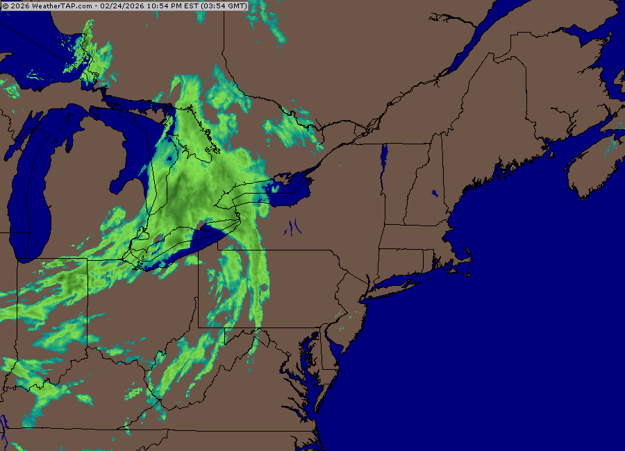
Clipper Fires In Wednesday Feb 25 Disco/ Obs
The 4 Seasons replied to Damage In Tolland's topic in New England
Radar looks a lot healthier than the HRRR would suggest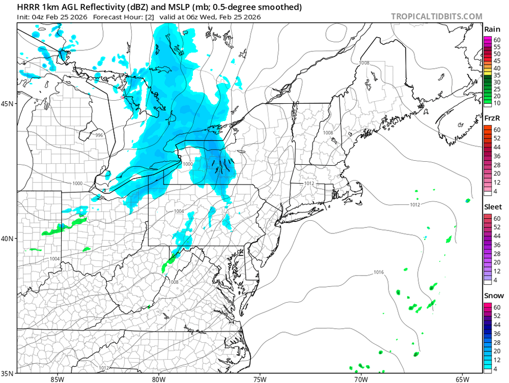
-
Clipper Fires In Wednesday Feb 25 Disco/ Obs
The 4 Seasons replied to Damage In Tolland's topic in New England
Though i think most will end up in the 1-2 range. 2-3 will be the exception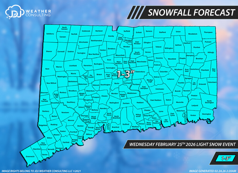
-
"Don’t do it" 2026 Blizzard obs, updates and pictures.
The 4 Seasons replied to Ginx snewx's topic in New England
-
"Don’t do it" 2026 Blizzard obs, updates and pictures.
The 4 Seasons replied to Ginx snewx's topic in New England
you should email that guy and tell him to make another one -
"Don’t do it" 2026 Blizzard obs, updates and pictures.
The 4 Seasons replied to Ginx snewx's topic in New England
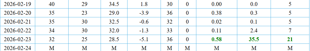
Well the depth of 21" makes total sense since those are measured at 7AM daily, and that's about right for the timing of the storm. 35.5" is total snowfall for the calendar day. And ASOS is not very good in high wind. If you go back and look at all the climo sites for 2022 and 2015 and others youll see the same thing. No clue why they don't use SWE from a core sample, but OceanStateWX said it, ASOS is king. -
55 to -58 would be something to behold. Who could pull off something like that? International Falls?
-
So ORH got 16.2? the PNS says 13.7 but that seems way off considering they got 13.9 just on the 23rd alone and 2.3 on 22nd. Thats what the CF6 shows. @ORH_wxman
-
"Don’t do it" 2026 Blizzard obs, updates and pictures.
The 4 Seasons replied to Ginx snewx's topic in New England
Time for a handle change TauntonBlizzard2026 2013 has nothing on this, what was that like 2 feet, pffft -
"Don’t do it" 2026 Blizzard obs, updates and pictures.
The 4 Seasons replied to Ginx snewx's topic in New England
I've been saying this. And yes a lot of high wind blizzards look just like this with "30-70:1 ratios" It's bad. Just doing a core sample and manually changing the data would fix it. -
"Don’t do it" 2026 Blizzard obs, updates and pictures.
The 4 Seasons replied to Ginx snewx's topic in New England
king dong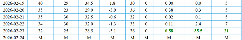
-
F storm F Winter F F F F F F
-
15.6 is super early too at 10:45AM. it was still snowing well after that. ill just use yours
-
its getting tossed, i have no idea why they included it. Nothing around it supports that kind of amount. Could just be a mis-entry
-
I just didn't understand why you said "Ryan's" like that was his map, what does Ryan have to do with that map?
-
Ryan who? I posted this on the first page, first post.