
The 4 Seasons
-
Posts
7,722 -
Joined
-
Last visited
Content Type
Profiles
Blogs
Forums
American Weather
Media Demo
Store
Gallery
Everything posted by The 4 Seasons
-

“Cory’s in NYC! Let’s HECS!” Feb. 22-24 Disco
The 4 Seasons replied to TheSnowman's topic in New England
I wouldn't take anything the nam is throwing out at 48 hours even remotely seriously let alone 84. It's pretty similar to 00Z however. On the other hand 6z rgem is nice throws a lot of qpf back west. Looks a tick NW from 00Z just glancing at it -
“Cory’s in NYC! Let’s HECS!” Feb. 22-24 Disco
The 4 Seasons replied to TheSnowman's topic in New England
I didn't think anyone would think that I took that seriously. Yeah it's obviously an error, grids are all fucked up in BOX. Anyway.. -
“Cory’s in NYC! Let’s HECS!” Feb. 22-24 Disco
The 4 Seasons replied to TheSnowman's topic in New England
Monsoon coming? Rain for the next 8 days in the PC -
Glad I went lean for CT probably would go down further but not gonna bother for that sliver in N CT
-
“Cory’s in NYC! Let’s HECS!” Feb. 22-24 Disco
The 4 Seasons replied to TheSnowman's topic in New England
Me too. 24 hour interval polygon sharp lines and mslp only. Almost useless. It's kinda like how we have the JMA now. I remember looking at Feb 2006 and being like oh that's a blizzard that's nice and moved on back to the NCEP site. -
“Cory’s in NYC! Let’s HECS!” Feb. 22-24 Disco
The 4 Seasons replied to TheSnowman's topic in New England
Either way I like the idea of only 2X/day I wonder how others feel about that. Maybe just the have the high res stuff run 4X/day. I kinda miss when the Euro only ran twice per day. The only main global that was running four times was the GFS. Now it's everything even the Canadian and UK run 4 times now in short range -
Up in Torrington, definitely. With temps locked below freezing the whole duration and snow, sleet, freezing rain i'd expect secondary roads to be messy that are untreated. It's not going to be the worst storm in the world but definitely a problem for the AM commute well inland in Litchfield Co. I'd probably expect some delays. But you know the deal, treated main roads and highways will be mostly fine. Snow/Sleet/Ice should be over by the AM commute and anything that falls as a mix will have changed back over to light snow/flurries by then. The bulk of it should be over after midnight.
-
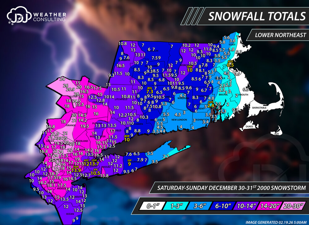
Just finished updating the 3rd of the big 3 storms of Winter 2000-2001. This was another pita early 2000s storm with terrible PNS data and reports but not nearly as bad as Mar 2001. Didn't change all that much but now we have a new northeast view. NYC seems low and a bit odd that its a foot on the nose considering surrounding reports. Everything else seems somewhat reasonable. Was able to plug in additional reports from the Weathernet6 archive. https://www.jdjweatherconsulting.com/dec-30-31-2000
-
did you have a map/call for yesteryda? i felt like i was very conservative from what i saw out there and was too high
-
I wanted to honestly take this but i got a 1/3rd of the way through after 15 or 20 minutes and i was like yeah F this. This is way too long of a survey to expect people to deal with. NWS Jan 25-26th, 2026 Snowstorm Survey
-
“Cory’s in NYC! Let’s HECS!” Feb. 22-24 Disco
The 4 Seasons replied to TheSnowman's topic in New England
Feb 1.. looks familiar... -
First and probably last call unless something major changes. Another garbage nuisance event round here
-
“Cory’s in NYC! Let’s HECS!” Feb. 22-24 Disco
The 4 Seasons replied to TheSnowman's topic in New England
we're screwed -
“Cory’s in NYC! Let’s HECS!” Feb. 22-24 Disco
The 4 Seasons replied to TheSnowman's topic in New England
It's only the Euro that i give that kind of weight to. If it was the GFS, CMC, UK or something stupid like the Icon id hit the ignore button. -
“Cory’s in NYC! Let’s HECS!” Feb. 22-24 Disco
The 4 Seasons replied to TheSnowman's topic in New England
right -
Wednesday Feb 18 Mixed event. NOPE …ain’t happenin’
The 4 Seasons replied to HoarfrostHubb's topic in New England
i fixed it -
Wednesday Feb 18 Mixed event. NOPE …ain’t happenin’
The 4 Seasons replied to HoarfrostHubb's topic in New England
Still got about 6 weeks left to get this Mon storm, Mar 1993, Mar 1888, Apr 1997 and May 1977 -
Wednesday Feb 18 Mixed event. NOPE …ain’t happenin’
The 4 Seasons replied to HoarfrostHubb's topic in New England
As long as you're closer to 100 -
Wednesday Feb 18 Mixed event. NOPE …ain’t happenin’
The 4 Seasons replied to HoarfrostHubb's topic in New England
Did anybody get anything? -
just updated it, replaced the image on the previous page
-
“Cory’s in NYC! Let’s HECS!” Feb. 22-24 Disco
The 4 Seasons replied to TheSnowman's topic in New England
Yeah i saw that on MLs well into the Berks. QPF doesn't reflect that well with a hole over the CTRV, if only that can hold or improve would be nice -
“Cory’s in NYC! Let’s HECS!” Feb. 22-24 Disco
The 4 Seasons replied to TheSnowman's topic in New England
i'll never understand this mentality, so you'd rather have 0" than 6 because your neighbor gets more/buried? If that verified verbatim i'd be more than happy with 7 inches if Coastal gets 18" and a full blizz. I'd be jealous but certainly wouldn't trade it for P. Sunny. Another warning event is a win -
“Cory’s in NYC! Let’s HECS!” Feb. 22-24 Disco
The 4 Seasons replied to TheSnowman's topic in New England
Looks like the whole cluster on the 6Z GEFS shifted NW -
“Cory’s in NYC! Let’s HECS!” Feb. 22-24 Disco
The 4 Seasons replied to TheSnowman's topic in New England
The Euro has been adamantly stubborn, so well see if it ever catches on, or we reach a middle ground somewhere SE of the BM that teases everyone. -
“Cory’s in NYC! Let’s HECS!” Feb. 22-24 Disco
The 4 Seasons replied to TheSnowman's topic in New England
not happening james


