Drummer
-
Posts
48 -
Joined
-
Last visited
Content Type
Profiles
Blogs
Forums
American Weather
Media Demo
Store
Gallery
Everything posted by Drummer
-

January 30th- Feb 1st ULL and coastal storm obs
Drummer replied to JoshM's topic in Southeastern States
about 2in in lake wylie as of 15mins ago, coming down good. Roads are a mess, but Food Lion was pretty busy about an hour ago. -
The “I bring the mojo” Jan 30-Feb 1 potential winter storm
Drummer replied to lilj4425's topic in Southeastern States
In CLT suburbs. Will be sharing with my wife for....reasons. She will likely respond with the confidence reading. -
Southern Crippler - Get well soon Jimbo Storm Obs
Drummer replied to BooneWX's topic in Southeastern States
Lake Wylie. 0.25-0.5in of sleet, after an initial round of very light freezing rain after midnight. Waiting on the bigger round but kids and dog are enjoying. . -
Southern Crippler - Get well soon Jimbo Storm Obs
Drummer replied to BooneWX's topic in Southeastern States
Lake Wylie/Clover. Just started with freezing rain. Phone says it's 24F. -
WTF do I need to do to see accumulating snow again in CLT? JFC .
-
Sheesh. Last time Mrs Drummer saw 12in in CLT was 2014 before we had kids and had three date nights.
-
Same - specifically and only over the grounds of the US Whitewater Center in CLT so that I don't have to run a 50k trail race.
-
If we could get something that dumps a boatload of rain in the CLT area around the weekend of 10/4, that would be perfect. I have a 50k ultramarathon on what I have now learned is a really difficult course that I'd rather not have to attempt.
-
February 19-20 Major Winter Storm Threat
Drummer replied to NorthHillsWx's topic in Southeastern States
We kinda did, but it happens. . -
That was an odd cut to commercial on TWC. Looked like Bettes was taking some damage.
-
RIPIP .
-
Here we go. .
-
I’d really love for this thing to defy the odds and either fizzle out or curve north faster. currently at WDW until the 13th. Hopefully minimal impacts. Maybe some easement in the crowds and some ponchos.
-
at what point does the banter thread come into play around here?
-
Maybe just start with the letter B or C to offset the alphabet lol
-
[quote] 000 WTNT44 KNHC 281458 TCDAT4 Hurricane Ian Discussion Number 24 NWS National Hurricane Center Miami FL AL092022 1100 AM EDT Wed Sep 28 2022 Air Force Reserve and NOAA Hurricane Hunter data was absolutely critical this morning in diagnosing the rapid intensification of Ian, despite both planes undergoing multiple eyewall penetrations experiencing severe turbulence. That data supported an intensity of about 135 kt a few hours ago. Since that time, high-resolution Tampa Doppler radar data has been sampling the eyewall near 10,000 ft with winds up to 155 kt, indicating that Ian is on the threshold of category 5 status. The maximum winds are set to 135 kt on this advisory. Ian is expected to make landfall in southwestern Florida in the next few hours as a catastrophic hurricane. No changes were made to the track forecast near Florida, except to be faster to come into line with the latest consensus aids. One important change is that Ian is likely to remain more intact as it crosses the Florida peninsula (due to both its stronger initial wind speed and its faster forecast forward speed), and this now increases the threat of hurricane-force winds on the east coast of Florida. This necessitates the issuance of a Hurricane Warning on the east coast of central Florida. While significant re-strengthening of Ian might not occur over the Atlantic Ocean, model guidance has been catching up with a trough interaction from a shortwave over the southern United States, and are stronger than yesterday on Ian's intensity with more baroclinic forcing. Thus, a Hurricane Watch has been issued from northeastern Florida northward up the coast through most of coastal South Carolina. The new intensity forecast is raised from the previous one, near the latest statistical-dynamical guidance. Key Messages: 1. Catastrophic storm surge inundation of 12 to 18 feet above ground level along with destructive waves are expected somewhere along the southwest Florida coastline from Englewood to Bonita Beach, including Charlotte Harbor. Residents in these areas should urgently follow any evacuation orders in effect. 2. Catastrophic wind damage is beginning along the southwestern coast of Florida today near the landfall location. Hurricane-force winds are expected to extend well inland along near the core of Ian. Preparations to protect life and property should be urgently rushed to completion. 3. Heavy rainfall will spread across the Florida peninsula through Thursday and reach portions of the Southeast U.S. later this week and this weekend. Widespread, life-threatening catastrophic flooding is expected across portions of central Florida with considerable flooding in southern Florida, northern Florida, southeastern Georgia and coastal South Carolina. Widespread, prolonged major and record river flooding is expected across central Florida. 4. Hurricane conditions are expected along the east-central Florida coast overnight, where a Hurricane Warning has been issued. Hurricane conditions are possible from northeastern Florida to portions of South Carolina on Thursday and Friday, and a Hurricane Watch has been issued for that area. FORECAST POSITIONS AND MAX WINDS INIT 28/1500Z 26.3N 82.5W 135 KT 155 MPH 12H 29/0000Z 27.3N 82.1W 105 KT 120 MPH...INLAND 24H 29/1200Z 28.3N 81.4W 60 KT 70 MPH...INLAND 36H 30/0000Z 29.3N 80.8W 55 KT 65 MPH...OVER WATER 48H 30/1200Z 30.8N 80.6W 55 KT 65 MPH...OVER WATER 60H 01/0000Z 32.9N 80.9W 45 KT 50 MPH...INLAND 72H 01/1200Z 34.7N 81.5W 30 KT 35 MPH...POST-TROP/EXTRATROP 96H 02/1200Z 36.0N 81.5W 20 KT 25 MPH...POST-TROP/EXTRATROP 120H 03/1200Z...DISSIPATED $$ Forecaster Blake [/quote]
-
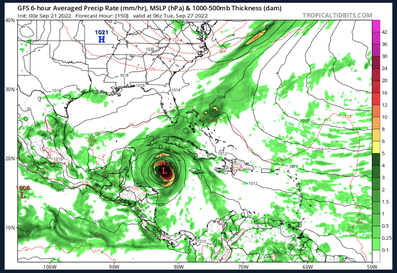
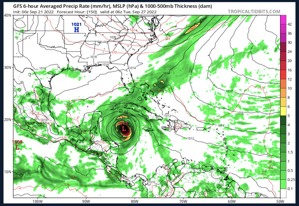
150
-
Seems like it might get cheese-grated over Hispanola on that track.
-
2022 Atlantic Hurricane season
Drummer replied to StormchaserChuck!'s topic in Tropical Headquarters
Do we have to do this? -
2022 Atlantic Hurricane season
Drummer replied to StormchaserChuck!'s topic in Tropical Headquarters
Thanks. Thought it looked kinda funky after watching the model run. -
2022 Atlantic Hurricane season
Drummer replied to StormchaserChuck!'s topic in Tropical Headquarters
ignoring any issues with initializing (haven't ran it myself), how accurate is this at 240hrs+? -
2022 Atlantic Hurricane season
Drummer replied to StormchaserChuck!'s topic in Tropical Headquarters
Great, you jinxed it. -
2022 Atlantic Hurricane season
Drummer replied to StormchaserChuck!'s topic in Tropical Headquarters
-
2022 Atlantic Hurricane season
Drummer replied to StormchaserChuck!'s topic in Tropical Headquarters
Even I, someone who wasn't gifted with much intelligence, knows not to call the season a "bust" or "boring" in early August. -
Very light snow falling in Lake Wylie