chubbs
Members-
Posts
4,066 -
Joined
-
Last visited
Content Type
Profiles
Blogs
Forums
American Weather
Media Demo
Store
Gallery
Everything posted by chubbs
-
Only Phoenixville and Spring City are NWS COOP stations and used by NCEI. The others are not used by NCEI.
-
Chester County PA - Analytical Battle of Actual vs. Altered Climate Data
chubbs replied to ChescoWx's topic in Climate Change
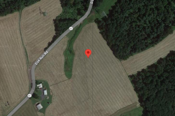
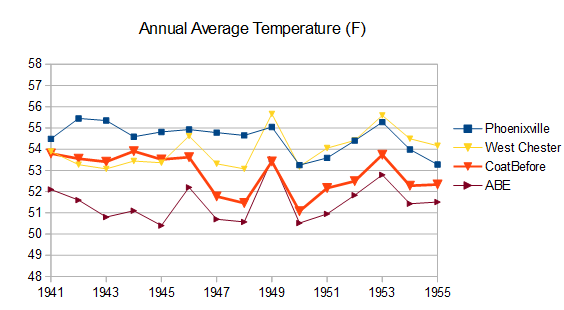
Once again you aren't addressing my criticism: the county stations have changed. According to NCDC here's the Coatesville station in 1945 and 1948. Big difference in local land-use on Chestnut St vs Doe Run Road. We don't have to guess or hand wave about the impact of the station moves. The nearby stations allow the impact to be determined. I have shown you the plots over and over again. Between 1945 and 1948 Coatesville cooled 2F relative to West Chester and other stations. The evidence is overwhelming. -
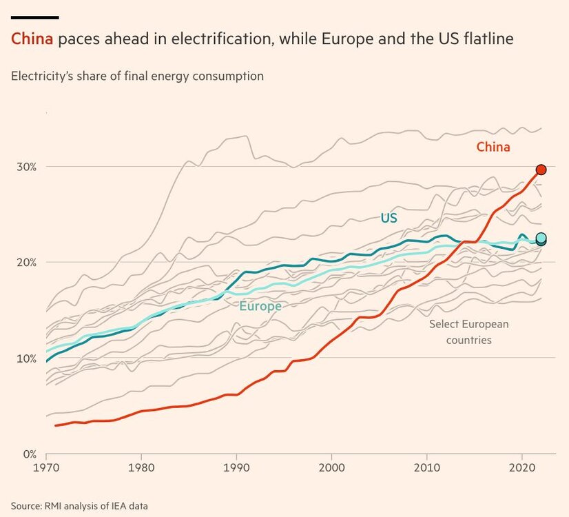
Here's another chart (from Financial Times) which shows how our fossil-fuel energy system is falling behind China's. Energy use and emissions are reduced with electricity due to higher end-use efficiency. For instance a gasoline car is 15-20% efficient while an EV has 90+% end-use efficiency.
-
Chester County PA - Analytical Battle of Actual vs. Altered Climate Data
chubbs replied to ChescoWx's topic in Climate Change
You aren't addressing my criticism. Yes, the new stations do a good job of covering the county, I never said they didn't. The problem is the older stations that make up the bulk of the county climate data. The older stations are located where people lived at the time: in towns, valleys, mainly in the east. We know the older stations are warm because when the Coatesville and West Chester stations moved a short distance to less built-up areas they cooled by roughly 2F. The DEOS stations that make up the bulk of your current station line-up are located in parks, nature preserves or similar, very different from the older coop stations. -
Most of those stations are giving you zero climate information because they don't have long records. Only Phoenixville has data before 2007.
-
The main point is that the stations have changed. Taking a simple average skews the data. The 1900 station network (City Of Coatesville, Kennett Square borough, West Chester Borough, and Phoenixville) is completely different than the current. Mainly towns in the early days. No towns now.
-
There were no stations in the northwest part of the county back in the day.
-
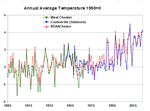
Here's another way of comparing NOAA to the raw data. Easy to normalize the data using a common year, 1950 in this case. This removes differences between stations to better isolate the long-term trend. Again NOAA and the raw data are in complete agreement on the long-term trend, roughly 4F of warming in Chesco.
-
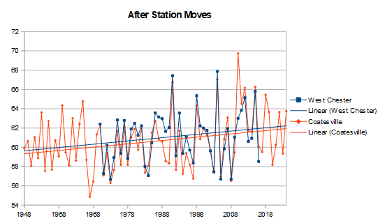
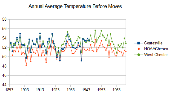
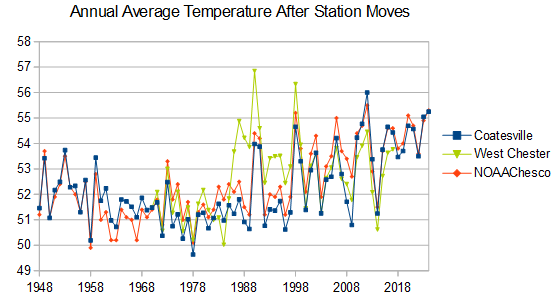
NOAA is in complete agreement with the raw data when you keep the station population constant and separate out the major station moves. Per chart above there are only a handful of long-term climate stations in Chester County. Both West Chester and Coatesville moved from towns to cooler rural locations and cooled by roughly 2F. It is easy to remove the station moves by plotting the before move and after move data separately. Before the moves West Chester and Coatesville are both about 2F warmer than NOAA.Not unexpected because these the town locations were warm sites, similar to Wilmington De. NOAA matches the year-to-year and long term trend of the before move data at both stations. After the stations moves, West Chester and Coatesville were more representative of the county close to NOAA . Like the before move data, NOAA matches the long-term trend and the year-to-year of the after move datra. The only exception is a warm spike at West Chester in the 1980s and 1990s. Which is clearly bad data. Chesco's claim that NOAA doesn't match the raw data is a complete strawman. He's the one who doesn't match the raw data. Why should NOAA match his faulty analysis?
-
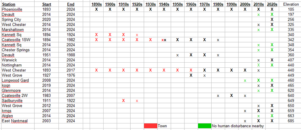
Here are the stations by year. What Chesco call's "Actual" is far from it. There is a big change in the station population from warm to cool, towns to rural, south and east to more centrally located, with more stations in the cooler north and west section. Most of the stations have short records and don't provide any climate info.
-
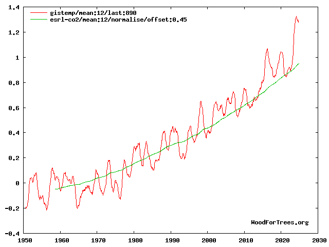
It's interesting to see the junk science/propaganda that circulates among climate deniers. Sure you can choose a yaxis that minimizes warming. Expanding the yaxis shows there's a close relationship between temperature and CO2. The chart is misleading for another reason. We are far from experiencing the full effect of CO2 yet. Temperature lags CO2 for 2 reasons: 1) It takes a long while to warm the ocean, melt ice sheets, shift forests etc.; and, 2) man-made aerosols have masked CO2 warming. Before 1970, aerosols masked almost all the warming from CO2. In the last 15 years we stepped-up the unmasking, mainly due to air pollution controls in China and on shipping, and temperature has responded. The other scientific message implicit in the denier chart. We don't need much of a rise in temperature to change our climate. A 1% change in absolute temperature will send us back tens of millions of years to a completely different world. Contradicts all the denier talking points which portray CO2 as a "trace" gas with minimal effect. The atmosphere already contains more than enough CO2 to change our climate.
-
Fusion could easily solve the climate crisis, the giant fusion reactor in the sky. Human power is roughly 1/100,000 of the energy available from the sun. Unfortunately China is getting close to the solar and battery finish line and we're not aware of the race.
-
Report: Another Year of Record Heat for the Oceans
chubbs replied to donsutherland1's topic in Climate Change
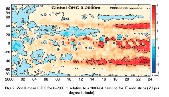
I wonder if Viterbo understood the paper. Virerbo's focuses on wind speed but the paper finds that the jet stream shifted not that winds are increased. Winds decreased in the subtropics and tropics between the two jet streams. Viterbo's bottom chart covers a very small part of the world (39.5-40.5 N, 70W - 10W) so also doesn't shed much light on the paper imo. There's some validity to the narrow baseline period comment. That ia a consequence of the relatively short period studied, 2000-2023. Means that the results are affected by decade-to-decade natural variability. That isn't surprising. The strong rate of warming in a narrow latitude zone is unusual and needed unusual conditions to develop. Note that a competing explanation for the recent mid-latitude ocean warming is a decrease in aerosol emissions. -
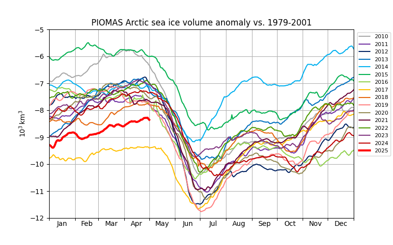
This year is #2 in sea ice volume at the start of the melt season, beyond 2017 another post nino year. Will need favorable weather, like 2017, to avoid a low September minimum.
-
Long-term temperature trends in the US are very well determined. There are thousands of stations and well proven methods for detecting non-weather-related station changes, heat islands, etc. 1970 was the only start date I had. Yes, warming would be a little less starting from 1950; but, warming would be even larger starting in 1900. Doubt the starting date would have much impact on the relative stance of the midwest, which is the point I was addressing.
-
Yes the NE coast and parts of the upper midwest have had increased snow since 1970. That's consistent with the paper I posted upthread (relinked below and added a second). As expected the snowfall signal is emerging much slower than the temperature signal due to offsetting precipitation and temperature effects and natural variability. https://journals.ametsoc.org/view/journals/clim/26/20/jcli-d-12-00832.1.xml https://agupubs.onlinelibrary.wiley.com/doi/pdfdirect/10.1029/2018GL079820
-
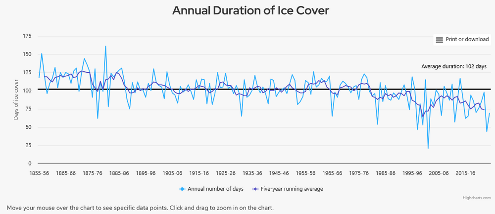
We've discussed the problem with comparing city and airport obs in Detroit and Chicago before. Need to maintain consistency or remove station changes to isolate the long-term climate trend. Winter warming has been uniform across the eastern US. If anything warming increases slightly from south to north. The fastest warming is in the upper midwest and northern New England. The warming map is confirmed by long-term data from Ann Arbor and lake freeze data from Mendota Lake in Madison Wisconsin.
-
Report: Another Year of Record Heat for the Oceans
chubbs replied to donsutherland1's topic in Climate Change
An interesting paper on the distribution of ocean warming. Particularly relevant to those living near 40N The world's oceans are heating faster in two bands stretching around the globe, one in the southern hemisphere and one in the north, according to new research led by climate scientist Dr Kevin Trenberth. In both hemispheres, the areas are near 40 degrees latitude. The first band at 40 to 45 degrees south is heating at the world's fastest pace, with the effect especially pronounced around New Zealand, Tasmania, and Atlantic waters east of Argentina.The second band is around 40 degrees north, with the biggest effects in waters east of the United States in the North Atlantic and east of Japan in the North Pacific. "This is very striking," says Trenberth,of the University of Auckland and the National Center of Atmospheric Research in Boulder, Colorado. "It's unusual to discover such a distinctive pattern jumping out from climate data," he says. The heat bands have developed since 2005 in tandem with poleward shifts in the jet stream, the powerful winds above the Earth's surface that blow from west to east, and corresponding shifts in ocean currents, according to Trenberth and his co-authors in the Journal of Climate. https://www.sciencedaily.com/releases/2025/05/250501122720.htm https://journals.ametsoc.org/view/journals/clim/38/9/JCLI-D-24-0609.1.xml -
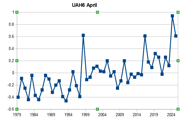
UAH6 tied for 3rd high this April, matching the 1998 and 2016 super ninos. Unusually warm for cool neutral enso.
-
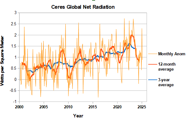
CERES data updated through February. Noisy from month to month. Last month's anomaly came in lower after an upward spike in January. The 12-month average is starting to turn up so the net radiation bottom for this enso cycle has probably been passed. If so net radiation fell to a similar level following the 2015/16 and 2023/24 ninos. The 3-year average remains stubbornly high, indicating that the next big step won't be cooler.
-
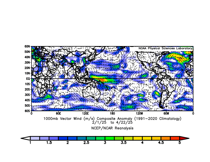
I haven't been following, but there have been unusually strong NE trades in the Atlantic MDR for the past 3 months which would cause upwelling. The mid-Atlantic subtropical ridge looks stronger than normal.
-
This 2013 paper on snowfall in the Northern Hemisphere is on track so far. Snow is expected to be a lagging indicator of climate change due to offsetting effects of precipitation and temperature and natural variability. Have to be well up in Canada, with average winter temps of -10C, to see a net snowfall benefit from warming. Further south, downward snowfall trends will emerge slowly as the Century progresses. Two steps down and one up kind of thing. https://journals.ametsoc.org/view/journals/clim/26/20/jcli-d-12-00832.1.xml
-
His comments are dumb. Shows he doesn't understand the climate system. Apologize for the complicated chart, which is from a recent paper on the causes of warming in the 23-24 nino. The ocean is being warmed from the surface down (bottom chart). The timing of surface ocean and atmosphere warming (AE is atmospheric energy in second chart from bottom) is modulated by enso. The warming of the ocean is due a global net radiation imbalance (second chart from top), which is also modulated by enso. Overall there's a balance between the net energy coming in at the top of the atmosphere and the amount of heat in ocean (see paper). No room for seismic energy to play a role as energy from the sun can explain all the ocean warming. Energy accumulates gradually in the ocean during La Nina and is partially released during el nino to upper ocean, atmosphere and space (outgoing radiation). During El nino net radiation falls (second chart from top) but only to the net balance line, i.e., the atmosphere can hold the added el nino heat it is receiving from the ocean. If the warming was due to seismic the added seismic energy would lead to a negative radiation imbalance as the added seismic heat would increase outgoing radiation. Note that the paper concludes that the increasing net radiation imbalance means we should expect a doubling of the rate of SST rise over the next 20 years. https://iopscience.iop.org/article/10.1088/1748-9326/adaa8a
-
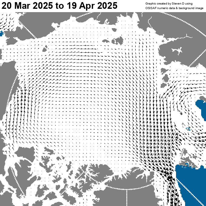
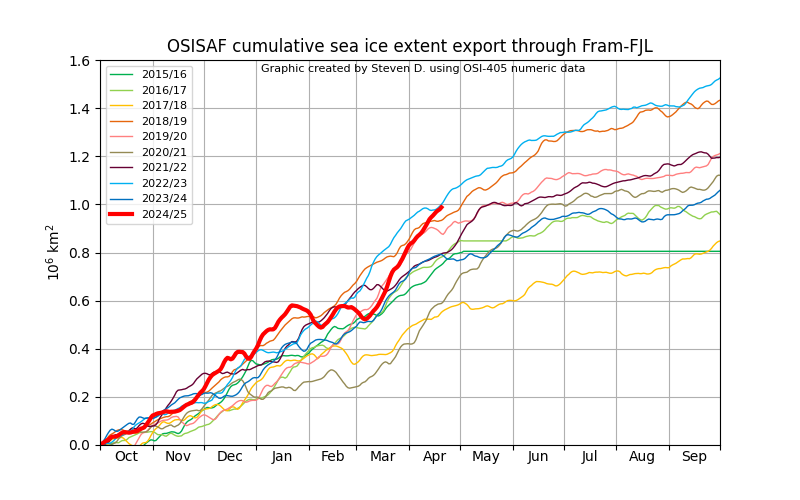
One factor is the pattern reversal along the Atlantic front in March. From warm compacting to cool exporting winds. While extent has expanded there is also high ice export through Fram and Franz Joseph straits. Pattern looks to continue for the next week. Note that this would be an unfavorable pattern in summer. With sunny conditions under Arctic high.
-
Chester County PA - Analytical Battle of Actual vs. Altered Climate Data
chubbs replied to ChescoWx's topic in Climate Change
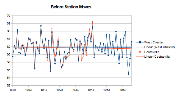
Your being confused by station moves. We've been over the importance of West Chester and Coatesville station moves a zillion times. The moves were large enough to obscure the real climate trend. As shown upthread, without the station moves there is no cooling at West Chester or Coatesville. Here's another way to remove the station moves: plot the before and after move data separately. Without the confusion of the station moves, West Chester and Coatesville are in good agreement on our local weather. Before the station moves, May temperatures were close to 62F at the two stations. After the moves they had cooled to 60F. The trend lines for West Chester and Coatesville both before and after the station moves are almost the same. There is no change in temperature before the station moves; and, warming after the station moves. Further confirmation that West Chester and Coatesville have warmed in May. The effect of the station moves is easily seen by comparing the regression lines around the time of the moves. Immediately before the station moves, May temperatures were close to 62F at the two stations. After the moves they had cooled to 60F. This example shows the value of bias-adjustment. As Coatesville and West Chester demonstrate, the raw data from a single station can be misleading when there are major station changes. This isn't rocket science. Knowing the station histories, it is easy for me to remove the station moves and get a more accurate climate trend that is close to NOAA. You could do the same.


_X.thumb.png.47ca5c2e0afbbf336f75bcc5966fc69d.png)

.thumb.png.de242b992b8e06f5bccb7cefcd4d3596.png)

