

tnweathernut
-
Posts
4,649 -
Joined
-
Last visited
Content Type
Profiles
Blogs
Forums
American Weather
Media Demo
Store
Gallery
Posts posted by tnweathernut
-
-
2 hours ago, Carvers Gap said:
It looks like all global ensembles take some energy into central TN, and have a subsequent energy handoff. I hope this is a case where operationals are leading the way.
Has been a thorn in the side of snow lovers here in east TN numerous times over the years. Any semblance of energy west of the apps would really hurt chances of a winter event for those east of the plateau (except maybe SW VA), outside of a mixed precip to rain type deal with really good timing (i.e. overnight/early am arrival). Would really like to see a consolidated low pass well to the southeast of our area. Without an unusually cold high structure over the top, a piece of energy west of the apps will make a winter event almost impossible to work for those outside of elevation east of the plateau or the CAD favored regions east of the Apps.
We may get this type of setup later in the month if some of the ensembles showing the polar vortex trapping underneath blocking have some truth to them. It’s fun to imagine an active southern branch with very cold air trapped and pressing into a good chunk of the country. This winter already feels much different than last, even if we don’t score a winter storm over the next week.
-
 3
3
-
-
5 minutes ago, Carvers Gap said:
Yes, we live in a place(greater TRI area) where strange stuff happens during snowstorms. I remember when @BlunderStormcouldn't buy a flake of snow one winter due to an odd snow shadow there that was only prevalent that winter due to the angle of approach of many of the storms. I have seen Johnson City crippled by snow, and only had 2-3" IMBY. As I noted above, it seems TRI almost always has the lowest denominator total recorded - very suspicious.
Likely this one. Should probably also put this in banter, but it's not like we are tracking, so I will put it here. If a mod wants to move it, so be it.
Deaths blamed on heavy Appalachian snowfall
http://www.cnn.com/WEATHER/9801/29/winter.storm/traffic.boone.jpg Commuters brave icy roads in Boone, North Carolina January 29, 1998
Web posted at: 12:38 p.m. EDT (1238 GMT)(CNN) -- At least nine deaths were blamed Thursday on a storm that dumped several feet of snow on the central Appalachians starting Tuesday night, clogging highways with ice, snow, and snowbound vehicles.
The storm also took out electrical service for thousands of customers in eastern Tennessee, West Virginia and North Carolina; by early Thursday morning, 258,000 households in those states were still without power.
The storm had largely turned to rain on the coast by Wednesday, stirring up a pounding surf that pulled one empty house and part of another into the Atlantic Ocean near Virginia Beach, Virginia.
The South looks more like the North http://www.cnn.com/images/9706/qt_icon.gif 786K/21 sec. QuickTime movie But it was the heavy snow that caught the region off-guard. "This was worse than the blizzard of February 1993," said Bobbie Freeman, the fire chief of Jonesborough, Tennessee. "This snow was so wet that trees were coming down everywhere."
Buildings collapse under snow's weight
http://www.cnn.com/WEATHER/9801/29/winter.storm/tree.wv.jpg allen tree limbs damage power lines in Beckley, West Virginia Power remained out in parts of the state, with 80,000 to 90,000 people in northeastern Tennessee still coping without electrical service by Thursday morning.
Tennessee's Carter County was hit especially hard by the storm. Up to 4 feet of snow fell on the county's Roan Mountain; flooding in Carter County just 2 1/2 weeks ago killed seven people. About 75 percent of the county had no power, and it could be five days before service is restored, said Sheriff John Henson.
"We need a break -- a flood one week and a blizzard the next," he said. "I don't know what will come next."
The Tennessee National Guard and the Red Cross were providing transportation, manpower and shelters, and the Tennessee Emergency Management Agency has sent personnel to help the local emergency management agencies.
National Guard comes to aid of stranded
In North Carolina, where the National Guard had been rescuing stranded motorists and taking them to emergency shelters, the snow had begun to melt, allowing traffic along the state's Interstate 40 to start moving again by Thursday.
However, melting snow was expected to turn to ice by Thursday night, making travel conditions even trickier.
Meanwhile, 12 eastern and southern West Virginia counties were still under a state of emergency. Beckley, West Virginia, received 32 inches of snow, and wasn't expected to get its roads cleared until Thursday at the earliest.
"There's got to be somebody in West Virginia with a front-end loader and a dump truck," said William Summers, a South Carolina driver bound for Canada. "If this was the highway commissioner's wife and kids, we would have left here yesterday. It's ridiculous."
And the storm's slow sweep over Virginia left behind three dead, two from traffic accidents. A third Virginia man died of an asthma attack while stranded in his rural home.
The storm system dumped 20 inches of snow in parts of the state's southwest mountains, and more than 3 inches of rain east and north of the Blue Ridge Mountains. Tides were up to 4 feet above normal.
-
5
-
-
Just came here for the @Holston_River_Rambler animated euro gif's and the @Carvers Gap control snow map. All kidding aside (kinda), we are 5 days away from a system with potential for something other than rain. It's the first legit chance we've had this year. We seem to have a ticket to the game and have made it to the ball park. The maps at 500 want to roll energy beneath us every 2-3 days. I just hope mother nature throws our strike out prone batter a belt high fastball he can connect on with one of them.
-
6
-
-
40 minutes ago, Carvers Gap said:
Some great model runs for the timeframe before the 10th, and we had better hit.
The new GEFSext MJO plot doesn't even get the MJO out of phase 5 until Jan 28th. It is conceivable that the entire month of January could be spent in warm phases of the MJO - and still not even rotate into 6 which is the warmest. Now, I am not convinced this is what occurs, but that plot is the worst case scenario - and that is the eastern ridge hooking into the NAO scenario likely. That said, notice the MJO is not out of phase 8 yet, and most modeling didn't have the current stall in 8. However, seeing the MJO stall out in 5 would be a surprise to me......but the plot below would basically wipe out out best climatology from Jan 15th to roughly Feb 7th. Again, it is possible this is completely wrong, and I will probably look at that scenario later. Think last year where the MJO wouldn't leave the warm phases....this winter, it should really not want to go there. The CFSv2 seasonal this morning has flipped January to warm. Basically, the CFS is banking on the second half of January being very warm. Most LR modeling is flirting with a western Atlantic ridge which is hooked into the NAO for an undetermined duration after Jan 10th. That is a huge problem. Let's hope that is in error.
That connection has been more common than a disconnected AR/NAO the last decade. Definitely going to have to be watched. Except from mid March through April. Then the -NAO tends to be solid with the ability to swamp us with 38-42 degree rainstorms. lol
-
2
-
-
Very probable a marginal airmass to work with around the timeframe we are discussing, and we'd likely have to thread the needle................ but when do we not? We have very few clean opportunities for snow in the midsouth. Just get a system tracking to our south in January, put someone on the northwest side and see what happens. Admittedly, it's an outside shot, but it's not a zero opportunity, IMO.
-
7
-
-
18 minutes ago, Carvers Gap said:
Give me some of that.
That's the same period I have been watching for a few days now for the one I thought had good potential. Just hope as it comes into better view it's a legit shot at something we can track. I'm disappointed in the late week. From a couple of days ago I thought the energy coming off the lakes and rotating through would enhance snow showers for the mountains and give a decent shot at a light accumulation for the lower elevations from middle TN through the plateau and into northeast TN.
-
3
-
-
29 minutes ago, Carvers Gap said:
Stellar look on the 12z Euro at 168.
No fair, you are ahead of me. lol
Good to see a duck or two on the pond after catching up to you.
-
1 hour ago, Carvers Gap said:
Other than that, feel free to debate, discuss, and dissect the above. Those are just ideas and some brainstorming from this morning. Have at it!
Just looking at your ensemble maps at a glance. The euro and the canadian ensembles look like a recipe for overrunning somewhere down the road......... Appreciate all the work you put into your thoughts. I enjoy reading them. Wish I had more time to dig into things and contribute, but with work I seem to always be pulled in a thousand different directions!
-
3
-
 1
1
-
-
The system that follows around day 9-10 missing the TN Valley to the south interests me….
-
6
-
-
Had a light dusting in Gray this AM (in the mulch and along the edges of the driveway. Had a couple of decent bursts last night, but not much. On my drive to the office this morning (Johnson City to Erwin), we didn't have any snow on the ground, even through Unicoi. Looks like most of the heavier bursts stayed north near the TN/VA line and up into SW VA, also above 3500 feet and along the ridgetops.
-
4
-
-
Interesting to note the big system that just missed to our east was projected to be a southern apps mauler (albeit mostly rain). I thought this might make the system we have now further north and east. I don't really bring this up for that reason though. Just something to watch as the winter progresses.
-
4
-
-
The Hendersonville to Gallatin tornado went less than 1.5 miles from my family home where my dad still resides. I was busy sending texts to all my friends/family in group chats trying to keep them informed in real time. The signature on radar was evident well west of Nashville. For the time of year, I was surprised it held together as well as it did as it slid by just north of Nashville. Prayers for all those affected and especially those grieving the loss of a loved one today.
-
2
-
-
5 minutes ago, Holston_River_Rambler said:
I have a friend who is at the foot of Grandfather Mt right now at around 4000 feet and she says all rain there.
Honestly, that cell fell apart like a wet taco as it hit the mountains.
-
9 hours ago, Holston_River_Rambler said:
Unfortunately, probably looking at a Thunder in the Mountains Watch later this week.
Good call, but you probably didn't know later this week would be today. haha........
-
2
-
 2
2
-
-
6 minutes ago, Holston_River_Rambler said:
If y’all have a minute and are near a computer check out the Beech Mt resort cam. You can see the storm rolling in from the valley. I’m definitely going to try to watch it since temps are still in the upper 30s up there.
Snow boarders about to go from this is fun to not so fun if this comes in as a wind driven rain................
-
2
-
2
-
-
If the squall today is any indication of the energy to come through northeast TN and the mountains Tuesday overnight into Wednesday morning, could be a surprise or two........ I didn't expect to have thunder, lightning, and 40-50 dBZ's.
-
4
-
-
On 8/9/2023 at 4:35 PM, Holston_River_Rambler said:
Thanks man, I'm ok. Been a rough year for the Rambler household. I lost my dad and my wife lost her mom within one month earlier in the year. Been dealing with a broken toe and possible meniscus tear for the past couple of months too. I'm doing ok though. Saw some snow on the GFS in British Columbia and was already thinking about one of those zoom in gifs, lol.
Worst of the storms passed us by this week! I have some good summer pics I will post soon. Hope all is well with y'all !
Just seeing this from back in the summer. I don't get in here much during the summer season (unless there's a severe threat). So sorry to hear about your losses. I hope your toe and knee are doing better!
-
2
-
-
18 hours ago, PowellVolz said:
We could use your prayers… my wife was diagnosed with breast cancer this week. Do not have all the info just yet but as of now the outlook is positive. Feel terrible for her. She just completely recovered from the brain tumor she had removed 2 years ago. God has been there and he’s not leaving us. Keep us in your prayers. Thanks guys!!!!
.Praying for your wife and for you as well. Back in the summer, my brother in laws fiancé was diagnosed with triple negative breast cancer at age 37 and her markers were such she wasn't a candidate for any of the immunotherapies. Before beginning chemo, they found out about a new clinical trial at Vanderbilt. She was the first or second person in the country to be in it. Her results were fantastic and the tumor was largely eradicated. She has since had double mastectomy surgery and is on her way to recovery. I pray your wife has similarly excellent results. Let us know if we can do anything for you guys....................
-
4
-
-
2 minutes ago, matt9697 said:
That will no doubt be on social media soon. Make a good screen saver.
I don't even know where to find the control run, but the OP was interesting in giving the mountains over 24 hours of snow showers and a stalled low in the MA.
-
1
-
-
1 hour ago, Carvers Gap said:
The Euro is a nice pass on the 12z run. Eastern valley gets just enough of a warm nose. But if we can't have it, am I wrong to hope that it rains in the MA as well since they have complained all winter to the n-th degree?
Tough to see the second system in the last month or so with a perfect pass being shown and no snow in the northwest quadrant. Really bad timing to have zero cold highs coming down during this time period. Even a mediocre cold high would get it done. Those cold highs don't start showing until we get to the latter end of the 10 day period.
-
2
-
-
Welcome to Tennessee, where spring comes before winter……….
-
2
-
3
-
-
16 minutes ago, Carvers Gap said:
Regular crap fest. Cosgrove notes that his analogs for spring are actually warm - so there is that. Maybe we catch a bit of residual Nina to keep things seasonal. The Euro Weeklies were just about as ugly as one could get. I said this earlier...I don't think TRI's last snow has been had yet. I could be wrong. It takes well BN temps in March to score, but that possibility is there early in the month, and maybe even later than that. I think we continue to see the MJO loop through cold phases -> warm phases -> and then cold phases...wash, rinse repeat. The signal for March is a bit more conflicting that it would seem on the surface. April looks nasty as does the early part May. Hoping this doesn't got to a super Nino next winter. The QBO in conjunction w/ a weak-ish Nino would be really good following a La Nina triplet of winters.
When was the first? I kid, I kid....................... lol
-
1
-
2
-
-
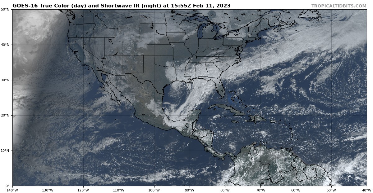
For east TN - Just noting we are in early ish February, with a near perfect track of a surface low, and a great 850 low pass incoming (including a deform band setting up somewhere in east TN) and we are leaning rain, even inside the deform. This satellite picture, knowing the date, should make your mouth water if you like snow. Just goes to show how poorly we do snow in the south. I'm still hopeful some in our region find flakes, but my hopes for a widespread snow event tapered about 36 hours ago.

-
2
-
 5
5
-
-
If this turns out to be predominantly rain, the RGEM will have been the most consistent. The euro will turn out to be the biggest failure. JMO
-
3
-
January Medium-Long Range Discussion
in Tennessee Valley
Posted
I was thinking the same thing.