

tnweathernut
-
Posts
4,649 -
Joined
-
Last visited
Content Type
Profiles
Blogs
Forums
American Weather
Media Demo
Store
Gallery
Posts posted by tnweathernut
-
-
5 minutes ago, Carvers Gap said:
And man, it just stalls off the coast. Whew!
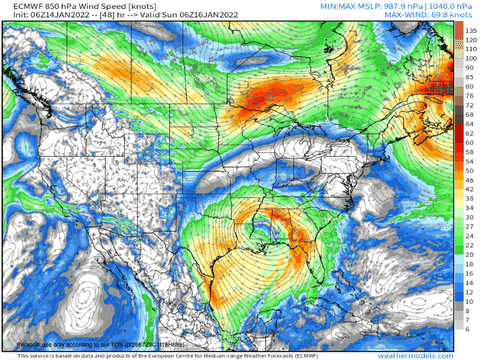
This is why I don't trust the dry looks on modeling. The MJO does not support a completely suppressed pattern. No idea if that is right or even close to it...but that is a really big storm. No way modeling has that nailed down at 200 hours. Could be gone on the next run. That said, modeling is from time-to-time seeing coastal genesis of big lows. Sure, we could get caught between the northern stream sliding stuff to our north and the STJ sliding stuff below us. BUT, if those two every sync...that run is an example of what could happen.
Sot, that is two storms next week to watch. One is mid-week and has a marginal temp profile. It actually looks good on WxBell's stuff. Then, there is the weekend storm potential after that.
Lows around the lakes are no bueno and the best way to wreck marginal thermals. I feel like it's only showing snow because of the time of arrival in the early AM hours. That said, it's nice to see blue on the map.
And the follow up bomb is pretty. We might have to go find people in eastern NC if that happened. lol
-
 1
1
-
 1
1
-
-
3 minutes ago, Carvers Gap said:
During the last three storms, it seems like the western envelope of modeling at this range has generally been correct IMHO. Anyone see that differently? Seems like all 3 storms had sharp northwest trends for 2 days worth of model runs, then jogged back the opposite direction by maybe ~10-20% of that mileage. But for now, we need to get that storm on all three globals. It is on 2/3.
At least for east TN, this one has quite a bit more potential than the last. Cold air already in place. Overrunning to Miller A vs Miller B into a marginal airmass, etc…..
-
4
-
 1
1
-
-
Just now, Icy Hot said:
Wonder why MRX is down playing this?
Notoriously conservative……. 5+ days away.
-
2
-
-
2 minutes ago, Weathertree2 said:
I feel for you; I can say I have allot less experience than most on here but it just seems like this one vs the last one has a higher bust potential.
Anytime there is a handoff, primary to secondary and a funky 850 evolution, you can almost bank on busts (both good and bad), IMO.
-
2
-
-
17 minutes ago, Holston_River_Rambler said:
I don't know if what I'm about to say is how this works, but it looks like there is a weakness in the windfields that the 850 low is getting pulled toward:

that seems to be what is encouraging it to pull north.
I thought it looked that way also. I mentioned the interaction with the energy diving in behind yesterday and thought it was the problem in pulling the 850, or a piece of it, further north into the valley. It really hurts not having a strong anchored high sprawled from northern Missouri to the Mid Atlantic.
-
1
-
 1
1
-
-
2 minutes ago, TellicoWx said:
18z EPS

I don’t think I have ever seen a Euro ensemble run under day 4 with more than 4” across the entire state.
-
2
-
-
10 minutes ago, Holston_River_Rambler said:
RGEM looked better with the vort and 850 low:
I can't say I have ever seen a tightly wrapped 850 in east central Alabama suddenly go all kidney bean look and barf all over east TN, but I think the energy behind it is interacting with it and causing it to pull more north.
-
4
-
-
18 minutes ago, nrgjeff said:
NCEP is markedly more bullish than even this morning. Those ensemble individual lows tell the story better than the mean. South!
All optimism excludes Chattanooga by default until within 12 hours after the snow is on the ground.
fixed it for you.
-
4
-
-
Just now, TellicoWx said:
If you want sanity...turn on the 850 wind field maps and follow the swirl...dont need any other map on model runs...north/northwest of the swirl...golden. over the top of you/east/south...move on to the next run
Good post. I do this often and IMO it's probably the most important feature to key on if you want to find where snow is likely.
-
2
-
-
1 minute ago, Wurbus said:
UKMet snow totals below. No love for middle/west TN
UK has been remarkably consistent showing a strong cutoff. No clue if it's onto something or just on something.
-
2
-
-
Can anyone name a storm that dropped a foot on Chattanooga that went ice from Knoxville to Johnson City? I’m not sure one exists…….
-
3
-
1
-
-
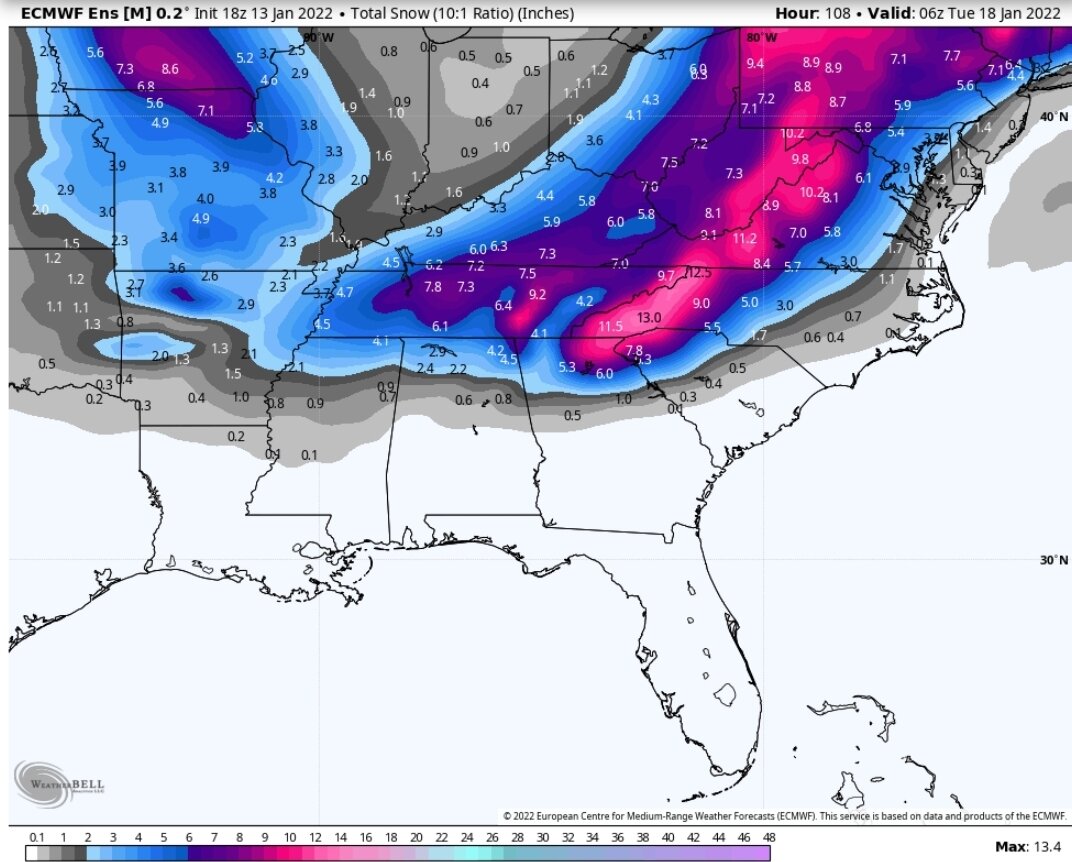
1 minute ago, McMinnWx said:
13.4 inches for Chattanooga?!
Jeff says toss in 3, 2, 1……….
-
1
-
5
-
-
18 minutes ago, Vol4Life said:
Do you know what the official measurement from BNA was for the last storm?
I should change my post, appears they officially recorded 6.3" of snow. I don't remember the last time there were 2 six inch snows in one winter either. Can't find an official measurement for January 3rd, but they received between 1 and 2.9" across the city that day. Quite the winter run for our friends in the mid state!
-
I am not sure I remember a year when Nashville recorded two 7+" snows. If it happened, was probably back in the 1800s. Chattanooga snow hole checks out, as do the downslope areas coming up the valley. Now if it were only 24 hours away.
-
2 minutes ago, nrgjeff said:
Honestly the GFS is better than the Euro at sniffing out a warm nose disaster.
That said I'll take some more Ukie. Hey the British Pound is stronger than the US Dollar or Euro right now. Currencies method?
In all seriousness, I'm preparing for cold rain KCHA. Might as well go 0-3 and the strike-out.
Maybe your second batter will do better, but knowing the plight of Chattanooga..... I won't hold my breath.
-
2
-
1
-
-
5 minutes ago, Vol4Life said:
From Southeast Forum...Ukie
Used to be when the Euro and UK were in lockstep with each other 3-4 days out you could go ahead and dust off your snow shovel.
-
1
-
1
-
-
It's obvious there are two camps this am, but the ensembles tells me there's a great degree of uncertainty between those two camps at this point. As long as you set your expectation level low, it's pretty easy to take the swings (or in this case, Sherman's march to the northwest). Just a hunch, but I think the trend stops at 12z and moves back toward something weaker as shown on the 6z Euro.
-
4
-
-
My two cents…. I lean toward the general solution the Euro has, and not just because it shows more winter potential for the weekend. I say that because beyond day 5ish, the GFS is (a lot of the time) too much northern stream (progressive) and not enough southern stream, squashing chances. The Euro (at least in days of old, lol) would handle this setup much better. Interested to see where this week takes us.
-
3
-
1
-
-
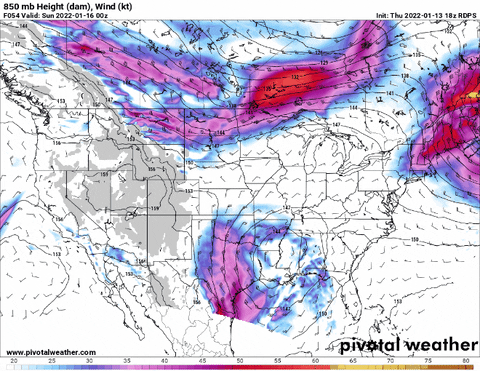
1 hour ago, Holston_River_Rambler said:
To follow up on what John said, the 0z GFS was what I call the space invaders pattern. The northern stream and the STJ keep shooting energy at each other like the old video game:
Only a matter of time before the two streams connect and we have another legit trackable snow/ice system, IMO
-
5
-
-
22 minutes ago, Vol4Life said:
No joke! That low sitting on the FL panhandle is intriguing! I haven’t paid much attention to the CMC this winter. How has it been fairing?
It wasn't just that, but at 500 you could see the two streams beginning to phase. Fantasy land, but not an unreasonable solution given where modeling takes us in the LR.
Also, the Jan 15th period looked a bit closer than I remember it on the GFS and CMC yesterday.-
5
-
-
13 minutes ago, John1122 said:
MRX did explain what they think happened. The storm sped up and outran the forcing. That's why Middle Tennessee got dumped on for 12+ hours and eastern areas mostly faltered.
I am sure that's happened before but I've never seen it explained before. It's not a common thing it would seem. You don't often see Nashville cash in big but Tri not be able to get there in what appeared to be the set up. Usually that only happens when there's a SE ridge like last year and it's snowing in the mud state and 50+ in the far east.
I guess we can put that in the bin of things that can screw up a snow event…. It’s a BIG bin.
-
3
-
1
-
 1
1
-
-
1 minute ago, John1122 said:
It's nice. The nw snow is smaller flakes and it's peppering down out there now. Looks like I might squeeze out 5 inches. It's a shame that the valley got warm nosed. Looks like some areas around 40 and north have a shot for some more backside showers. I assume our mid state guys had a good day.
I have numerous friends from Nashville to Gallatin, Hendersonville, and Westmoreland. A lot of them scored a 6-8" event and a couple have indicated they received almost 9"... It's been a LONG time since this widespread a snowstorm occurred for the midstate. Happy for them.
-
3
-
-
3 minutes ago, nrgjeff said:
MRX just updated. Knox may start as rain. Quick change to snow.
AFD does not show it yet, but they just wrote it to EMs.
Thanks, Jeff. Were there any changes noted for KTRI?
-
6 minutes ago, John1122 said:
What??
"However, 12Z models have shown a substantial increase in qpf. This could translate to snow amounts pushing over 4 to maybe 6 inches for areas along and north of I-40 and this would require a Winter Storm Warning. Our reason for keeping the advisory in place is the sudden jump in model qpf."
Models have been showing 4-6 inches in northern Middle and the plateau for days on end. Not sure where this "sudden jump" talk came from.
Agree, this is crazy talk.
-
5
-
Winter 2021/2022 January Thread
in Tennessee Valley
Posted
Canadian vaporizes a nice piece of energy in the southern branch. From closed to pretty much gone in less than 24 hours. Will need to watch this one if we have a closed piece of energy at 500 in central Texas.