

tnweathernut
-
Posts
4,927 -
Joined
-
Last visited
Content Type
Profiles
Blogs
Forums
American Weather
Media Demo
Store
Gallery
Posts posted by tnweathernut
-
-
On 2/3/2026 at 11:44 AM, GBOVolz said:
Not in our area but thought I’d share these pictures from a fire at Elm Hill…Percy Priest lake in Nashville. Mt Juliette area.


.There are a lot of boat owners, a marina, and an insurance agent having a very bad day……
-
 1
1
-
-
12 hours ago, John1122 said:
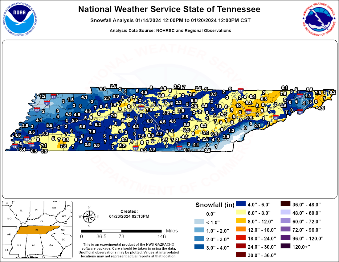
Some social media response to that terrible map. This is why snowfall averages are off and it effects weather model performance.
With spotters and accumulations being posted from a lot of different places, it makes you wonder how snow maps in the year 2026 are off that much. Sure, I get the guy who measures a drift to inflate, but that goes both ways. It's just as much an error when you post "official" measurements off by a factor of 2x or 3x also.
-
3
-
 1
1
-
-
Just popping in from the valley down here to say congrats to all you mountain folk on reeling in a memorable snow!
-
4
-
-
Occasionally getting into heavy snow. Not really even showing up on radar. Nuts!!
-
7
-
-
1 minute ago, nrgjeff said:
We are officially past doubling down in blackjack. We have achieved a Hard Way in craps. Pays more.
Two inches East Brainerd. Light snow continues.
LOVE playing with house money! Get it, Jeff!!
-
2
-
 1
1
-
-
1 hour ago, fountainguy97 said:
Really starting to stack up now. Probably 7" or more. Temp is 14.7. Probably another 4-6 easily on the way.
It’s the one we’ve been waiting years for. The south and east of I-81 crowd can finally claim victory! Enjoy!!
-
2
-
-
Winter wonderland here in north Johnson City. Guessing around 6” so far, moderate snow continues. Expecting another 2-3” -
-
2
-
-
Got to my home in north JC. Snowed moderately to heavy all the way from South JC to the Boones Creek exit. Some snow in the median and shoulders on the bridges.
Have between a half inch and inch and snowing light to moderately at times.
-
1
-
-
It's not often these days you see a snowfall prediction map where south and east of I-81 is the expected max zone....
-
1
-
-
2 minutes ago, Carvers Gap said:
My point and click was dropped(max) from 7 to 3. I think the fact none of this is sticking in the valleys has them rightfully spooked. The sun is eating into totals big time IMBY.
It's a fair concern, but I think you were only supposed to be around a half inch by 4:00 pm and an inch at 6:00 pm. I viewed this as anything falling before dark as bonus flakes.
-
1
-
-
Tracking a snow system is always a rush, but I'll say the quiet part out loud................. it sucks looking at temps, comparing short range models to reality, and waiting for first flakes and accumulations.
-
Low to pushing mid 40's along Main Avenue in Erwin. I think temps collapse nicely this evening, but I wasn't expecting to see 40 at all. Thought the cloud deck would move over and hold us to the mid 30s
-
2
-
-
Just now, Carvers Gap said:
The 12z GFS is just one system after another, beginning on Weds.
Good bye La Nina.
-
1
-
2
-
-
13 minutes ago, Math/Met said:
It has been like that for awhile. We do okay with the 3-6 inch snows, but have somehow missed all of the bigger ones. It's been a LONG time since I've seen a double digit snowfall. The 90s were great for big snows, but this particular area has struggled since then.
Considering how snowless (relatively speaking) the 90s were, it makes it even more of a head scratcher, IMO.
-
1
-
-
Just now, John1122 said:
Weather Next/Google AI at 12z was nearly a carbon copy of 06z.
It has been rock steady. Kind of spooky to see something that consistent.
-
4
-
-
-
3 minutes ago, GBOVolz said:
Didn’t you get at least 7 in Jan 24’?
.I had about an inch and got downsloped. Guessing he did also.
-
1
-
-
1 minute ago, fountainguy97 said:
I've lived here since June 2019. The largest snow I've seen in that time is 7" from an over performing NW event in February of 2022. I may finally break that 7" record this weekend.
From one downsloper to another............ don't jinx it. lol
Kidding aside, this is a great setup for those south and east of I-81 for once and that doesn't diminish the chances north and west of 81 either.
-
3
-
-
Let's ride east Tennesseans. I'm hopeful the system can throw moisture back a bit more west (ala the Euro) to get as many from our forum as possible in the boat.
-
4
-
-
8 minutes ago, BlunderStorm said:
Partial 12z model suite. Waiting on the Euro.

It's going to be hard saying we've been RRFS'd. I always preferred getting NAM'd.
-
4
-
1
-
1
-
-
4 minutes ago, TellicoWx said:
If your south of 40 or west of 75..you're gonna need to send them a visual confirmation first lol...I have no doubt the social media backlash from the ice storm has made them lean heavily into their conservative side.
I could almost see a discussion from management letting them know................."this is why we don't do anything other than conservative around here". lol
-
1
-
-
The truth is probably somewhere in the middle of these QPF amounts on the euro. One thing I mentioned to Carvers yesterday…….. how many times out of 10 things trend (and verify) east and south of modeling inside of 72 hours. My guess would be 1. Doesn’t mean Knoxville area cant work its way out of a snow, but it’s not like it’s a bad thing being on the north and west edge of guidance 36-48 hours out.
-
1
-
-
8 minutes ago, *Flash* said:
Middle TN needs a prayer. No kidding!

You are definitely right! Prayers in more ways than one ….I had hoped they’d have been able to make more progress before the next blast of cold air came rushing in.
-
The 18z NBM increased totals from Knoxville and points east and has been beefing up the last several runs, FWIW
-
1
-
February 2026
in Tennessee Valley
Posted
I noticed it's had a convective look on modeling for days now.