

tnweathernut
-
Posts
4,649 -
Joined
-
Last visited
Content Type
Profiles
Blogs
Forums
American Weather
Media Demo
Store
Gallery
Posts posted by tnweathernut
-
-
Just now, PowellVolz said:
I still believe when dynamics take over this will change to snow and will stay snow for anyone on the NW side. If the temps were right, we would be looking at 8-12” across the valley IMO.
.The biggest thing I don't like for anyone in east TN is the deform band sets up across the plateau and even into middle Tennessee. This isn't the way to get a big snow anywhere near the valley in east TN in light of a very marginal temperature profile. JMO
-
 5
5
-
-
3 minutes ago, fountainguy97 said:
RGEM is king.
And the solution is poo for snow lovers. lol
-
3
-
 1
1
-
-
27 minutes ago, nrgjeff said:
MRX probability chart is reasonable for an event 60 hours out with borderline temps. Keep in mind probability considers all parameters, climo and time to event. Probability 3 days out is usually bearish compared to deterministic numerical models.
MRX rightfully blanks Chattanooga, and does include the Cumberland Plateau. Maybe I'm biased in favor because it has things in common with my longer post bottom of page 20 this topic.
PS. I'll post in the event topic on Friday. If I post too early, I'll surely jinx it.
Eh, it would be ok........... Here in Tennessee if a donkey farts into the wind and it can throw things off when it comes to snow. As always, appreciate your input.
-
1
-
 3
3
-
-
I'll give Morristown this......................... 9 times out of 10 they will be right about snowfall in our region when playing it down. We (snow lovers) just have to hope this is a 1 of 10 situation.
-
3
-
-
3 minutes ago, fountainguy97 said:
It's strange but in a way trending toward others. another tick or two west and it'll start bringing it north pretty quickly. That being said the 18z GEFS is a complete miss for our area too. It sure is stubborn. Still by far the outlier.
Either the outlier or the leader........... I don't want to think about the latter. lol
-
4
-
-
1 minute ago, Carvers Gap said:
The 18z GEFS is east of 12z. Swing and a miss yet again by that model.
Continues to trend deeper, further southwest, and more closed off at 500. A little slower and not as progressive and it would have looked very similar to the snowy southern app solutions, IMO.
-
3
-
-
Honestly, the presentation at 500 on numerous modeling has all the earmarks of a southern apps tree snapper.
-
5
-
-
It's always hard to extrapolate, but at 500 it's a touch deeper and sharper at 30. Would be surprised if it doesn't come in further west than 6z. Flow is definitely backing by 36. This one should be further west than 6z.
-
1
-
-
1 minute ago, Carvers Gap said:
Thinking more about that good question...I say let it rip in terms of strength. We are going to need that to overcome temps. We want cold air crashing into the NW quadrant. I think we only get that if it deepens.
Not saying this one will happen, but our best snowstorms have occurred during the day when temps from 48-72 hours out were projected to be in the low 40's and what ended up happening was 33 and heavy snow. Also in very similar scenarios to this I have witnessed downsloping be a non-factor even though the flow on radar is directly over the mountains from SE to NW. Just a FWIW as we try and figure out if this potential system has legs.
-
4
-
-
22 minutes ago, fountainguy97 said:
The valley is nuked.
 o
o
I think everyone is out enjoying the 60+ degree weather. Lol 18 Z was definitely some serious eye candy for east TN and the southern apps.
-
4
-
 1
1
-
-
2 hours ago, Carvers Gap said:
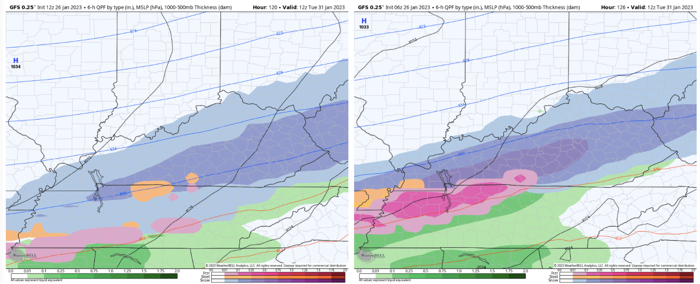
This was a textbook over-running event in west TN. When we see cold charge into TX w/ a slight eastward push...it often doesn't make it past the Plateau or even to the Plateau at all. Wave after wave of frozen precip rolled through that area. Modeling did a great job with this event, especially the CMC and RGEM. The Euro was very late in recognizing where the cold air boundary was. Also, the GFS(which was thrown out by some services) was very close to being right w/ its cold air boundary. The GFS has been decent inside of 5 days.
Yes, but quicker to realize the sagging south of the final wave of precip where other modeling had it into east TN..... so I guess not great, but good on the back end.
-
2
-
-
5 minutes ago, Carvers Gap said:
Different time frames by just a few hours as both models(12z GFS and Euro) accentuate different waves. 12z is on the left and 0z is on the right.
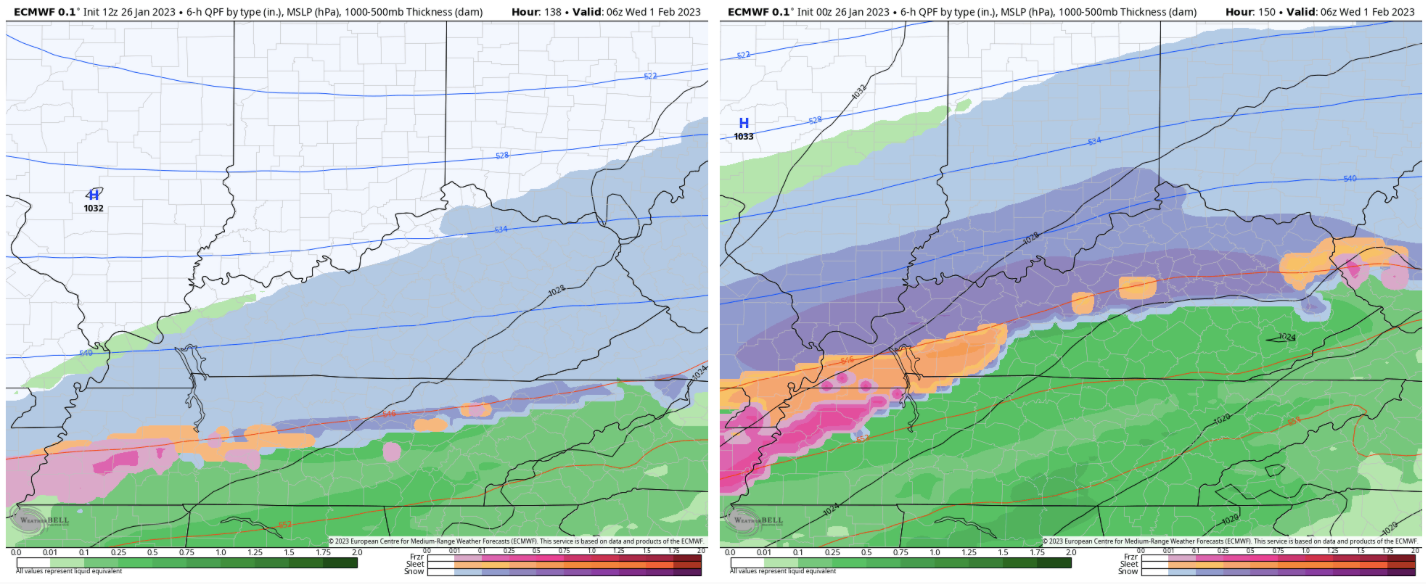
This one is the low hanging fruit, IMO. Close in, on multiple models, and has that "slider" look. Weak wave FTW........................ for someone.................. hopefully.
-
1
-
-
If not for a last second (gimmie) layup allowed by TN reserves at the end of the Georgia game.................. TN would have held GA to 39 points in a game of D1 college basketball. Man this D is good when they lock in.
-
2
-
-
1 minute ago, Carvers Gap said:
For kicks and giggles....this is where it heads to about 100 hours after the map above. It is colder here prior to this snapshot. I just wanted to show this as North America is just frigid in this run. Impressive for a model which has been known for a slight warm bias in this range.
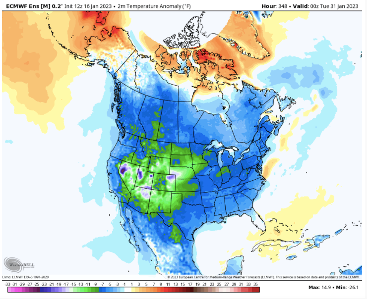
TBF - if we get an airmass like that and a 500 profile as indicated on the ensembles................. at some point there'd be a nasty snow/ice overrunning event from TX/OK through the TN/KY region.
-
1
-
-
2 minutes ago, Carvers Gap said:
The 12z EPS is really a great run. This is my favorite.
Just have to keep systems coming across and at some point over a 7-10 day period........... something would likely be a hit.
-
2
-
-
Just now, Carvers Gap said:
It might be a tic northwest on second look, but was basically the same run. Of interest, it does have a mean slp over New Orleans on the 22nd. Get a low placement there, and someone in the forum area is getting frozen precip.
Agree, I'd take my chances on wintery for someone in the mid-south with a surface low over NO.
-
1
-
-
4 minutes ago, Carvers Gap said:
FWIW, the ensemble mean on the 12z EPS is not a cutter. In fact, it is so suppressed, it would rob most of the valley of any moisture at all. Good spot.
Interesting. It has been rather insistent on suppression, but EVERY op run cuts. lol
-
1
-
-
As shown by the GEPS and GEFS, it's moving toward a gradient pattern. We would almost have to have a leader follower type setup where the first system drags colder air into the region for the second system to snow on us. The only negatives are we are south of the Ohio River so gradient patterns more often than not leave us on the wrong side of the tracks. Still, just takes one to make a memorable winter and we at least seem to be moving toward "opportunity"............. Any way you slice it, there should be plenty of moisture the next 2-3 weeks.
-
3
-
-
I'll add............... with that much cold potentially coming south it won't take much to see what is shown as a cutter with all rain now morph into a system that is more frozen (espcially on the front end). Cold air is pretty dense so if we can get it on the move, it may press much further south into coming disturbances than currently shown. I'm just interested in the pattern on a large scale currently. If we head where this is showing the lead time on a wintry system may not be much longer than 3-4 days.
-
3
-
-
17 minutes ago, Carvers Gap said:
Medium and LR ensembles for the GEFS and GEPS looks outstanding. If we don't score w/ the first storm Sun/Mon, the one after is also a legit threat. The EPS is cutting through middle TN. That should set the boundary for the second storm. We will know in a few.
Lots of chaos in the flow. I think the "general" look of a cutter or two pressing the boundary further south and east is more probable than not. As long as we have systems remaining in the flow, you'd think we'd (someone in the mid-south) luck up and hit something at some point the next 10-14 days.
-
2
-
-
10 minutes ago, Carvers Gap said:
Yeah, we have been dealing with cruddy source regions for two weeks(still managed and upslope event even though). One consistent variable among modeling is quite severe cold. If that cold chills Canada, modeling nailed that aspect from about 4 weeks. A deepening storm over the East could potentially send a lot of that eastward until the SER fights back. It could just park in the west and not move(GFS operation), but the MJO would argue that it comes eastward(maybe all of it per CMC). For me, I have been kind of conditioned during the past couple of winters to think the cold dumps west and won't move eastward or stalls on the Plateau. So, that could happen. But some of the historical winter patterns have the Rockies to the Apps cold. It has been a long time since that occurred, but having most of the Lower 48 cold is not without precedent. That said, the SER is definitely Nina climatology, so I think it shows. We just don't want a standing ridge as Jax aptly notes.
We always have to walk a tightrope in the mid south……. We actually need some SE ridge. Will be fascinating to watch the next couple of weeks play out. Not worried about February yet, just looking for the next possible track. As you mentioned, we found an upslope event to track in the middle of a terrible pattern so it can happen……
-
1
-
-
With this much cold showing it won’t bother me to see a cutter. Even something that cuts west of the apps can be beneficial for our snow loving members in west (and maybe middle) TN. Wouldn’t be a bad thing to see something cut, drag the boundary deep into the SE and then the next wave have more cold to work with. All in all I’m encouraged for the last week of January.
-
2
-
-
3 minutes ago, Carvers Gap said:
I think the strength/depth/intensity of the cold air behind it will also matter...especially for the ensuing storms which follow. The CFSv2 is now showing 20-25F degree BN departures for the first week of Feb. Cold dumps into the Plains and spreads westward. Interesting to see where this goes for sure.
I don’t want 20-25 BN departures….. let it go westward. I’m still getting pipe claims from the last arctic outbreak.
-
2
-
-
8 minutes ago, Carvers Gap said:
This is the 12z EPS for the Jan 22/23 system. That is about where we want it. Some cutters, but majority take the low road.
Looks pretty simple………Stronger low, warmer and west. Weaker low doesn’t necessarily mean less precipitation and would almost certainly mean a chance at a thermal profile more conducive to a winter event somewhere across a larger section of the mid-south.
-
1
-
February 11-13 ULL event
in Tennessee Valley
Posted
Exactly. This is a big problem for our area. Initially we thought there would be an inverted trough across the southern apps. I don’t know where that thought has gone?