

tnweathernut
-
Posts
4,649 -
Joined
-
Last visited
Content Type
Profiles
Blogs
Forums
American Weather
Media Demo
Store
Gallery
Posts posted by tnweathernut
-
-
1 minute ago, Carvers Gap said:
That is crazy, man!
The insurance guy over here can't catch a break. Several hail storms the past 3 years, last years Christmas pipe buster. Now we get damaging winds across the area tomorrow, likely another round late week, followed by another pipe buster next week. I really need a break.
And people wonder why their home and auto insurances are going up at the rate of double digits increases each year.
-
 5
5
-
-
4 minutes ago, Carvers Gap said:
I grew up a Boston Red Sox fan and a TN fan(mid-late 1970s)......getting hosed is just part of life's right of passage for me. That is probably why I like the weather, it is just some kind of sick hobby that reminds me of my sports hobby. I also like to fish. Maybe I just like randomly being disappointed on a regular basis.
Try being a Minnesota Vikings fan....... lol
-
 3
3
-
-
1 minute ago, PowellVolz said:
I’m afraid that after tomorrow’s system completely clears the country, there could be a big swing for the Tuesday event for a day or so. We just need for whatever happens, happens after the front goes through. What the Euro showed earlier would break our spirits.
.It's no wonder we have so few statewide events. Here in the Tri-Cities, I can get to Canada quicker than I can Memphis. Just so hard to align a storm west to east over that type of distance. Someone usually gets hosed.
-
 4
4
-
-
2 minutes ago, Carvers Gap said:
Good comparison. The good thing(or bad thing) is that likely will change at this range.
Feedback over the Southwest in the operational and more blocking on the ensemble (slight orange above MI)???? The feedback in the operational pops the SER? The SER maybe(?) shouldn't be there w/ that NAO configuration? The ensemble is much colder and has a deeper air mass(cold).
Biggest things I noticed were:
1. The OP has the ridge off the west coast tipping to the northeast. This invites the northern stream to roll downhill further southwest, interacting with the southern branch feature and pumping the heights in the east just enough to screw up something possibly great.
2. The ensemble is smoothed (I get that), but if it has any energy in the southern branch it is suppressed. Since the ridge off the west coast doesn't tip northeast, the cold shot progresses to the SE.
-
2
-
-
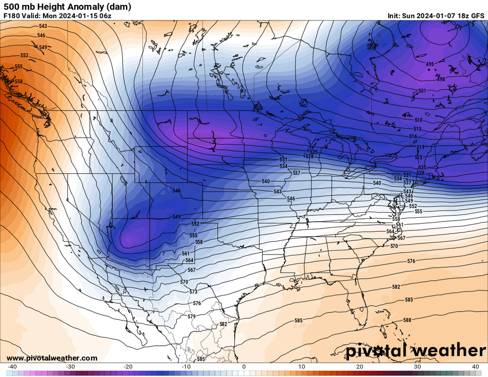
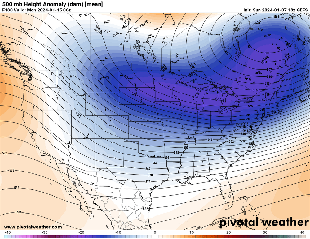
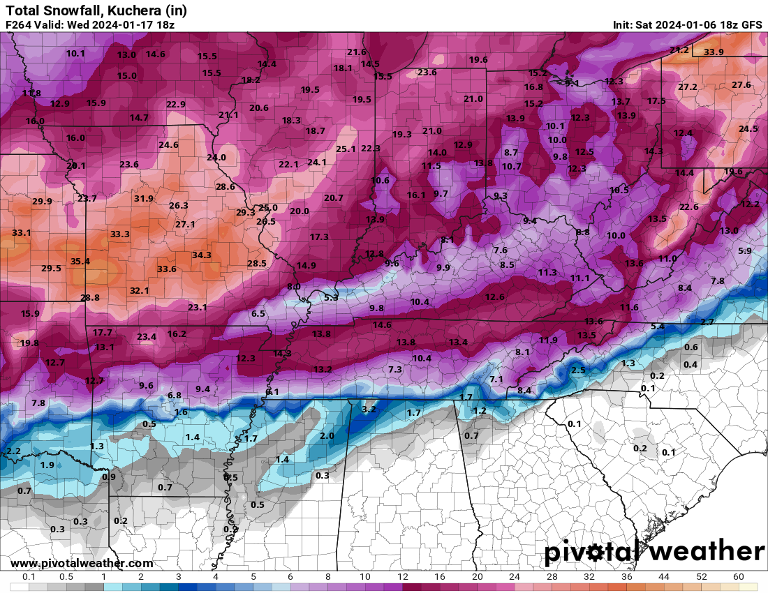
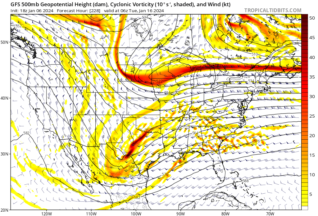
Just looking at the operational 18z vs the ensemble at 500 at hour 180 (truncation). See if you can spot the differences.
-
2
-
-
3 minutes ago, Silas Lang said:
Runs not over, but it looks like the Euro is caving towards the GFS as well. Good trends overall today if you want snow.
Euro will cut. Northern and southern stream started interacting with each other way out west…. Maybe it’s a step in the right direction, time will tell. There are differences even at hour 120 evident, so will likely work out the correct (west vs east) sooner than later.
-
3
-
-
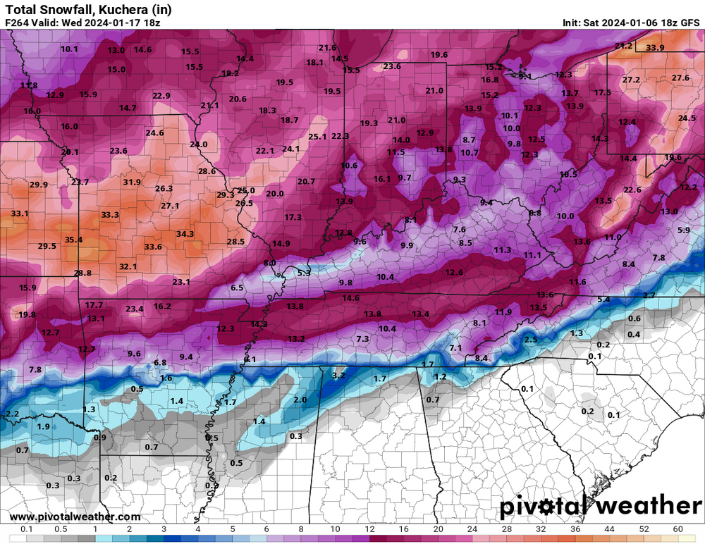
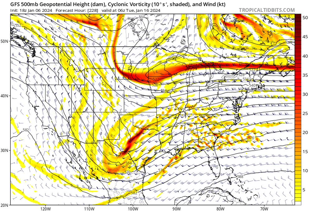
I mean, I think we would all be willing to be patient if this type of event unfolded. I knew it was going to be a banger run when I was following 500 and saw this map......
-
4
-
 2
2
-
-
Looks like a phaser or phaser potential............ Nice to see it as a possibility, even if still in the land of make believe.
-
Major winter storm incoming on HH GFS. Under day 10. This is progress. lol
-
4
-
1
-
-
96 was the last time i remember snow on snow and significant snow on the ground for 2 straight weeks, with snow mounds all over the parking lots around the city. If I remember correct, we got it going by having a heavy rain change to heavy snow. I remember everyone in college talking about how the weather guys missed another one when the heavy rain was falling.. lol
-
2
-
-
Banter, but.................another pipe busting cold snap with no snow would kill my soul. Just want to put that out there. I'm sure I'm not alone. lol
-
7
-
-
12 minutes ago, Holston_River_Rambler said:
Euro was pretty close to a storm on the 12th.
The progression of the 12z Euro makes more sense than other modeling, IMO. First system is passing this weekend, second system (much stronger) early next week winds up and cuts into the lakes. This should move the boundary further east while the next system dives into the southern plains and takes a track a bit further to the south and east. Because of this, I think the system later next week (day 6) has a snow/ice axis somewhere that will put the western to middle Tennessee area and/or Arkansas/northern MS in play. I think East TN has to wait to see if there is a system following the much bigger push of very cold air that will try and make its move east following the late week system. Hope modeling can start to converge around the 12z Euro (outlier) and our bothers/sisters west of us will have a system to track.
-
4
-
-
5 minutes ago, John1122 said:
2017-18 was terrible for that. It rained 3 inches here on Dec 23rd and Christmas Eve with highs in the low 60s. It was 40s/20s on Christmas day, then it went ice box. My warmest day for the next 16 days was 36/16.
I had 10 days with highs near 20 and lows from 1 to -1.
Managed two dustings of snow and one maybe half incher through that stretch. The gulf coast got multiple winter storms while we were dry. It finally warmed up to 43 degrees here and rained half an inch.
With three or four inches of snow on the ground we'd have had 1985 temperatures. I think south Central Kentucky had managed to get several inches at some point and had some near -30 lows out of that airmass.
Getting below zero here with no snow is rare. I've only seen it maybe twice and that time we did it three days.
You didn't have to go back in the archives very far for this, but I'm always amazed at the historical value you bring to our forum. It's always fascinating. Thank you.
-
5
-
-
7 minutes ago, Carvers Gap said:
Amazingly, we had one of the longest streaks of below freezing(maybe broke the streak at TRI) during the late 2010s. But yeah, at our latitude (even during the colder winters of the 70s and 80s, lower elevations tend to come up for air) a good window here might be 5-7 days. A really good window might be 7-10 days. An exceptional window would be 10-14 days. To me, this looks like a two-for. We get a cold shot Jan 13-20. Then, we warm-up. Then, in February we do it all again. The actual window for snow might be something like the 15th-20th. But that is speculation on my part. Some of those cold shots could be suppression city. We need cold, but we don't need it to be cold in Tampa.
It's the south, so we do the no snow drill well, but the worst is when we have robust system after system with rain in front and winters cold behind.......... only to finally get the consistent cold needed and then go bone dry for 10 days. lol
-
2
-
-
1 hour ago, Carvers Gap said:
Whew. The 12z EPS(especially the control) is crazy cold. The Euro operational was on the verge of releasing the hounds. The control pretty much did it.
Honestly, that's the last thing I want to hear. My insurance book of business still hasn't recovered from the pipes that were bursting all over northeast TN last Christmas.
-
3
-
-
13 minutes ago, PowellVolz said:
It’s not a big deal. I’m just now beginning to catch back up. My wife had a double mastectomy on Wednesday and we came home yesterday afternoon. So for the last several days I haven’t been able to keep up. To be honest, ever since my wife’s cancer diagnosis at the end of November I haven’t really cared much about the weather. Im ready to get back to normal life now, 33 and rain.
.Tell your wife to hang in there! Prayers for a speedy recovery for her.
-
4
-
-
15 minutes ago, Carvers Gap said:
Wild looking pattern on operationals. I am always concerned about the rug getting pulled out from under us, but....LR ext models have keyed on this time frame for a long time. It is significant to see the CANSIPs slightly below normal, because it almost never is. I think we have some cold weather on the way......I could be wrong, but the 12z GFS is again singing the same song as its previous runs.
I take comfort in seeing every storm too north with rain and too south suppressed. I take comfort because I know it's all wrong beyond day 7. Plenty of time to morph into something favorable.
-
6
-
-
6 minutes ago, BNAwx said:
A positive is that the PV has been taking a beating and hasn’t been able to consolidate. I can live without a true split because they’re like a box of chocolates. Keeping the PV weak and/or elongated will keep things interesting.
I definitely agree with this. I don't like a PV that splits. Such a low chance it even helps eastern North America!
-
1
-
-
1 minute ago, Holston_River_Rambler said:
On another note 12z CMC was an interesting run.
That system around the 12-14th will have to be watched, IMO. The system that runs in front of it may set the table for that one. Just need our new fangled SE trend to help us out for once. There also seems to be a decent high over the top for that period...........
-
4
-
-
18 minutes ago, Daniel Boone said:
Used to when you got the Euro and Nam in agreement it was a seal the deal thing. Not so much anymore.
Now you can't even get the euro to agree with the euro. lol
-
1
-
3
-
-
We had a heavy dusting in north Johnson City this morning.
-
4
-
-
1 hour ago, Met1985 said:
Holston great input. The models have handled energy and the strength pretty poorly in my opinion. Our so called torch in December really never materialized in my opinion. Sure we could see the SER rear it's head but I think the models are having a tough time currently. Even the ensembles are flip flopping. Cold one day and warm the next...
The torch didn't materialize, but neither has a legit snow opportunity. I think it's a pretty good bet the MJO makes it to "unfavorable". This will have us hoping for a perfectly placed block to help save the day for some in the TN Valley Region. Talk about threading the needle.
I'm usually optimistic, but I have reached an age where front side ice to rain and backside rain to snow shower chances no longer move the needle. Lots of moving parts, and it's still pretty early in the winter so gives reasons to remain grounded.
I think my biggest gripe is (and maybe it's just a false perception) modeling being no better than a roll of the dice today vs 10 years ago. We used to know the tendencies of each model and could apply that knowledge in productive way. Now it seems modeling either against old known tendencies or worse, all over the place. I know we all stare at every model run, but I have zero faith in modeling - even as close as 3-5 days out. Maybe it's just me and I'm getting old and cranky........ lol
-
10
-
-
1 minute ago, Carvers Gap said:
Temp profiles are still not the best but the 18z GFS followed the 12z CMC/Euro with what is almost a clean pass. One more jog like that, and it will all be southeast of us. Not sure if the net result is different, but a pretty big move...quicker, weaker, SE.
Interestingly, it seems the last several systems (the one for tomorrow included) have ended up weaker and to the SE.
-
2
-
-
Maybe the first widespread snow for our area will follow the thunder we will have next Tuesday (8 days from today)? lol
-
2
-


January Medium-Long Range Discussion
in Tennessee Valley
Posted
That is quite possibly the boldest, and probably dumbest thing a major news station could put out for something a week away.............. IMO. lol