

tnweathernut
-
Posts
4,746 -
Joined
-
Last visited
Content Type
Profiles
Blogs
Forums
American Weather
Media Demo
Store
Gallery
Posts posted by tnweathernut
-
-
13 minutes ago, Wurbus said:
No offense taken....in all likelihood I jumped the gun creating the thread since it usually doesn't pan out for us the closer we get to a potential event. I just have that feeling about this one though and if it doesn't pan out, I will never create a thread again for cursing the storm.
")
Yeah, I’m just messing with you a bit. It’s not every year we have a chance to chase snow by watching models around Christmas!
-
9 minutes ago, Scottie16 said:
Playing with the sounding and these potential wind speeds are going to bring bone chilling wind chills.
I sure hope it snows somewhere in the Tennessee Valley. A dedicated thread seven days out for tracking a cold front will be miserable. Lol no offense, Wurbus……
-
 1
1
-
 1
1
-
-
Upslope would be "killer" for the mountains with that setup, providing all the trees don't get blown down. haha
-
7 minutes ago, Holston_River_Rambler said:
And the above wasn't meant as a critique of your post @tnweathernut, I just happened to be typing at the same time.
No worries. I usually only look at the upper levels. In the case of my post I was solely looking at the surface. lol
-
1
-
-
2 minutes ago, Holston_River_Rambler said:
The GFS and the Euro handling the size of he energy and its trajetcory ejecting down the PNA ridge differently, but I think the end result is going to be a step closer to the GFS this time.
Looks like a strong cold front similar to the Canadian to me............. How it handles the northern stream the first 72 hours makes all the difference in the world.
-
23 minutes ago, Wurbus said:
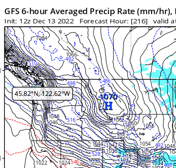
First time creating a thread and hoping for a Christmas Miracle! Models have been consistent on a huge cold shot coming in around the 23rd. Like always, the question is if we get any snow with this cold shot. GFS has shown the potentially for multiple rounds of snow, with an initial thumping arriving with the cold. CMC has the cold, but the system isn't amped up and we have some snow showers in the area. Euro has shown the system on the 23rd, but currently is cold and dry as of 00z 12/16. Regardless if any snow pans out, the cold looks to be real and potentially record breaking. Highs in the teens will be common from the 24th-26th with single digit (and sub-zero lows with snow pack). Below is the eye candy from the 12z GFS.

After that run, no where to go but down for the eastern 1/2 of Tennessee. lol That said, I really hope to have to eat these words.
-
27 minutes ago, Carvers Gap said:
No complaints w/ the 12z GFS.
lol. Quote of the year from an east TN perspective….
-
2
-
2
-
-
Regardless of snow or no snow from the 23rd through the 28th, I'm happy for the ski resorts. Looks like they will get off to a banner year and have plenty of great weather to make snow. After a few crippling duds the last 5 years, I'm glad to see them have an opportunity to get off to a good start.
-
2
-
-
Modeling shows what minor changes means for overall potential in the 6-10 day and beyond. Northern stream further southwest, southern stream a touch slower and further north/west........ Good steps in the right direction.
I'm not ready to give up on the system for Monday night and Tuesday yet either. Modeling has slowly been bringing this back around and I think it's possible a light event occurs somewhere in the southeast/mid south. We are within 120 hours, so it's probably going to have to start taking bigger steps soon............... In the words of Jim Carey from Dumb & Dumber............... "so you're telling me there's a chance"
-
4
-
3
-
-
35 minutes ago, Carvers Gap said:
At 10 days out, lots of room for multiple changes. That said, cold is likely going to be in place. Precip has increased of late - it is raining today and less drought. Drought seems to begat drought. Good to see that waning. Northern stream clippers are likely to be missed. Lots of wiggle room right now.
The biggest unknown (i.e. wildcard) IMO is the energy traversing the northern gulf of Mexico around days 6-8 and how it interacts with the northern stream energy once near/off the SE coast. The modeling is keying on a piece of southern energy being captured around FL to off the east coast and pulled northward . IF (big if, but time for modeling to miss significantly for better or worse) the piece of energy captured is in the northern gulf vs the FL/SE coastline, it changes how things play out. As shown on the CMC and Euro, the wavelengths are just a bit off.......... but it's close enough to keep me interested.
Also, like mentioned........... there's possibly an imbedded northern stream piece of energy somewhere that may show up once the cold is established.
-
6
-
-
5 minutes ago, Carvers Gap said:
So the take away from 12z so far is this.....Remember when the polar vortex got trapped under the block, but modeling lost it?
I kinda hope that DOESN'T come down the front range of the Rockies............ eek.
-
3
-
-
3 hours ago, Runman292 said:
Good morning, everyone. It's been a while since I've last been on here. I'm sorry that I haven't been posting since last winter, but I've had a pretty rough year. In February, I started getting daily headaches and migraines out of nowhere. I've had a few migraines that have mimicked strokes, which was really scary. On top of that, my wife had a "widow maker" heart attack at the age of 33 in June. I'm hoping that 2023 will be better for me and my wife, and that we get a lot of snow this winter.
Best wishes for better health in the year to come. Glad to have you back.
-
3 minutes ago, snowmaker said:
Pulling for all but that track would smack me good. East Tenn would be in ice it looks like. Hopefully we all get the right track for snow. I have to say the possibilities have me excited.
The pattern as shown would likely be a better one for you sooner than for the plateau and points east in TN.
This is a lot of speculation of course and is based on how similar patterns have behaved, but a pattern like the one shown will usually hit areas from Arkansas to west (and possibly middle) Tennessee before our area. As the boundary presses south and east we'd wait for a follower to have our fun. If the pattern fully matures as shown on the ensembles, it wouldn't surprise me to see a larger part of Tennessee have a winter opportunity.
I guess what I'm saying in a nutshell is you could potentially have fun toward the front end of the pattern change and also other opportunities as the pattern matures, before the pattern shown runs out of gas and then we all wait for the next iteration of a pattern that could produce a winter system for the southeast.
I grew up in Gallatin, so living northwest of Nashville puts you in a good spot as compared to areas to your south and east.
-
5
-
-
Just glancing at the GEFS out through 300.................... on TT. Pattern looks good to possibly great, although that doesn't mean we have to score here in the Tennessee Valley. Near perfect patterns can have misses. It's something we do very well.........
Massive west based -NAO will likely linger a bit more than shown (LOVE the look of the highest heights centered around Baffin Bay - it's a good location for our area if you want the possibility of winter). The move to a -EPO, -AO and +PNA as the pattern progresses makes sense given what I'm seeing. This could introduce cross polar flow at some point.
What we know at this point is the likelihood of a winter event in the southeast is on the rise. Figuring out which threat may prompt a dedicated thread is still up for debate. I'm just looking forward to having something to track. That said, I don't want any part of an ice storm.
-
4
-
 2
2
-
-
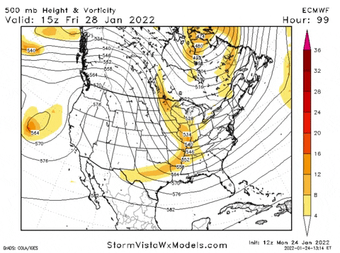
The evolution of the blocking on the 6z GFS is one of the most extreme events I have seen at 500 since I started following modeling.
-
8
-
-
11 minutes ago, Met1985 said:
Yeah the euro is definitely showing a more prominent cold storm for sure.
The energy dives in and is negatively tilted (versus not on the last run) over the central TN valley as compared to the prior run. LONG way to go at 168 hours out....
-
4
-
-
Let's get this party bus rolling. At the very least it might roll in the mountains.
-
2
-
-
On 10/26/2022 at 2:21 PM, Carvers Gap said:
Nah....I take full credit for the massive warm flip in modeling. Just dig back a few posts and you will see the culprit post around Oct 10th. Hot take on my part!!!
I wasn't going to say anything............. lol Hope everyone has been doing well. Looking forward to the changing seasons.
-
3
-
1
-
-
1 minute ago, Holston_River_Rambler said:
Well, that didn't age well in the time it took me to look at the qpf maps, lol. But man that energy interaction just screams big storm to me.:
I'll take it's move towards the GFS as a win at 12z though!
It does me too, but for the midatlantic and northeast............. unfortunately! :-(
-
1
-
 1
1
-
-
2 minutes ago, Carvers Gap said:
The 12z GFS was a strong westward jog of the entire system. The bigger problem is that the STJ has almost a couple of pieces of energy which fire in the GOM. It is almost like modeling is not quite sure which piece to run up the coast. I think this "should" be a very consolidated system and less strung out.
I noticed that. At 500 it looked much more consolidated. I was a bit confused to finally switch to the surface and see multiple areas trying to develop low pressure.
-
1
-
-
1 minute ago, Carvers Gap said:
12z GFS has the nor'easter. With continuity now on the GFS, looks like we have a storm to track this weekend. Now, we need a westward trend which "I think" could be accomplished with a stronger system. My guess is that as modeling finaling dials this in(sees it), it could be a very strong storm. Right now, E TN scores off the northern system and also gets a little bit of a deformation band deal as the storm goes by. We are probably going to see several variations of this on modeling.
We need a quicker phase further southwest. Looks like what becomes the primary energy is off the east coast and it gets going a little late. Still a BIG storm and the upper MA to the northeast would get raked. Just nice to see a big storm showing on the east coast. Hope the individuals show the potential there for a quicker, further southwest phase.
-
2 minutes ago, Silas Lang said:
The Canadian is a little closer than the GFS; the low is more on the way out east with high pressure on the way, while the GFS has it north of the other low.
Canadian vaporizes a nice piece of energy in the southern branch. From closed to pretty much gone in less than 24 hours. Will need to watch this one if we have a closed piece of energy at 500 in central Texas.
-
1
-
-
5 minutes ago, Carvers Gap said:
And man, it just stalls off the coast. Whew!
This is why I don't trust the dry looks on modeling. The MJO does not support a completely suppressed pattern. No idea if that is right or even close to it...but that is a really big storm. No way modeling has that nailed down at 200 hours. Could be gone on the next run. That said, modeling is from time-to-time seeing coastal genesis of big lows. Sure, we could get caught between the northern stream sliding stuff to our north and the STJ sliding stuff below us. BUT, if those two every sync...that run is an example of what could happen.
Sot, that is two storms next week to watch. One is mid-week and has a marginal temp profile. It actually looks good on WxBell's stuff. Then, there is the weekend storm potential after that.
Lows around the lakes are no bueno and the best way to wreck marginal thermals. I feel like it's only showing snow because of the time of arrival in the early AM hours. That said, it's nice to see blue on the map.
And the follow up bomb is pretty. We might have to go find people in eastern NC if that happened. lol
-
1
-
1
-
-
3 minutes ago, Carvers Gap said:
During the last three storms, it seems like the western envelope of modeling at this range has generally been correct IMHO. Anyone see that differently? Seems like all 3 storms had sharp northwest trends for 2 days worth of model runs, then jogged back the opposite direction by maybe ~10-20% of that mileage. But for now, we need to get that storm on all three globals. It is on 2/3.
At least for east TN, this one has quite a bit more potential than the last. Cold air already in place. Overrunning to Miller A vs Miller B into a marginal airmass, etc…..
-
4
-
1
-

Historic Christmas Cold & maybe snow?! Dec 23rd-30th
in Tennessee Valley
Posted
Agree. Here in east TN, the Morristown NWS office at times has to see the snow falling before making the type of statement Nashville made. lol
Complicated evolution coming up. Northern stream systems are notorious to throw wrenches in things, especially when there’s the potential of a phase and especially when there is a handoff of energy to occur. Probably wise for Nashville to at least mention it. As they say, the coming cold will be so sudden, even a small amount of snow/ice could prove to be a problem in such a populated area as Nashville. There have been SO many move to that area, it wouldn’t surprise me if that factored in to the decision to make the statement.