ariof
-
Posts
674 -
Joined
-
Last visited
Content Type
Profiles
Blogs
Forums
American Weather
Media Demo
Store
Gallery
Everything posted by ariof
-
Thanks!
-
Wasn't the December 2020 storm a weak low setup that put that insane fronto band over CNE (and then all evaporated with one of the Grinchiest Grinches a few days later)? That setup was different, of course, without the huge storm impacting the SE, and came more up the coast, but might this have some kind of meso front that dumps 30" of fluff somewhere?
-
Also of interest: the impressive cold snap modeled. Record for BOS for consecutive days AOB 32: 16 ending 2/3/1961, 2/2/1918 15 ending 2/20/2015, 1/15/1970 14 ending 12/30/1989, 2/5/1905, 2/10/1901 13 ending 1/7/2018, 1/28/2005, 12/23/1963, 1/23/1893, 2/5/1881 Verbatim the 06Z and 12Z GFS keeps BOS below freezing until 2/6, which is 14 days if tomorrow doesn't crack 32°. The 00Z Euro only gets warmer because it tracks a bomb a bit inland. With a bunch of SN this is freeze the river solid weather, and probably gets to the point of disrupting ferries and shipping in the harbor. And the core of the PV settles over BNA, GFS has it going well below zero there later this week.
-
I could watch this all day.

-
"It's bombogenesis, baby!"
-
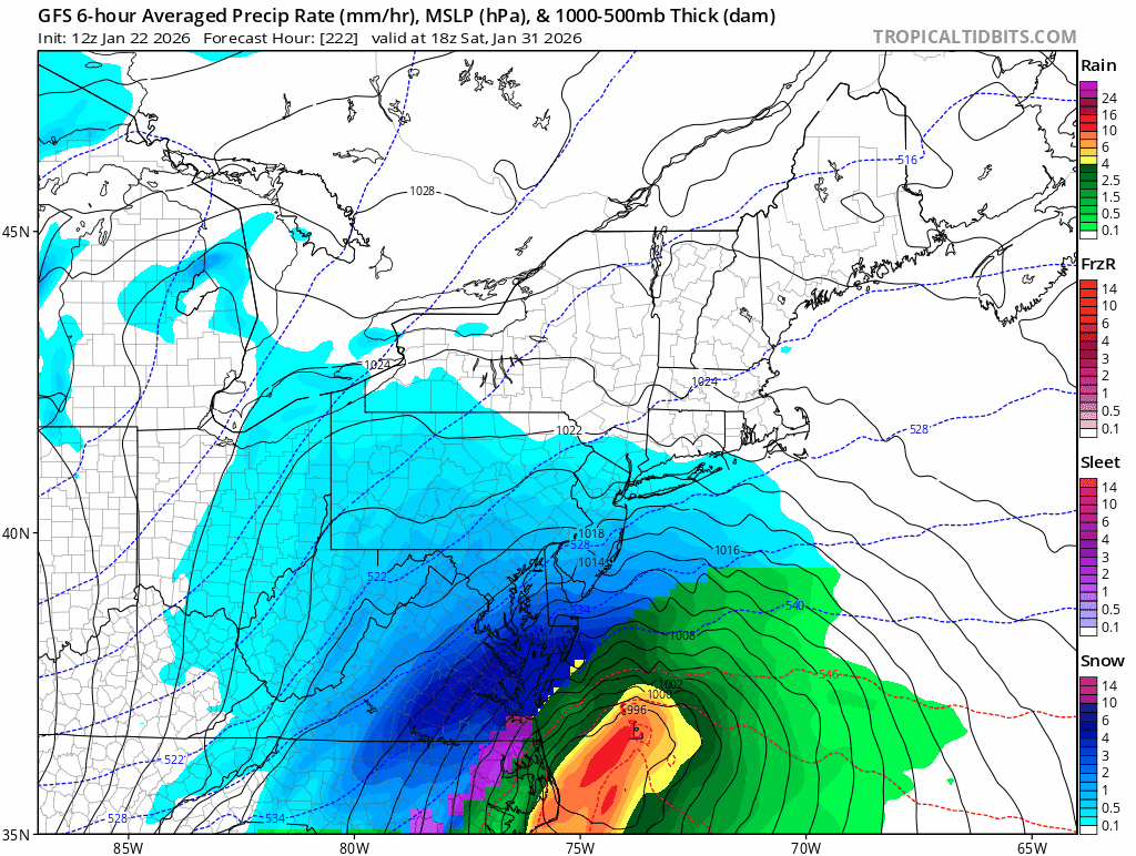
That is an absolute bomb. Storm center goes from 1003 off of the Outer Banks to 972 over ACK in 24h. Pressure at ACK falls 53mb in 24h. Cold airmass in place, coastal front setting up, just textbook. Lock it in / inject it into my veins.
-
Less awesome than pretty much every other model.
-
I have to wonder what Feb 2015 and Dec 1989 would have looked like if this product existed. Both of those were months of -10 anomalies.
-
Given that the largest snowfalls in BOS since 2022 have been 5.5" (2/9/25) 5.4" (2/16/25) 5.3" (1/19/26) 5.2" (12/20/24) I'd expect an underperformance with a storm total between 5.1" and 5.6" Lots of nickels, never a dime
-
Put it in a Feb thread
-
RIP air travel next week … at least it's a relative ebb so there's some slack in the system. DFW, ATL, CLT are in no way prepared for this, and then every northeastern hub gets hit with heavy snow. I guess ORD, IAH and MIA escape mostly unscathed.
-
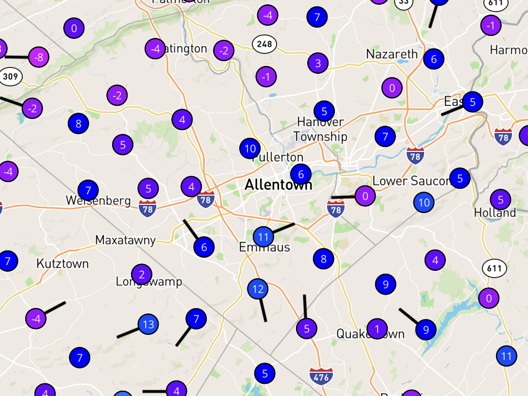
KABE must be in a rad pit but checks out. At 1330Z there are still a bunch of negatives showing up nearby.

-
The ECMWF is parsing the area between SN and RA mostly as ZR, while the NAM/GFS is mostly IP and the CMC somewhere in between. Big difference between 1.5" QPF of ZR and IP.
-
Quick someone crank up the DGEX!
-
Congrats SAV on the op GFS. BUFKIT has 5.5" of snow. Annual record is 4.6, daily record 3.6.
-
Every so often I have a call with a person who happens to be a met in an NWS office in another time zone. After a couple of tries figure out a time for the call I said "wait, we both speak UTC" and now we solely communicate our times for this in z and it hasn't failed yet. I tried to do this in other domains and let's just say people get confused.
-
First Legit Storm Potential of the Season Upon Us
ariof replied to 40/70 Benchmark's topic in New England
I mean, 12,000 years ago the ice sheets were still retreating not far into Quebec, the shoreline was further out and there were big glacial lakes to the NW so … I assume this is "given current climate conditions." -
First Legit Storm Potential of the Season Upon Us
ariof replied to 40/70 Benchmark's topic in New England
I believe this is called the Theory of DGEX -
First Legit Storm Potential of the Season Upon Us
ariof replied to 40/70 Benchmark's topic in New England
If Reggie verifies that's a nice snowy Pats game. -
The record low max for Boston is 2. For the airport it's 6 (1943, 1968). 10 days below 10 since 1936, three of which occurred in 2004. So yeah, I'm skeptical this verifies.
-
Rime up there is legit. I worked down the hill from KMWN at Lakes of the Clouds in the fall many years ago. When we closed up the hut for winter (last full day of service was the equinox) we had BN wx blow in. The summit had a high of 26, low of 22, even 1000' below we were below freezing the whole time, with an average wind speed of 60 mph and gusts up to 84, meaning that it was pretty constant the whole time. And we were in a cloud almost constantly, being blown at us at 60 mph and sticking to everything (meanwhile it was 60° and sunny in the valley). We had a foot of rime on anything exposed to the NW winds, which included the chain link fence around our compost (which we had to work on) which became a wind break, but also the rime blew into the generator, which ran for a few minutes and then choked, and coated our solar, so we had pretty minimal power. It made for interesting working conditions but we muddled through. (A week later it was 55 and sunny and I'm not bitter about that at all.) But yeah, the rime up there is cool, and it's often okay for hiking on some of the trails because the relatively flat tread doesn't get coated but the more vertical rocks around are.
-
And a larger point: you're flying at 500 mph through the air in a tin can for pennies on the dollar compared with what it has ever cost to travel. A lot of people's grandparents immigrated in steerage (if they were lucky, too many people's ancestors were chained up in the bottom of a ship), which was a week or more belowdecks on a ship for most of their life savings to cross an ocean and now people complain that in the summer a roundtrip airfare might cost a couple of days' salary and they might have to change planes in Newark. A number of years ago I was flying back from Chicago and there was wx; basically a line of TSRA from YUL to ATL, and the entire East Coast was hosed (the first dozen-or-so pages of this thread). The guy before me in line waiting to get rebooked after our flight was canceled screamed at the gate agent about how horrible she and her airline were and how he couldn't believe what terrible service they had, etc, rather than, you know, appreciating that he was going to get to New York in two hours from Chicago most of the time, and sometimes wx dictated that it might take longer. Like, dude, your grandfather would have been waiting for an overnight train, and paid dearly for it. He stormed off, she was waiting for her computer to update and I apologized for my fellow passengers. "It's okay, he's in a middle seat tomorrow afternoon." Then I got my boarding pass for a first class seat the next morning. But anyway, we have a cognitive bias towards remembering outliers. We remember the hits, but we don't remember all the misses. Just because we're frustrated that we haven't shoveled a bunch of 240h modeled snow doesn't mean we've always had 240h model snow to shovel.
-
Nationwide, too. Local maxima for snowfall: 42" in the Cascades 2" in the Sierra 33" in the Rockies (up in the Bitterroots) 28" in the UP 49" in Tug Hill 28" in the Whites Peak winter climo and it is quite dry basically outside the LES belts.
-
Oh yeah people there are real proud when it gets cold. And it gets colder with each telling. Duluth hit -39, Embarrass 56, Tower 60. Although people swear they hit -66 if you ask around. Both Twin Cities newspapers had banner headlines that it reached -60 200 miles away.
-
Sure and if that verified then MSP would see its: First -20 temp since Jan 2019* First -30 temp since Feb 1996** First -35 temp since Jan 1888*** Lock it in. * At almost 7 years since -20, it's the longest >-20° there; previous 5-year streaks ending 1961, 2004, 2009, 2014 ** 30 years is by far the longest such run for -30°, three others at 19 years ending 1935, 1962, 1996 *** -41° in 1888 is the record and the most recent <-35° of four occurrences. -34 did occur in 1934 and 1970.