

WVclimo
-
Posts
4,804 -
Joined
-
Last visited
Content Type
Profiles
Blogs
Forums
American Weather
Media Demo
Store
Gallery
Posts posted by WVclimo
-
-
8 minutes ago, Eskimo Joe said:
Just checked our Keedysville site in Washington County and the 2 inch soil temp is down to 32 degrees.
Could you please post the link one more time ? Thought I had it saved.
-
4 minutes ago, clskinsfan said:
GFS looks awesome for the Northern Shenandoah Valley and the Panhandle. Heavy snow bomb during the daylight hours. Sign me up. Very similar to the RGEM with total qpf:

That’s a lot of precip falling in a relatively short time. Hoping the Euro steps up its totals soon.
-
 2
2
-
-
A little over 24 hours from onset, and the latest progs indicate my yard could have anywhere from 1 to 6 inches on the ground tomorrow afternoon.

-
 1
1
-
-
Winds died off and the temp fell to a frosty 16° here under clear skies.
-
Afternoon update from LWX bumped up HGR and MRB to 5-8”

-
1
-
-
Flurries here.
-
1
-
-
Early call from NWS

-
 2
2
-
-
14 minutes ago, SnowBeach said:
Lots of uncertainty today. From my perspective, living in SEVA trying to decide if I should pull the trigger on a cabin in the Luray area for a chase. Happy for the something to track within the state this year, but not excited about a sloppy solution or bust driving all that way. Would love the input from the seasoned vets and Mets on this area.
Edited to add: willing to wait until 12z tomorrow to make a decision.
I did some hiking this afternoon on Skyline Drive near Luray. Surprised to see that shaded areas on north-facing hills had some snow cover. I think that area should do well on Saturday.
-
2
-
-
-
Are today’s CIPS analogs still showing Jan 1996, Feb 2010, Feb 1983 and Jan 2016 for Saturday ?
")
-
5
-
-
It’s rare that my yard gets a 6” snowfall and DC gets shutout in the same storm. Other than a couple of events in late March, and mid-November 2018, may have to go back to December 2012 to find such an event in the winter. Gotta believe if it snows that much here, the Metros get into some of it also.
-
5
-
-
4 minutes ago, Heisy said:
What also kind of blows is we’ve trended now towards a much weaker wave. So even those who are in the all snow region aren’t looking at substantial substantial amounts. Yea 5-10” is nice, but models were throwing out 12” yesterday
.It’s now modeled to be moving a lot faster, also reducing QPF potential. Barely an 8-10 hour storm now vs what was showing the past couple of days.
-
1 minute ago, BristowWx said:
Actually that is fun. Those are some dates that spark a big smile
lol that has the 4 largest snowstorms I’ve ever experienced and a few other one-footers
-
4
-
-
9 minutes ago, osfan24 said:
I don't know if it is the metro or what. Obviously, it's probably even worse now than when I went there since the school and especially surrounding area has become far more built up than it was in the early and mid 2000's. But you would think with some of the green space there that it would help mitigate some of it.
Isn’t the elevation around campus between 100’ and 200’ above sea level ? I lived in College Park for several years, near the beltway, and I think my yard was under 300’.
-
6 minutes ago, mattie g said:
Just got back from three days at Wisp with four other families. Tapped out for that time and just kept busy and happy, even if it was 75 and pissing down rain on the mountain when we got there. Good thing is that it started snowing last night and we woke up to 1-2” on our cars this morning.
Anyways…did I miss anything interesting?
Some models started showing the possibility of N. Pacific ridging in the long-range, which should effectively end any chance we have of seeing a good winter. Also, it might snow on the 7th.
-
1
-
2
-
-
1 minute ago, EastCoast NPZ said:
What a nightmare. To think what that would be like today.
Depression-era weenies were probably complaining that it would never snow again.
-
1
-
-
34 minutes ago, EastCoast NPZ said:
Man, that 1930

You would have loved that year. 59 days at MRB above 90°. 33 of those above 95, and 17 days that the high temp was over 100 !
From 7/19 through 7/30, the “coolest” high temp was 98.
-
2
-
 1
1
-
-
2 minutes ago, 87storms said:
If you’re big game hunting, then yes, winter is half over on Feb 8, but I’d like to see a cdf for mean snow. The biggest issue so far this year isn’t the lack of snow here, but what seems like most of NA. I’m not even tracking snow here anymore…I want to see legitimate snowstorms showing up for areas to the nw.I’m with you in wanting to see snow showing up more extensively in the CONUS.
But from memory, most of our Nino snows come in big dumps, often without much in between. That’s been my expectation for this season ever since this ENSO+ took off.-
1
-
-
9 minutes ago, dallen7908 said:
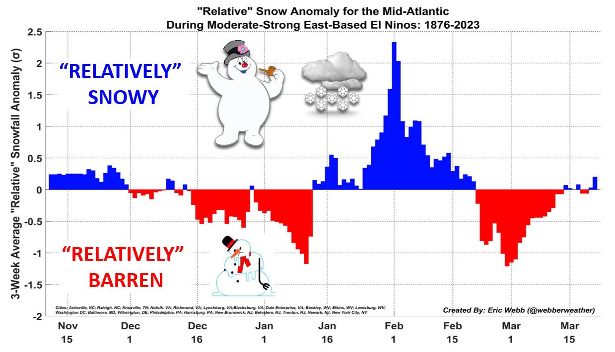
Thanks for the plot. Thoughts: 1) I wonder where he got the snow data for 1876-1895 or so. 2) February 8th for the mid-point - a few days later than I expected but certainly in line with memory. 3) The changes in slope are interesting do they just fall out of the data or did he do some piece-wise fitting? 4) The snowless gaps in late December and mid-January are a bit sad. 5) It looks like prime time is January 20th - February 20th - no surprise there! 6) I wonder how many winters are classified as moderate-to-strong El Niño winters and how different the plot would be during other years. Would the peak be a week earlier?
All good points/ questions. He also produced this, if it helps explain the graph lol.

-
10
-
-
Looks like Martinsburg airport will finish with the 4th lowest annual precip total since 1926. That’s after a late save with 5.84” in the past six weeks.
21.41” - 1930
26.32” - 1991
27.75” - 1969
28.25” - 2023
-
2 hours ago, WxUSAF said:
Positive vibes from (checks notes) Eric Webb?
This is also from Eric Webb. A helpful reminder for the impatient among us.

-
8
-
1
-
-
13 minutes ago, Eskimo Joe said:
I'm out. Enjoy the false promises in the long range. I was hoping I'd be wrong and we'd get snow this winter, but it's obvious there's no chance. I still hope I'm wrong and get mercilessly bump trolled in a few weeks, but we're making an honest run at a winter as bad as last year. PSU was right, our snow climo is forever screwed.
lol. December 27th. Congrats !
-
 1
1
-
-
19 minutes ago, stormy said:
The historic Jan. 66 blast didn't begin until Jan. 22. During the next 2 weeks we had nearly 40 inches of snow. Everybody needs to settle down and be patient!
1987 had its first snow on January 22 also, and DCA ended the season with 30”+. Same date in 2016 as well.
-
3
-
-
13 minutes ago, EastCoast NPZ said:
Is there any chance any of this precip this week is snow at Cannan? I'd like to take advantage of the kids being off school and take them tubing/sledding. But the NWS site doesn't seem to give their forecast; I'm (hoping) it's giving a forecast closer to the local office. Because that forecast looks too warm.
Looks like Friday or Saturday would be your best days. From the NWS point-and-click:

-
1
-
1
-


January 6-7 Storm Discussion: we’re due?
in Mid Atlantic
Posted
Point & Click forecast for my yard raised accumulations to 3-7” for the daytime tomorrow with another 1” in the evening.
WSW update though says 2-5” with up to 1/4” of ice.