

WVclimo
-
Posts
4,804 -
Joined
-
Last visited
Content Type
Profiles
Blogs
Forums
American Weather
Media Demo
Store
Gallery
Posts posted by WVclimo
-
-
Closing in on an inch of rain in the bucket. Snow cover has taken a beating but is still hanging tough.

-
 7
7
-
-
I’ve mentioned this before here, but my memory of having driver’s ed in high school in western MD was when we took the car out with heavy snow falling. As I was driving up I-68 climbing Martin’s Mt, the instructor told me to stay in the ruts created in the snow on the road by tractor trailers ahead of me.
There was no thought of not sending us out into a snowstorm. Times surely have changed lol.
-
2
-
-
Cumberland reporting heavy snow. Webcams look great there. Been a good week for my hometown with 7” on Saturday and now this storm.
-
3
-
-
Forecast low for tonight is 29. Currently 26 with some cirrus moving in.
-
Calm winds, clear skies and a rising baro at 30.43”.
31° and falling fast. Still have about 2.5” of snow depth. If the precip gets in by sunrise, might get slick for a time here in the a.m.
-
1
-
-
Dec 11 - 0.1”Jan 6 - 4.8”
-
2
-
-
Storm is ending as some light freezing rain. 4.8” total snowfall.
-
15
-
-
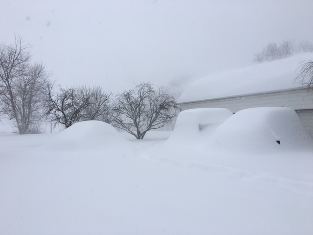
lol at downplaying Jan 2016. Here are a few of the vehicles in my driveway after that storm.
-
23
-
-
3 minutes ago, Solution Man said:
Enjoy, that’s a deep winter day
Thanks man. It’s been a beautiful day here. Beef stew in the crockpot, corn bread in the oven, and icy cold IPA’s for the football later.
-
9
-
-
Heaviest snow of the day now. That and freezing fog has reduced visibilities to less than 1/4 mile.
North wind at 13 mph causing some slight blowing snow. 4” on the ground.-
17
-
-
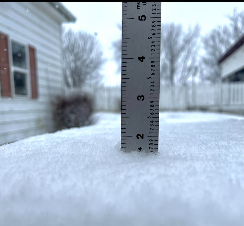
Just passed 3”. I measured a total of 4.3” all of last winter.
-
13
-
 1
1
-
-
Another 3/4” in the past hour. 2.5” total. Moderate snow at 30°. Neighbor who takes care of our road just did his first plow of the day.
-
9
-
-
Just now, WVsnowlover said:
Wow that's awesome congrats! We got a mulch topper here in southern Jefferson County and are just rain with a few sleet pellets now.
Been watching that mix line on the CC radar. It’s approached my part of the county a few times but the wedge is holding tough here. Hopefully it can strengthen if heavier precip comes your way this afternoon.
-
1
-
-
Picked up an inch in the past 45 minutes. Still moderate snow. 1.6” on the snow board.
-
13
-
-
17 minutes ago, Chris78 said:
Can anyone confirm if those heavier returns just SW of Martinsburg is snow or sleet. Seeing some yellow returns.
It’s pouring snow here now. Big flakes. The kind of snow that piles up quickly. About 0.50 mi. visibility. Still 29°.
-
5
-
 1
1
-
-
Flakes getting bigger now as the intensity picks up. All surfaces including paved roads are covered. Up to 29°.
-
7
-
-
My location does exceptionally well during nights with effective radiational cooling. Sheltered river valley spot surrounded by farms and orchards.
Usually holds onto the cold at the surface as well in these types of events. Until winds begin to mix everything.
-
1
-
-
First flakes falling here. Just needles, but definitely all snow. 27°.
-
5
-
-
5 minutes ago, aldie 22 said:

I second the suggestion of the walking mall in downtown Winchester. It’s beautiful in the sleet.
-
 5
5
-
-
After holding steady at 22° most of the night, temps have just begun to tick up. Currently 23/19. Light breeze stirring from the NE at 5 mph.
-
1 minute ago, WeatherShak said:
What’s your exact location in WV?
.I’m in Falling Waters. 1/2 mile from the Potomac River in northern Berkeley County.
10 miles SW of HGR. 10 miles NW of MRB.-
2
-
-
Just realized that LWX did an intermediate update at 7:00 and increased snow accumulations here from the 2-5” they put out this afternoon to 4-8” now. Also added language to the WSW saying snowfall rates could reach 1-2” an hour tomorrow afternoon. Further, they say precip should remain almost all snow.

-
9
-
-
Skies are still clear. Down to 22°.
-
2
-
-
25/16 under clear skies. Lost 10° in the last two hours.
-
4
-


Tuesday, January 9 Rain and Wind Storm
in Mid Atlantic
Posted
Not a whiff of a breeze here. Winds were variable at 7 mph, but have now gone calm. Gonna need something to break the wedge.