

canderson
-
Posts
21,292 -
Joined
-
Last visited
Content Type
Profiles
Blogs
Forums
American Weather
Media Demo
Store
Gallery
Posts posted by canderson
-
-
Latest forecast has the Susquehanna at 19.1” in Harrisburg which is good news.
-
It's absolutely pouring rain downtown HBG again.
-
16 minutes ago, djr5001 said:
My daily numbers since Saturday are 3.06", 1.13", 1.81", and 2.07" for a 4 day total of 8.07" and its crazy that even 8" is not close to the top reported numbers in the area.
Interesting that Camp Hill/City Island have about 1.5" more - what weird totals. You have any issues with basement flooding or anything?
If anyone around HBG needs help, just shoot me a PM and I'll do what I can to help you out.
FWIW 322 is likely to close today going toward Hershey, and 422 as well.
-
18 minutes ago, maytownpawx said:
How high must the river get before you would be affected? You're close to Front street, correct?
My house is in no danger of flooding, it was a block and half away during Agnes in 1972 so if my house floods the capitol will be partially underwater.
My business however ... not so lucky.
-
Two park rangers and a NWS truck were on Riverfront Park and Front and Calder in HBG this morning doing some river gauging I believe.
That's maybe not a good sign.
-
Um the Swatara is f’d. Boat evacuations in Hershey.
-
3 minutes ago, Jns2183 said:
Haha, was it you Sunday who tempted the weather gods by saying the flash flood warning was a fail because it barely rained that day?
. ProYea lol. Then around 9 pm it started raining and hadn’t really stopped
-
It’s like it heard me say it might miss ...
-
I might need a canoe to make it to work. Literally,
-
 1
1
-
-
... it didn’t miss.
-
12 minutes ago, Jns2183 said:
Looks like we are about to get slammed again

. ProIt might miss the city to the west ... will be super close.
-
^ Um that’s bad.
-
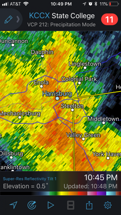
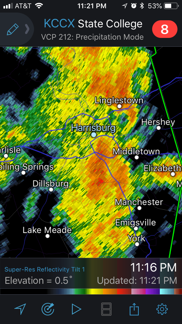
Hey look it’s dark as night and torrents of rain are back.
-
As of 1 p.m. my friend in Camp Hill - directly across the river from my house in HBG - had 9.5" rain since Sunday.
-
WPC Target again for 2-4” additional today
Mesoscale Precipitation Discussion 0531
NWS Weather Prediction Center College Park MD
1245 PM EDT Tue Jul 24 2018

Areas affected...Northern Maryland/Delaware into central
Pennsylvania, far western New Jersey and southern New York

Concerning...Heavy rainfall...Flash flooding likely

Valid 241643Z - 242130Z

SUMMARY...Flooding and flash flooding appear likely over the next
3-5 hours from northern Maryland/Delaware into portions of central
Pennsylvania, western New Jersey and southern New York. An
additional 2-4 inches of rain with rainfall rates of 1-2 in/hr
through 21Z can be expected.

DISCUSSION...Regional radar imagery at 16Z showed a NNW-SSE axis
of heavier rainfall in the vicinity of the northern Chesapeake Bay
with rainfall rates of ~1 inch in 15-20 minutes per
Wunderground.com observations. The broken line of heavy rain was
coincident with weak low level confluence beneath locally
diffluent flow aloft given the presence of a narrow upper level
ridge axis along the East Coast. The line has been gradually
shifting to the north and east which has prevented potentially
much higher rainfall totals over the past 2-3 hours but the
northern Mid-Atlantic region is saturated from a widespread 4-10
inches of rain which has fallen over the past few days.

CAPE values across the northern Mid-Atlantic into southern New
York are generally less than 1000 J/kg given cloud cover, but
given the moist environment, higher CAPE values are not needed to
support heavy rainfall rates. Nonetheless, clearing over eastern
Pennsylvania may allow for increasing instability through the
afternoon along with the development of new convection. Little
change to the synoptic environment is expected over the next
several hours which will keep precipitable water values over 2.25
inches and 30-40 kt 850 mb flow from the south helping to support
repeating and brief training of heavy rain cores. Given the
antecedent conditions, flooding and flash flooding are considered
likely.
https://www.wpc.ncep.noaa.gov/metwatch/metwatch_mpd_multi.php?md=0531&yr=2018
-
Nothing out yet from CTP but HBG fire officials are concerned about the Susky hitting 22' or so and not the 18' currently forecast.
For those unfamiliar, that difference makes a massive difference in the problems it causes. At 18' it's fairly minor basement flooding and City Island parking lot flooding. At 21.5' it breaches the banks in Shipoke and near the Governor's Mansion.
-
New warning just terrified my office as all phones went off at once.
lash Flood Warning
PAC041-043-071-133-241745-
/O.NEW.KCTP.FF.W.0023.180724T1454Z-180724T1745Z/
/00000.0.ER.000000T0000Z.000000T0000Z.000000T0000Z.OO/

BULLETIN - EAS ACTIVATION REQUESTED
Flash Flood Warning
National Weather Service State College PA
1054 AM EDT TUE JUL 24 2018

The National Weather Service in State College PA has issued a

* Flash Flood Warning for...
  West central Lancaster County in south central Pennsylvania...
  York County in south central Pennsylvania...
  Southern Dauphin County in south central Pennsylvania...
  Northeastern Cumberland County in south central Pennsylvania...

* Until 145 PM EDT..

* At 1045 AM EDT, Doppler radar indicated an area of heavy rain
  moving into the warned area. Up to eight inches of rain has
  already fallen in this region over the past few days, with
  flooding ongoing in many locations. An additional 1 to 3 inches of
  rainfall is likely by early afternoon. This will increase
  the severity of the flooding.

* Some locations that will experience flooding include...
  Harrisburg, York, Lower Allen, Hanover, Hershey, Colonial Park,
  Weigelstown, Elizabethtown, Progress, Mechanicsburg, Middletown,
  Camp Hill, Palmyra, New Cumberland, Parkville, Red Lion,
  Linglestown, Enola, Steelton and Spry.

The Codorus Creek is already above flood stage, and this will
exacerbate flooding problems along the creek. Additional rapid rises
on the Conowingo and Little Conowingo Creek are also expected.
-
I'm now beginning to worry a bit about the river, though the lack of heavy rain in the northern mountains probably saves us.
-
21 minutes ago, sauss06 said:
Bad.
That’s terrible - was hoping just a kitchen issue.
-
5 minutes ago, sauss06 said:
reason for my 2 hours of sleep.
Currently heavy rain in Da Burg
How bad is it?
-
1.5” from 12-1 am apparently. No clue otherwise.
Its really bad around here.
-
12 minutes ago, TheDreamTraveler said:
Yeah this is really starting to remind me of the September 2011 flooding. Do any of you think this will get close to the top 3 worst flooding for our area? I know the 2011 flooding was the 3rd worst ever.
The Susquehanna is not going to come anywhere near 2011 numbers. 2011 featured Irene then Lee - something like 18” rain in a week.
-
This is up there with the hardest rain I’ve seen since moving here. My 5” rain gauge is gone, guess it filled and fell over.
-
 1
1
-
-
Annnd incoming


Spring 2018
in Upstate New York/Pennsylvania
Posted
Oh hey it’s pouring again - it’s like a broken record.