

canderson
-
Posts
21,395 -
Joined
-
Last visited
Content Type
Profiles
Blogs
Forums
American Weather
Media Demo
Store
Gallery
Posts posted by canderson
-
-
8 hours ago, Jebman said:
I am a couple days from leaving for Hell, Texas, and my life is already descending into Hell herei n VA as mom continues her control freak stranglehold on my poor little life.
It is going to be excruciating for the next 5 years at least.
I wish I did not have to go.
I actually would rather be dead. It would be much better, lol.
This is NOT gonna be fun. It will be Hell on Earth.
Tacos and a #4 double from Whataburger will save you.
-
My nephew is on the Post Oak (TX) team. They should whip most teams in Williamsport - they’re absolutely loaded.
-
MDT is 16.51” above average year-to-date rainfall as of today.
Wow.
-
That's awesome!
-
 1
1
-
-
59 minutes ago, Voyager said:
That line farther north produced about 3.5" in Reading and Allentown. Parts of the Musikfest festival grounds along the Monocacy Creek in Bethlehem flooded this morning.
Oh wow had no idea. We had mostly right rain but it did get a bit heavy around 10ish. HBg for once missed the heavy stuff - too far west.
-
That line from York to Lancaster was impressive.
-
Newsflash: it’s still raining
-
UPDATE: Thy did survive ...
-
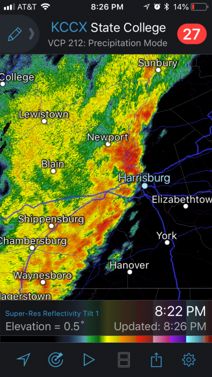
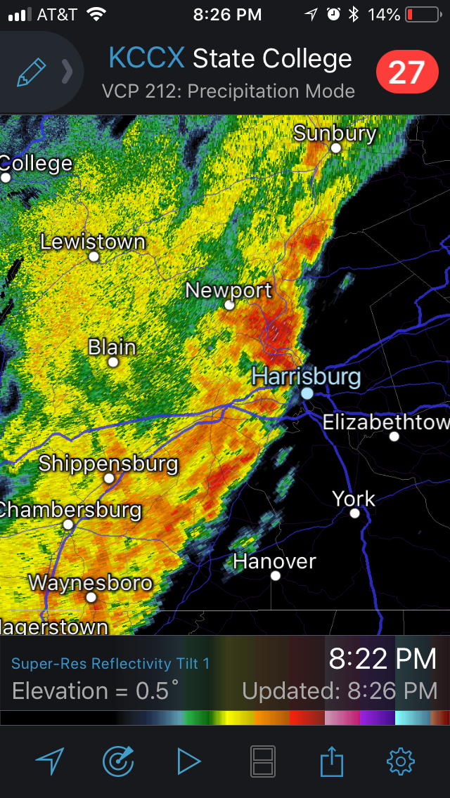
Big line of storms west of a Chambersbirg to Newport Line. Wonder if they can keep it together as they cross the mountains?
-
Wednesday might be interesting with severe wx.
-
Back to the weather - while it's about to pour rain again for a few hours here (nice 20 percent chance of rain we had this morning haha), this is INSANE:
@NWSStateCollege
We have now finalized the 5-day rainfall total for Dehart Dam. 16.75" fell between Saturday 7/21 and Thursday 7/26. That total includes a 1-day rainfall of 8.11" on Tuesday. Crazy amounts of rain! #PAwx-
1
-
-
21 minutes ago, sauss06 said:
so is that why this Meteorologist left the company too? I read all about the others, but she just kinda disappeared.
I believe so; I don't know her at all but have heard she quickly found a new job and bolted.
-
3 hours ago, sauss06 said:
I guess Ann Rodden, the weekend weather person at WHTM is now gone too. What the hell is going on at that station?
Combo of sexual harassment and gender bias. Hopefully Flora's lawsuit goes through and they all win and put them out of business.
-
20 minutes ago, Anduril said:
Well....that was a really sad storm through the carlisle/camp hill area gotta say. Glad we didnt get heavy rain but man did it disappoint in terms of anything. Guess we'll see what next week brings
It looks less and less serious.
-
Thankfully that was a massive nothingburger for the HBG region. No wind at all, light gray skies, light rain for 20 or so minutes. I got .15” at my house.
Very glad we finally caught a break.
-
Is it me or does the system next week look like it's not going to end up being too much of an issue - just random passing showers for a day or two?
-
Oh cool another FFW.
Flood Watch
National Weather Service State College PA
936 AM EDT Fri Jul 27 2018

PAZ057>059-064>066-280300-
/O.NEW.KCTP.FF.A.0012.180727T1700Z-180728T0300Z/
/00000.0.ER.000000T0000Z.000000T0000Z.000000T0000Z.OO/
Dauphin-Schuylkill-Lebanon-Adams-York-Lancaster-
Including the cities of Harrisburg, Hershey, Pottsville, Lebanon,
Gettysburg, York, and Lancaster
936 AM EDT Fri Jul 27 2018

...FLASH FLOOD WATCH IN EFFECT FROM 1 PM EDT THIS AFTERNOON
THROUGH THIS EVENING...

The National Weather Service in State College has issued a

* Flash Flood Watch for a portion of central Pennsylvania,
  including the following areas, Adams, Dauphin, Lancaster,
  Lebanon, Schuylkill, and York.

* From 1 PM EDT this afternoon through this evening

* Showers and thunderstorms will develop this afternoon and
  continue through late evening, with heavy rainfall rates
  likely. Given saturated soil from this week`s excessive
  rainfall, flash flooding may again result.
-
The Susquehanna at Harrisburg crested an hour or so ago at 17’ even and is now falling. The city itself got extremely lucky it was so low prior to Sunday.
-
I don’t like the wording CTP is using in the discussion.
.LONG TERM /FRIDAY NIGHT THROUGH WEDNESDAY/...
Med range guidance remains in fairly good agreement into next
week, all of which track surface high pressure across the state
this weekend. By next week, a deepening upper trough over the
Miss Valley, combined with an anomalous upper ridge off the
east coast, could potentially result in another atmospheric
river setup along the east coast.

A generally dry and seasonable weekend appears likely, as high
pressure drifts across the state. However, can`t rule out a
stray shower each day in association with the passage of a pair
of shortwaves.

Early next week is looking increasingly wet, as deep plume of
tropical moisture overruns an approaching warm front. Med range
models indicate warm front is likely to lift north of the state
Tue/Wed. However, central Pa will remain within belt of
anomalous pwats and susceptible to widespread, diurnally-driven
convection into midweek.

&&
-
I am putting down I ended with 10.75" rain from this event. It likely is off because my gauge was knocked over twice but looking around at totals I feel comfortable there.
The river is quite angry this morning. I'll get some photos or videos after work if the light is OK. If not tomorrow morning I will.
-
I think it’s finaly over ...
-
6 minutes ago, Jns2183 said:
This line is taking its good old time moving
. ProIt’s backbuilt in strength, which I didn’t expect.
-
Just now, Voyager said:
Also, I have this nagging feeling that when it does reach my location, the back edge will be moving faster than the leading edge and it'll be in and out in 15 minutes. If you've watched my posts, the radar, and the general weather pattern in and around Tamaqua, you'll see that it's been this way for years. No matter what kind of event, set up, or season.
Hell, even the worst storm in probably a century (Sandy) was rather benign here. There is definitely something about the geography and topography of northeastern Schuylkill County that tames or prevents any kind of severe event here.
I mentioned this the other day but I’d be very interested in a thermal dynamics study.
The lower Susquehanna Valley for a decade or more has cashed in on all sorts of extreme setups - snow, rain, wind. The exact same spots.
-
21 minutes ago, djr5001 said:
I’m in it now and this is the heaviest I have seen from this whole event
That first cell skirted the city proper - it rained but we’ve had heavier - but it appears our luck(lol) runs out soon,
Spring 2018
in Upstate New York/Pennsylvania
Posted
Fantastic data. Thank you for researching and sharing.