

canderson
-
Posts
21,452 -
Joined
-
Last visited
Content Type
Profiles
Blogs
Forums
American Weather
Media Demo
Store
Gallery
Posts posted by canderson
-
-
I don’t like the wording CTP is using in the discussion.
.LONG TERM /FRIDAY NIGHT THROUGH WEDNESDAY/...
Med range guidance remains in fairly good agreement into next
week, all of which track surface high pressure across the state
this weekend. By next week, a deepening upper trough over the
Miss Valley, combined with an anomalous upper ridge off the
east coast, could potentially result in another atmospheric
river setup along the east coast.

A generally dry and seasonable weekend appears likely, as high
pressure drifts across the state. However, can`t rule out a
stray shower each day in association with the passage of a pair
of shortwaves.

Early next week is looking increasingly wet, as deep plume of
tropical moisture overruns an approaching warm front. Med range
models indicate warm front is likely to lift north of the state
Tue/Wed. However, central Pa will remain within belt of
anomalous pwats and susceptible to widespread, diurnally-driven
convection into midweek.

&&
-
I am putting down I ended with 10.75" rain from this event. It likely is off because my gauge was knocked over twice but looking around at totals I feel comfortable there.
The river is quite angry this morning. I'll get some photos or videos after work if the light is OK. If not tomorrow morning I will.
-
I think it’s finaly over ...
-
6 minutes ago, Jns2183 said:
This line is taking its good old time moving
. ProIt’s backbuilt in strength, which I didn’t expect.
-
Just now, Voyager said:
Also, I have this nagging feeling that when it does reach my location, the back edge will be moving faster than the leading edge and it'll be in and out in 15 minutes. If you've watched my posts, the radar, and the general weather pattern in and around Tamaqua, you'll see that it's been this way for years. No matter what kind of event, set up, or season.
Hell, even the worst storm in probably a century (Sandy) was rather benign here. There is definitely something about the geography and topography of northeastern Schuylkill County that tames or prevents any kind of severe event here.
I mentioned this the other day but I’d be very interested in a thermal dynamics study.
The lower Susquehanna Valley for a decade or more has cashed in on all sorts of extreme setups - snow, rain, wind. The exact same spots.
-
21 minutes ago, djr5001 said:
I’m in it now and this is the heaviest I have seen from this whole event
That first cell skirted the city proper - it rained but we’ve had heavier - but it appears our luck(lol) runs out soon,
-
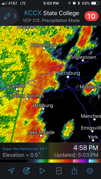
Flash flood warning fir Harrisburg until 9:30.
At this point CTP should issue headlines if it won’t rain.
-
I guess this is the finishing punch.
-
Storms riding up 81 mean business, wow.
-
Oh hey it’s pouring again - it’s like a broken record.
-
 1
1
-
-
Latest forecast has the Susquehanna at 19.1” in Harrisburg which is good news.
-
It's absolutely pouring rain downtown HBG again.
-
16 minutes ago, djr5001 said:
My daily numbers since Saturday are 3.06", 1.13", 1.81", and 2.07" for a 4 day total of 8.07" and its crazy that even 8" is not close to the top reported numbers in the area.
Interesting that Camp Hill/City Island have about 1.5" more - what weird totals. You have any issues with basement flooding or anything?
If anyone around HBG needs help, just shoot me a PM and I'll do what I can to help you out.
FWIW 322 is likely to close today going toward Hershey, and 422 as well.
-
18 minutes ago, maytownpawx said:
How high must the river get before you would be affected? You're close to Front street, correct?
My house is in no danger of flooding, it was a block and half away during Agnes in 1972 so if my house floods the capitol will be partially underwater.
My business however ... not so lucky.
-
Two park rangers and a NWS truck were on Riverfront Park and Front and Calder in HBG this morning doing some river gauging I believe.
That's maybe not a good sign.
-
Um the Swatara is f’d. Boat evacuations in Hershey.
-
3 minutes ago, Jns2183 said:
Haha, was it you Sunday who tempted the weather gods by saying the flash flood warning was a fail because it barely rained that day?
. ProYea lol. Then around 9 pm it started raining and hadn’t really stopped
-
It’s like it heard me say it might miss ...
-
I might need a canoe to make it to work. Literally,
-
 1
1
-
-
... it didn’t miss.
-
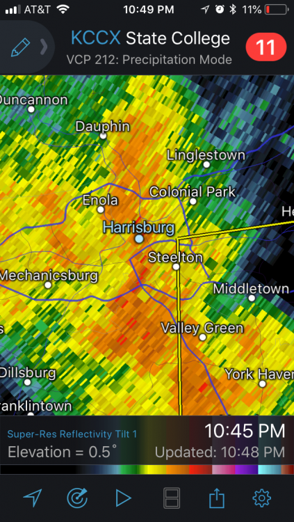
12 minutes ago, Jns2183 said:
Looks like we are about to get slammed again

. ProIt might miss the city to the west ... will be super close.
-
^ Um that’s bad.
-
Hey look it’s dark as night and torrents of rain are back.
-
As of 1 p.m. my friend in Camp Hill - directly across the river from my house in HBG - had 9.5" rain since Sunday.


Spring 2018
in Upstate New York/Pennsylvania
Posted
The Susquehanna at Harrisburg crested an hour or so ago at 17’ even and is now falling. The city itself got extremely lucky it was so low prior to Sunday.