Stormlover74
-
Posts
24,275 -
Joined
-
Last visited
Content Type
Profiles
Blogs
Forums
American Weather
Media Demo
Store
Gallery
Everything posted by Stormlover74
-

Extreme Cold, Snow & Sleet: SECS 1/24 - 1/26
Stormlover74 replied to TriPol's topic in New York City Metro
Not running yet for some reason Went from 36 to 19 in thr past 4 hours -
Extreme Cold, Snow & Sleet: SECS 1/24 - 1/26
Stormlover74 replied to TriPol's topic in New York City Metro
Meh he had it not coming north 2 days ago -
Extreme Cold, Snow & Sleet: SECS 1/24 - 1/26
Stormlover74 replied to TriPol's topic in New York City Metro
No they all lost it 3 days out -
Extreme Cold, Snow & Sleet: SECS 1/24 - 1/26
Stormlover74 replied to TriPol's topic in New York City Metro
Icon slightly better. Need the rgem to hold -
Extreme Cold, Snow & Sleet: SECS 1/24 - 1/26
Stormlover74 replied to TriPol's topic in New York City Metro
It got worse snowfall wise. 3k might've been better but snowmaps aren't loading -
Extreme Cold, Snow & Sleet: SECS 1/24 - 1/26
Stormlover74 replied to TriPol's topic in New York City Metro
If the nam ends up being right then whats the point of using any other model if they all suck at sniffing out warm layers? -
Extreme Cold, Snow & Sleet: SECS 1/24 - 1/26
Stormlover74 replied to TriPol's topic in New York City Metro
Yeah its all funky -
Extreme Cold, Snow & Sleet: SECS 1/24 - 1/26
Stormlover74 replied to TriPol's topic in New York City Metro
Ukie held serve i guess. Its a mess...drier and has snow to Delaware with 552 thickness -
Extreme Cold, Snow & Sleet: SECS 1/24 - 1/26
Stormlover74 replied to TriPol's topic in New York City Metro
Wow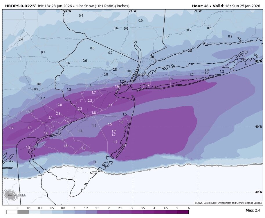
-
Extreme Cold, Snow & Sleet: SECS 1/24 - 1/26
Stormlover74 replied to TriPol's topic in New York City Metro
Hrdps looks great too. Only goes to 18z but has near a foot in south nj -
Extreme Cold, Snow & Sleet: SECS 1/24 - 1/26
Stormlover74 replied to TriPol's topic in New York City Metro
That would be .7 as snow and. 7 as sleet. Would still be like 8 or 9 total since sleet will still add up -
Extreme Cold, Snow & Sleet: SECS 1/24 - 1/26
Stormlover74 replied to TriPol's topic in New York City Metro
Yeah we need that thump to perform if we're getting anywhere near double digits -
Extreme Cold, Snow & Sleet: SECS 1/24 - 1/26
Stormlover74 replied to TriPol's topic in New York City Metro
Its about 30 miles further north which is a huge difference since that encompasses most of the metro -
Extreme Cold, Snow & Sleet: SECS 1/24 - 1/26
Stormlover74 replied to TriPol's topic in New York City Metro
Drier and warmer. 6 runs to go -
Extreme Cold, Snow & Sleet: SECS 1/24 - 1/26
Stormlover74 replied to TriPol's topic in New York City Metro
Looks like a quicker flip to sleet Ala 6z but we'll see if it slows again -
Extreme Cold, Snow & Sleet: SECS 1/24 - 1/26
Stormlover74 replied to TriPol's topic in New York City Metro
Looks great. Snowing nicely at 18z and the mix line still several hours away -
Extreme Cold, Snow & Sleet: SECS 1/24 - 1/26
Stormlover74 replied to TriPol's topic in New York City Metro
Yeah that's what I'm telling people as well. I want to see the nam hold through tomorrow before I'll be more confident in double digits. There's still time for the dreaded last minute northerly shift -
Extreme Cold, Snow & Sleet: SECS 1/24 - 1/26
Stormlover74 replied to TriPol's topic in New York City Metro
Upton warnings out -
Extreme Cold, Snow & Sleet: SECS 1/24 - 1/26
Stormlover74 replied to TriPol's topic in New York City Metro
Average them out its 1.2" -
Extreme Cold, Snow & Sleet: SECS 1/24 - 1/26
Stormlover74 replied to TriPol's topic in New York City Metro
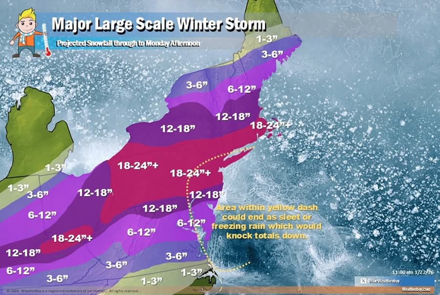
Mt holly Morris on south more for north and west ...WINTER STORM WARNING IN EFFECT FROM 7 PM SATURDAY TO 1 PM EST MONDAY... * WHAT...Heavy snow with mixed precipitation expected. Total snow accumulations between 10 and 15 inches and ice accumulations around one tenth of an inch. * WHERE...Portions of New Jersey and southeast Pennsylvania. * WHEN...From 7 PM Saturday to 1 PM EST Monday. -
Snow Contest January 25th-26th
Stormlover74 replied to WeatherGeek2025's topic in New York City Metro
New York City 8.3 Boston 14.4 Philadelphia 6.8 Washington DC 6.3 Hartford 15.8 Albany 19 -
Cmc has it too..not sure if it comes up the coast yet
-
Crazy how it keeps showing it 10 days out
-
Extreme Cold, Snow & Sleet: SECS 1/24 - 1/26
Stormlover74 replied to TriPol's topic in New York City Metro
Lol like 3 straight runs but the ukie does these weird things sometimes