

Yeoman
-
Posts
3,179 -
Joined
Content Type
Profiles
Blogs
Forums
American Weather
Media Demo
Store
Gallery
Posts posted by Yeoman
-
-
1 hour ago, LP08 said:
8-9am on the euro.
Gonna have to pass on the confessional again
-
 1
1
-
 2
2
-
-
34 minutes ago, arlwx said:
New bunch of WWAs.
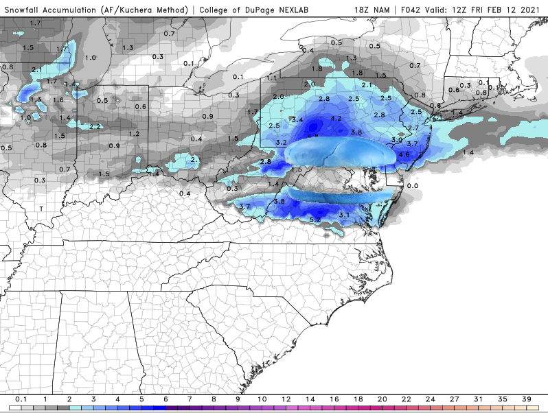
URGENT - WINTER WEATHER MESSAGE
National Weather Service Baltimore MD/Washington DC
647 PM EST Fri Feb 12 2021

Hardy-
647 PM EST Fri Feb 12 2021

...WINTER WEATHER ADVISORY IN EFFECT FROM 1 AM TO 1 PM EST
SATURDAY...

* WHAT...Sleet and freezing rain. Total sleet accumulations of
  less than one inch and ice accumulations of up to one tenth of
  an inch.

* WHERE...Hardy County.

* WHEN...From 1 AM to 1 PM EST Saturday.


 - WINTER WEATHER MESSAGE
National Weather Service Baltimore MD/Washington DC
647 PM EST Fri Feb 12 2021

VAZ027-131000-

647 PM EST Fri Feb 12 2021

...WINTER WEATHER ADVISORY IN EFFECT FROM 1 AM TO 7 PM EST
SATURDAY...

* WHAT...Sleet and freezing rain. Total sleet accumulations of
  less than one inch and ice accumulations of up to one tenth of
  an inch.

* WHERE...Shenandoah County.

* WHEN...From 1 AM to 7 PM EST Saturday.

 WINTER WEATHER MESSAGE
National Weather Service Baltimore MD/Washington DC
647 PM EST Fri Feb 12 2021

VAZ030-131000-
/O.EXB.KLWX.WW.Y.0011.210213T0600Z-210214T1200Z/
Warren-
647 PM EST Fri Feb 12 2021

...WINTER WEATHER ADVISORY IN EFFECT FROM 1 AM SATURDAY TO 7 AM
EST SUNDAY...

* WHAT...Sleet and freezing rain. Total sleet accumulations of
  less than one inch and ice accumulations of up to one tenth of
  an inch.

* WHERE...Warren County.

* WHEN...From 1 AM Saturday to 7 AM EST Sunday.

 WINTER WEATHER MESSAGE
National Weather Service Baltimore MD/Washington DC
647 PM EST Fri Feb 12 2021

MDZ501-WVZ050-501>504-131000-
/O.EXB.KLWX.WW.Y.0011.210213T1200Z-210213T1800Z/
Extreme Western Allegany-Hampshire-Western Grant-Eastern Grant-
Western Mineral-Eastern Mineral-
647 PM EST Fri Feb 12 2021

...WINTER WEATHER ADVISORY IN EFFECT FROM 7 AM TO 1 PM EST
SATURDAY...

* WHAT...Sleet and freezing rain. Total sleet accumulations of
  less than one inch and ice accumulations of up to one tenth of
  an inch.

* WHERE...Portions of western Maryland and eastern West Virginia.

* WHEN...From 7 AM to 1 PM EST Saturday.
WINTER WEATHER MESSAGE
National Weather Service Baltimore MD/Washington DC
647 PM EST Fri Feb 12 2021

MDZ003>006-502-507-VAZ028-031-WVZ051>053-131000-
/O.EXB.KLWX.WW.Y.0011.210213T1200Z-210214T1200Z/
Washington-Frederick MD-Carroll-Northern Baltimore-
Central and Eastern Allegany-Northwest Harford-Frederick VA-
Clarke-Morgan-Berkeley-Jefferson-
647 PM EST Fri Feb 12 2021

...WINTER WEATHER ADVISORY IN EFFECT FROM 7 AM SATURDAY TO 7 AM
EST SUNDAY...

* WHAT...Sleet and freezing rain. Total sleet accumulations of
  less than one inch and ice accumulations of up to one tenth of
  an inch.

* WHERE...Portions of north central, northern and western
  Maryland, northwest Virginia and eastern West Virginia.

* WHEN...From 7 AM Saturday to 7 AM EST Sunday.

* WINTER WEATHER MESSAGE
National Weather Service Baltimore MD/Washington DC
647 PM EST Fri Feb 12 2021

District of Columbia-Cecil-Southern Baltimore-Prince Georges-
Anne Arundel-Northwest Montgomery-
Central and Southeast Montgomery-Northwest Howard-
Central and Southeast Howard-Southeast Harford-
Prince William/Manassas/Manassas Park-Fairfax-
Arlington/Falls Church/Alexandria-Northern Fauquier-
Western Loudoun-Eastern Loudoun-
647 PM EST Fri Feb 12 2021

...WINTER WEATHER ADVISORY NOW IN EFFECT FROM 7 AM SATURDAY TO
7 AM EST SUNDAY...

* WHAT...Sleet and freezing rain. Total sleet accumulations of
  less than one inch and ice accumulations of up to one tenth of
  an inch.

* WHERE...The District of Columbia, portions of central,
  northeast and northern Maryland and northern Virginia.

* WHEN...From 7 AM Saturday to 7 AM EST Sunday.

URGENT - WINTER WEATHER MESSAGE
National Weather Service Baltimore MD/Washington DC
647 PM EST Fri Feb 12 2021

Augusta-Rockingham-Page-Greene-Eastern Highland-
647 PM EST Fri Feb 12 2021

...WINTER WEATHER ADVISORY NOW IN EFFECT FROM 1 AM TO 7 PM EST
SATURDAY...

* WHAT...Sleet and freezing rain. Total sleet accumulations of
  less than one inch and ice accumulations of up to one tenth of
  an inch.

* WHERE...Greene, Eastern Highland, Augusta, Page and Rockingham
  Counties.

* WHEN...From 1 AM to 7 PM EST Saturday.

 WINTER WEATHER MESSAGE
National Weather Service Baltimore MD/Washington DC
647 PM EST Fri Feb 12 2021

MDZ018-VAZ039-040-051-502-507-131000-
/O.EXT.KLWX.WW.Y.0011.210213T0600Z-210214T1200Z/
Calvert-Madison-Rappahannock-Culpeper-Southern Fauquier-
Northern Virginia Blue Ridge-
647 PM EST Fri Feb 12 2021

...WINTER WEATHER ADVISORY NOW IN EFFECT FROM 1 AM SATURDAY TO
7 AM EST SUNDAY...

* WHAT...Sleet and freezing rain. Total sleet accumulations of
  less than one inch and ice accumulations of up to two tenths of
  an inch.

* WHERE...Portions of southern Maryland and northern and
  northwest Virginia.

* WHEN...From 1 AM Saturday to 7 AM EST Sunday.

 WINTER WEATHER MESSAGE
National Weather Service Baltimore MD/Washington DC
647 PM EST Fri Feb 12 2021

Western Highland-Eastern Pendleton-
647 PM EST Fri Feb 12 2021

...WINTER WEATHER ADVISORY NOW IN EFFECT FROM 1 AM TO 1 PM EST
SATURDAY...

* WHAT...Sleet and freezing rain. Total sleet accumulations of
  less than one inch and ice accumulations of up to one tenth of
  an inch.

* WHERE...In Virginia, Western Highland County. In West
  Virginia, Eastern Pendleton County.

* WHEN...From 1 AM to 1 PM EST Saturday.

 WINTER WEATHER MESSAGE
National Weather Service Baltimore MD/Washington DC
647 PM EST Fri Feb 12 2021

WVZ505-131000-Western Pendleton-
647 PM EST Fri Feb 12 2021

...WINTER WEATHER ADVISORY NOW IN EFFECT FROM 7 AM TO 1 PM EST
SATURDAY...

* WHAT...Sleet and freezing rain. Total sleet accumulations of
  less than one inch and ice accumulations of up to one tenth of
  an inch.

* WHERE...Western Pendleton County.

* WHEN...From 7 AM to 1 PM EST Saturday.
What about Short pump?
-
1
-
12
-
-
I think weatherbug has the forecast nailed pretty good

-
1
-
-
How much for Crozet?
-
3
-
-
6 hours ago, KAOS said:
And welcome to the home of the nothing burger.
Might as well just spit out this
-
3
-
-
Just now, leesburg 04 said:
It stopped, worst winter ever
I thought it was all fatties all the time!
-
25 minutes ago, leesburg 04 said:
weeeeeeeee
Is it still snowing in Psychesville?
-
2
-
-
6 minutes ago, Ji said:
Thursday looks alot more fun than Tueday. Temps in teh 20's and frozen junk

Keep dreaming.. you have a better chance of getting the correct forecast for next week by pulling it out of a hat
-
2
-
-
52 minutes ago, blueberryfaygo said:
Thats freakin awesome
-
1
-
-
1 hour ago, WEATHER53 said:
Main page radar for DCA was still frozen at 6:55pm setting about 30 minutes ago. It’s been a failure of an upgrade so far.
AOL is down again
-
2
-
-
Flurries in NW
-
Short Pump's got ice pellets.. they should be closing in on 9.2"
-
3
-
-
Who wants to bet on zero surface ice accretion in downtown DC?
-
3
-
-
4 pm Temp on Monday, 2/15
DCA: 35
DFW: 19
DEN: 14
Low temperature for Tuesday, 2/16
DCA: 23
DFW: 7
DEN: -1
-
13 minutes ago, NorthArlington101 said:

Rooting for a north jog. I've got room to my south so I feel comfortable trying to share the (virtual) wealth!
You can't make this shit up for dc.. wow

-
4
-
-
4 minutes ago, WinterFire said:
If I had to guess, I'd say part of it is sea surface temperatures--if the Atlantic is warming, it would make it much more difficult to get cold and stay cold in the costal plain. Unfortunately since that's global warming-driven, there's not much we can do about that. But would a northern-stream dominant flow also have an impact? I.e., are systems required to dig more without drying out too much (which seems to have been happening with nearly every storm inside 72 hours), which makes any set up pretty precarious? Maybe it's grasping at straws, but that is something that (hopefully) doesn't stick around forever, and wouldn't necessarily imply that even moderate snow in the DC-Baltimore area is just shy of a lost cause...
Over the past 40 years there have been more storms than I can count when NW burbs get significant snow accumulation and DC gets nothing. Lack of elevation and marginal temps at work, and it only becomes more of a detriment as we get further along in the season
-
29 minutes ago, LP08 said:
Nam seems very uneventful for the Saturday wave now. Very little precip north of EZF.
Must be cold enough for snow in dc
-
1
-
-
1 hour ago, psuhoffman said:

yup pattern looks awful
DCA is up to 250" on the season based on fantasy clown maps
-
6
-
 1
1
-
-
Just now, leesburg 04 said:
Sorry dude I'm in Sykesville Maryland
Syke!
-
2
-
-
8 minutes ago, WVsnowlover said:
31 with freezing rain and sleet now
Good sign
-
 1
1
-
-
1 minute ago, DCTeacherman said:
Beautiful day. 41/27. Out and about running errands in downtown silver spring under full sunshine.
Username checks out
-
3 minutes ago, clskinsfan said:
The GFS gives NOVA and DC some pity flakes on Friday. What an incredible flooded dumpster fire this turned into.
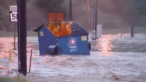
I love that gif
-
1
-
-
Wave 2 bringing the goods
-
I can’t wait to see what a lull in a lull looks like
-
2
-
6
-

February 13, 2021 Ice Storm Obs
in Mid Atlantic
Posted
I knew we'd get our millimeter