

Yeoman
-
Posts
3,179 -
Joined
Content Type
Profiles
Blogs
Forums
American Weather
Media Demo
Store
Gallery
Posts posted by Yeoman
-
-
It kicked every other model's ass back with our only other storm in Dec
-
 2
2
-
-
43 minutes ago, Ji said:
The Canadian tpv is way north of the gfs but the storm isn't much more north. There are other influences
Sent from my SM-G981V using Tapatalk
i think we can safely add TPV to the weenie bingo card
-
4
-
 1
1
-
-
43 minutes ago, mappy said:
Maybe, but I mentioned it because WXUSAF lives in that area, and I thought he’d like to know.
I'd wait for Al Roker's take before drawing conclusions
-
4
-
-
Just now, nw baltimore wx said:
If the para is becoming the new gfs in a month, I am putting my stock in it.

Unless it doesn't show what you want, of course
-
In 15 years of living in the city I can't recall ever seeing ice accretion due to freezing rain.. I look forward to this event!
-
1
-
 1
1
-
-
2 minutes ago, osfan24 said:
Maybe I'm missing something, but this is barely even double digits, if that, for most. Would not call it a crush job. It needs to stay tucked more NW so it snows much longer. Duration is just too short. It's trying to get there, though.
Anything over an inch is a crush job when you've tallied .6" over nearly 2 winters
-
1
-
 1
1
-
 1
1
-
-
1 hour ago, jaydreb said:
It’s not great but if you blend the guidance from GFS, GEFS, CMC, GEPS, and EPS, we’re still in the game for something.

I sure hope that's liquid equivalent
-
1
-
3
-
-
2 hours ago, frd said:
Exceptionally good look considering 276 hours out. All aboard !
Maybe 12 days out will do better than 10
-
Time to play "the models under-do CAD" card?
Next run will show rain in Chicago
-
1 hour ago, Snowchaser said:
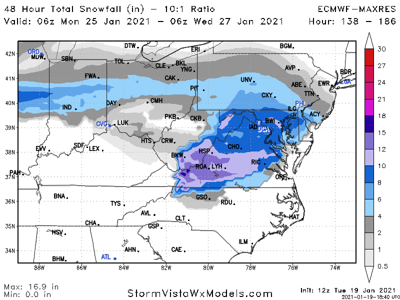
DT posted this snowfall map late last night for the storm early next week. Seems like he is thinking the heaviest stuff might be in SW Virginia.

Looks like 2018
-
3
-
-
Snow block continues to impress!
-
If you want snow go to Hawaii
"URGENT - WINTER WEATHER MESSAGE
National Weather Service Honolulu HI
338 AM HST Tue Jan 19 2021
...WINTER WEATHER ADVISORY UNTIL 6 PM THIS EVENING FOR THE BIG
ISLAND SUMMITS...
.An upper level disturbance will keep clouds and snow showers in
the forecast for the Big Island summits of Maunakea and Maunaloa
through the day.
-
1
-
-
1 minute ago, leesburg 04 said:
Thanks Dave so yes...do you have the other Canadien?
The one that requires a stereoscope to decipher
-
2
-
-
Just now, leesburg 04 said:
Doesn't that look like the Canadian?
The Canadien
-
9 minutes ago, Ji said:
here is a hopeful sigh...first wave washed out 2nd wave--takes southern route

Congrats Chicago!
-
5 minutes ago, Prestige Worldwide said:
BAMWX- not buying the cold
Bam Margera?
-
31 minutes ago, frd said:
Pretty

Another late Jan climo map for 15 days - valid for any given year
-
3
-
3
-
-
10 minutes ago, stormtracker said:
Unfortunately not. Looks like the primary makes it into South MI
Not bad for the strongest blocking known to man
-
2
-
-
9 minutes ago, WinterWxLuvr said:
I’m gonna hang my hat on the fact that the pattern looks good. Mainly because that’s the only think I can hang it on.
The block is working wonders on blocking snow and cold.. thats about it
-
2
-
1
-
4
-
-
5 minutes ago, stormtracker said:
exasperating. I'm gonna hand in there tho, but it looks like the threat late week is starting to fall apart.
Just think - we only needed it to hold together for another 60 runs
-
2
-
1
-
-
9 minutes ago, nj2va said:
LFG.
The 28th storm is looking good so far. Nice H pressing down from Canada. Solid confluence. Big area of precip over TX blossoming.
Oof, looks like it'll be OTS..
I'm liking the Valentines day storm - better confluence and more amped
-
2
-
-
2 hours ago, IronTy said:
My weatherbug app is showing a snow threat next Thurs/Fri. It's been more accurate than any of the actual models so there's that...
I wouldn't count my chickens until we hear what Sue Palka has to say
-
1
-
-
4 hours ago, psuhoffman said:
This is the Eps 72 hour mean day 12-15.
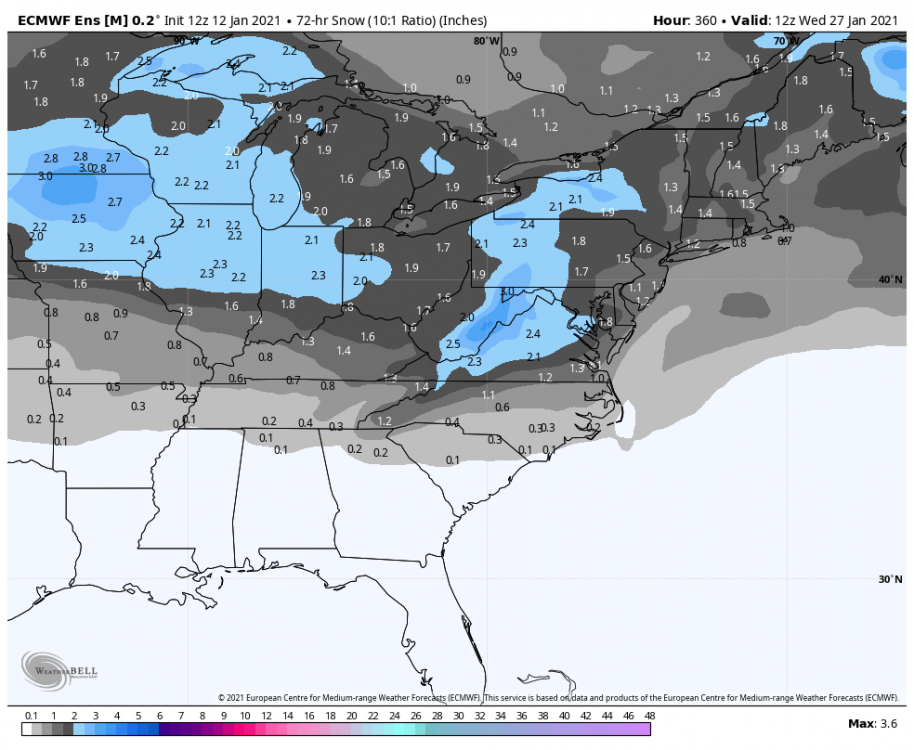
Honestly you won’t see a stronger signal at that range. Both GEFS and EPS are sniffing something there. It’s been on the GFS op also
If day 5 maps can’t get it right, day 15 is def the way to go
-
2
-
7
-
-
1 hour ago, stormtracker said:
Man, this is probably about the lowest morale has been around here in a while....and in the midst of a "great" pattern too. Dark days in the land. I think we should all just grit our teeth and wait one more week from now and see where we are before we hit the cliff.
or at least 10 days


Jan 25th Wintry Mix Obs and Nowcasting
in Mid Atlantic
Posted
Why run the model if it's known to be flawed?