

high risk
-
Posts
3,240 -
Joined
-
Last visited
Content Type
Profiles
Blogs
Forums
American Weather
Media Demo
Store
Gallery
Everything posted by high risk
-
check out the severe thread. The front is probably going through in the early afternoon, and there is some severe potential (mitigated somewhat by limited instability), but some guidance has the frontal passage in the late morning which would really limit the threat. Regardless, as you note, regardless of the timing of the front, the winds are going to howl behind it.
-

2021 Mid-Atlantic Severe Weather - General Discussion
high risk replied to Kmlwx's topic in Mid Atlantic
SPC did give us the day 3 MRGL, and the 06z NAM nest shows the idea of the scenario described above with a strong line of convection moving through the area (not an event for the western folks) early Wednesday afternoon. -
2021 Mid-Atlantic Severe Weather - General Discussion
high risk replied to Kmlwx's topic in Mid Atlantic
It's not a pipe dream; I'll say that. It looks like there will be a line of forced convection just ahead of the front early Wednesday afternoon in an environment with fairly decent speed shear. It should warm up to the mid to upper 60s ahead of the front, but dew points will struggle to reach the low 50s. Forecast soundings have only a small amount of CAPE, but they show a strong inverted-V structure, suggesting some possibility of stronger wind gusts. It's possible that SPC puts us in a day 3 MRGL, although I don't think it's anything close to a given. -
It's not awful, but it's overall not going to be a particularly nice stretch of weather ahead, with lots of clouds and below average temps. Not to bash LWX too much, but their forecasts haven't really conveyed this very well in their products.....
-
FWIW, the GFS is showing that we don't get above 60 throughout the DC metro area on 5 of the next 6 days, but it could very well be overdoing clouds, and it will be way too cold with its temps if we end up with more sunshine.
-
2021 Mid-Atlantic Severe Weather - General Discussion
high risk replied to Kmlwx's topic in Mid Atlantic
Yeah, that was some impressive mixing, but the dews rebounded a bit right ahead of the storms. I was thrilled to get a a nice storm here. -
Unfortunately, the trends for the week ahead are not good. There is growing agreement that a coastal low will form, and while it probably won't be a washout for the Mid-Atlantic, it certainly (barring a flip back to not emphasizing that feature) seems like we are headed for several days in the 50s in the mid to later week period.
-
2021 Mid-Atlantic Severe Weather - General Discussion
high risk replied to Kmlwx's topic in Mid Atlantic
I think they spelled out the competing factors quite nicely. We want heating today, but too much heating is going to mix out the low-level moisture. There is probably a combination of balance somewhere in there, and most guidance is showing at least a few widely scattered stronger cells later today. I'm going to be watching the dew points closely. I don't buy the low 50s shown by the HiResW ARW (which shows basically no storms), so if we stay stay in the mid 50s, I think we can crank out a few cells. Anything above that probably increases the coverage (like the NAM Nest shows). -
2021 Mid-Atlantic Severe Weather - General Discussion
high risk replied to Kmlwx's topic in Mid Atlantic
Good point, although the lack of storms in the ARW is due to it dropping our dew points tomorrow afternoon into the 40s which has seemed really implausible to me. Regardless of the magnitude, it certainly seems now like dew points will drop during peak heating tomorrow. -
2021 Mid-Atlantic Severe Weather - General Discussion
high risk replied to Kmlwx's topic in Mid Atlantic
My call (as well as LWX's high PoPs) is in big danger now of busting. Pretty much all of the 00z CAMs now really mix out the moisture Sunday afternoon, and as a result, it's pretty tough to find more than very isolated showers/storms in any of the simulated reflectivity forecasts. -
2021 Mid-Atlantic Severe Weather - General Discussion
high risk replied to Kmlwx's topic in Mid Atlantic
I think it makes sense. Still come questions about how much heating will occur and whether some of the low-level moisture will get mixed out, but the solutions with the warmer and more moist PBLs certainly suggest scattered strong storms during the afternoon. -
2021 Mid-Atlantic Severe Weather - General Discussion
high risk replied to Kmlwx's topic in Mid Atlantic
It's possible, but the threat would be after dark this evening, and most sfc-based instability should be gone by then. -
2021 Mid-Atlantic Severe Weather - General Discussion
high risk replied to Kmlwx's topic in Mid Atlantic
That was a nice start to the convective season this afternoon. As for Sunday, my guess is that we wake up in the morning to a Day 2 MRGL. Seems quite likely that there will be some storms around later in the day (especially north of DC), and parameters aren't great, there is probably just enough low-level and deep-layer shear to get some decent wind gusts and hail. This will become a more robust threat if the higher NAM dew points (low 60s) are attained. -
c'mon over to the April obs thread.
-
moderate graupel shower here in southern Howard County
-
I actually wouldn't totally rule out snowflakes in some of the heaviest cores.
-
The freezing levels are really low, so I'm pretty sure that any heavier cores like that would put down some hail or graupel here in the metro areas.
-
One potential bit of sneakiness for tomorrow: while most guidance seems to have backed off on the chances of the early morning precip ending as a period of wet snow (although it still seems like a few mangled flakes are possible north and northwest of DC), they are more bullish on the idea of some showers in the afternoon as the upper trough axis swings through, especially on the west side of DC. If you squint at the P-type maps, you can see a little blue in the heavier cores, and the forecast soundings have very low freezing levels and a little bit of instability. I would not be surprised to see some heavier graupel (or even briefly wet snow) showers around.
-
maybe 50s Saturday and near 70 Sunday? 850 temps still look pretty low on Saturday......
-
2021 Mid-Atlantic Severe Weather - General Discussion
high risk replied to Kmlwx's topic in Mid Atlantic
500 j/kg of CAPE will do that.... -
2021 Mid-Atlantic Severe Weather - General Discussion
high risk replied to Kmlwx's topic in Mid Atlantic
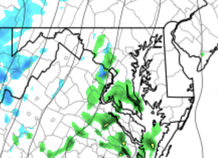
Back in town now, and while this is nowhere as good of a setup as it looked like it might be a couple of days ago, it's not dead. The instability is of course the big question, but with strong forcing on the front and pretty good shear, there will likely be a line of convection ahead of the front. (It is clearly getting organized now). If we get up near 70 over the next few hours, there is probably some wind damage potential. The better chances are certainly further south, but I'm not totally writing it off north of town. -
2021 Mid-Atlantic Severe Weather - General Discussion
high risk replied to Kmlwx's topic in Mid Atlantic
I fully agree. The shear on all guidance is incredibly impressive - I'm even seeing big, looping hodographs and PDS TOR on some forecast soundings. Still some questions about instability: the parent NAM by far looks the best. GFS keeps showers and clouds around for much of the day, limiting heating. NAM nest seems to mix out the low level moisture a bit during the afternoon, although even that model has an impressive QLCS approaching late in the day. -
2021 Mid-Atlantic Severe Weather - General Discussion
high risk replied to Kmlwx's topic in Mid Atlantic
I'm totally out on this one. Honestly, I'm not sure that discussion makes sense unless they're talking about the very southern part of the CWA. We do not get anything close to SVR here from elevated storms above a stable boundary layer. I'll consider it a big win if I hear thunder Thursday evening. -
It's my day!!! I'm humbled, but I can't help but think that a high-end MDT would have worked fine for today..... In other news, this may have been covered elsewhere, but the NCEP "critical weather day" means that GFSv16 can't be implemented today (or tomorrow with the MDT). As a result, it has to wait until next Monday.
-
We’re getting close, but implementation is actually on Wednesday morning.


