high risk
-
Posts
3,107 -
Joined
-
Last visited
Content Type
Profiles
Blogs
Forums
American Weather
Media Demo
Store
Gallery
Everything posted by high risk
-
I think that what is happening is that the MAG site where you got this image displays "snow depth change" and not "positive snow depth change" like Tropical Tidbits does. The distinction is that the snow depth change is going to tally snow on the ground today that melts before Thursday night as a negative. So, if an area has 4" melt and then gets 4" of new snow, that map will show a 0. (Even negative values are possible, but that map starts at 0.) The positive snow depth map on Tropical Tidbits looks way different and shows several inches of new snow across VA/MD/DE.
-
Sneaky freezing drizzle potential early Wednesday? Several CAMs show some spotty light precip early Wednesday generally on the east side of the Potomac. Some of it is shown as rain, but some of it is freezing rain. Air temperatures are progged to be right around freezing, but the surface temperatures will likely be colder than that.
-
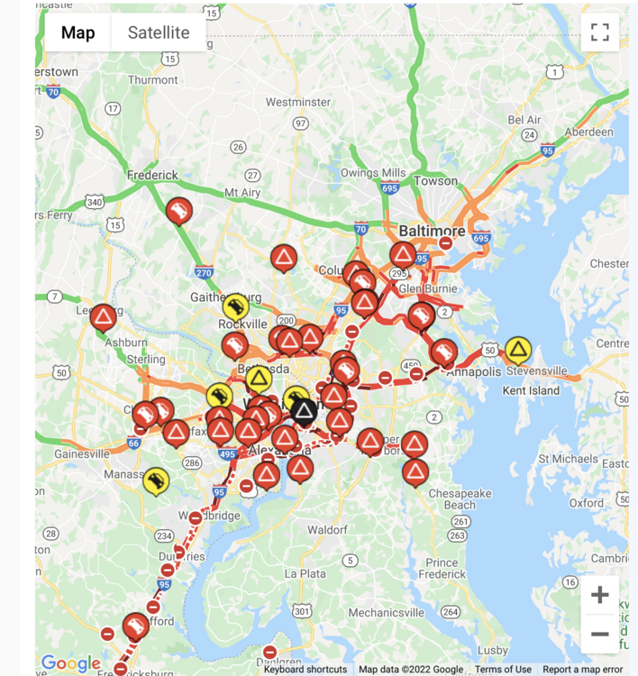
I-95 in central Virginia still a complete mess. People stuck in their cars for many hours and running out of gas now.
-
Superstorm '22 is a lock. Got it!
-
5.8" in southern Howard County. Feeling fortunate to have stayed just south of the northwestern edge of the snow for several hours.
-
This traffic map does an incredible job showing which areas have been crushed and where the northern edge of the snow has resided.
-
Will be retired. NAM (parent and nest), RAP/HRRR, and Hi-Res Windows will be turned off when the RRFS is implemented (or very soon after).
-
Sort of. Yes, the NAM (and RAP/HRRR and Hi-Res Windows) will be subsumed by a hi-res, hourly FV3 ensemble (called the RRFS), but the configuration of that hi-res FV3 is not what the configuration of the RRFS members will be (different physics, different initialization....). Think of this run that you showed as sort of a hi-res GFS for now.
-
My standard word of caution that the 10:1 maps should not be used verbatim in many events, but especially in one with warm ground and marginal temps (at least at the start). We're not going to see 10:1 for most of the event, and while I am a believer in rates overcoming warm ground (especially when it's not the middle of the day), some accumulation could initially be lost. The accumulated snow depth maps tend to cut amounts a bit too much in these scenarios, but a compromise between the 10:1 and snow depth maps can work.
-
I'm rooting hard for this, not just because I want snow, but also because it will be even more difficult to retire the NAM if it scores a huge win on this event.
-
great sunset pics! it was definitely a pretty evening:

- 291 replies
-
- 10
-

-

2021 Mid-Atlantic Severe Weather - General Discussion
high risk replied to Kmlwx's topic in Mid Atlantic
There is definitely some sneaky wind potential Saturday with a forced line of convection on the front later in the day. I'm tossing the NAM Nest solution which has the line fall apart - it tends to run cool, and I'm not buying its idea that we only get into the low 60s Saturday with the temp dropping as the sun sets. I think we have a good shot to hit 70 and get a dew point up around 60, and it will stay warm until the line arrives. With really strong winds just above the ground, it won't take much to mix down that momentum - that said, we won't have "much". Even at 70/60, instability will be really limited due to warm mid-level temperatures. So I think that we'll get a gusty line of showers, but it seems like little chance of lightning and a low chance of gusts close to SVR. The strongest winds might be later in the evening right behind the front. -
Even if we got a dusting, which seems unlikely now, the need for pre-treatment is really, really questionable. You'd have light snow falling during the daylight hours with marginal air temperatures and road temperatures clearly well above freezing.
-
We already do, for the RAP/HRRR.
-
You're correct that it's a mesoscale version of the GFS (it's not as simple as just saying it's the GFS run at 3 km). The FV3 is now one of the Hi-Res Windows, along with the ARW and ARW2. (The FV3 replaced the NMMB in the last HiResWindow upgrade.) All 3 of those models, along with the NAM Nest and HRRR, make up the HREF. The hi-res version of the FV3 is an initial step towards replacing all of the hi-res models (the Hi-Res Windows, HRRR, NAM Nest, and the HREF products) with an hourly, high-res FV3 ensemble in a few years.
- 359 replies
-
- 11
-

-
-
70! It's glorious.
-
At least with the clock change this weekend, we can now get screwed by the guidance an hour earlier.
-
1.61" at BWI in the past 3 hours. Over 2" for the event.
-
The models have been indicating that some scattered convection would develop in the dry slot, where some weak instability would develop. Fortunately, the good low-level shear is rapidly moving away to the northeast.
-
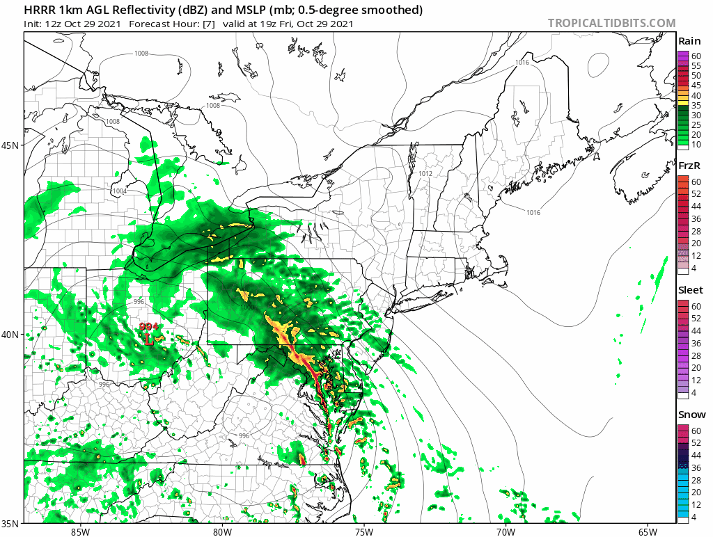
There is a large area of heavy rain with convective elements now affecting the areas just east of DC moving north into Howard Co and the Baltimore area, with more redevelopment further south. I'm not saying that it's going to be a widespread 4-5" event or anything like that, but the totals are really going to add up over the next few hours.
-
But the heaviest convective elements have yet to move through the areas on the east side of the Potomac, and the HRRR (and other CAMs) have been suggesting redevelopment which will keep the rain going for a while, and the latest HRRR runs suggest another 1-2 inches for some. Accordingly, WPC is discussing potential flash flooding in the 2-5pm time frame: https://www.wpc.ncep.noaa.gov/metwatch/metwatch_mpd_multi.php?md=1115&yr=2021
-
The big question is whether the line of forced convection that races northeast through the area this afternoon can mix down the stronger winds just above the surface. It may be too stable to do that (especially on the north side of town), and the best low-level winds will be exiting to the northeast as the line arrives, but if we can overlap just a little bit of instability with the stronger wind fields, it could get really ugly.

-
2021 Mid-Atlantic Severe Weather - General Discussion
high risk replied to Kmlwx's topic in Mid Atlantic
In addition to the coastal flood threat, areas generally south of DC are in a MRGL risk for damaging convective wind gusts Friday afternoon. Several models are now showing a little bit of sfc-based instability Friday afternoon, which could allow some of the faster wind speeds just above the surface to mix down. I'll note that 1) a few CAMs develop instability even further to the north than currently indicated in the MRGL region implying a more widespread threat but 2) a lot of the stronger wind speeds above the surface will move off to the northeast before the instability develops which implies an overall lesser threat -
2021 Mid-Atlantic Severe Weather - General Discussion
high risk replied to Kmlwx's topic in Mid Atlantic
Good point, and the HRRR is still struggling to initialize them. The only guidance that explicitly showed this was the ARW2. Some of the other guidance has shown cells developing later this afternoon south of DC and moving north, so I think that these solutions correctly captured the northward-moving forcing mechanism but struggled to initiate storms much earlier and much further south. -
2021 Mid-Atlantic Severe Weather - General Discussion
high risk replied to Kmlwx's topic in Mid Atlantic
Dew points have been lowering at all 3 airports over the past few hours (likely due to mixing), which seems to match what the HRRR has been forecasting.