jbenedet
-
Posts
7,684 -
Joined
-
Last visited
Content Type
Profiles
Blogs
Forums
American Weather
Media Demo
Store
Gallery
Everything posted by jbenedet
-
 euro at 24 looks more amped vs 6z. West.
 -
And zoom out to the scorecard for winter - even worse. Most will probably gloss right over this, but that link is the most important post this morning. Had no idea the GFS was having such a poor winter season. Euro clear leader. Definitely instructive, especially while the pattern has been largely consistent over most of that time series.
-
Good points. I like a balanced discussion. As I watch the 12z NAM roll to hr 42 and also look at that trend Gif I posted of the GFS—look at that pacific ridge axis-now as far west as Vancouver at that hr. Never say never, but this is NOT a long-wave spacing/setup for down east ME and Nova Scotia, to take the brunt. To my mind the betting risk is highly asymmetric in favor of west of current guidance.
-
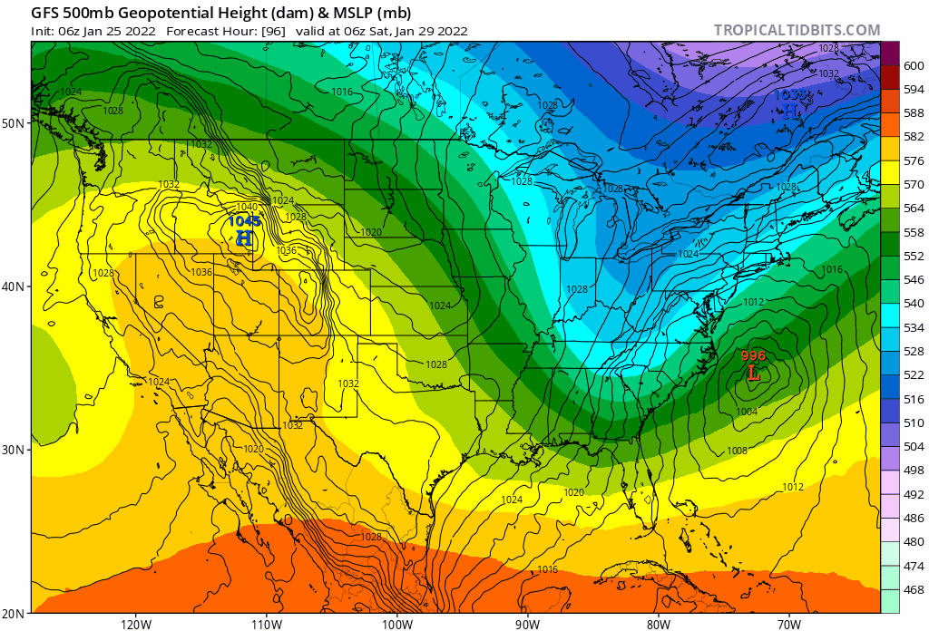
Most are looking at the surface off the east coast, but the trend at H5 on the GFS is fantastic, with the trough orientation trending negative, sooner and better alignment/phasing between northern and southern streams. I say keep this trend going and worry much less about UL heights off the east coast in a situation such as this where there is no blocking. Guidance notoriously under-amplifies UL heights downstream of a potent shortwave. I’ll take that risk any day over UL trough orientation/position. The latter is much more important at this stage.
-
Sure? I mean, to me I think the risk is Friday impacts to school and evening commute are much greater than consensus right now.
-
NAM (of all models) has snow starting for most by Friday p.m. Western Areas early afternoon. Tucked = earlier. tick tick
-
You can buy, I'll sell. If it happens to be right that will increase uncertainty "chaos" with regard to the H500 capture. We won't know until inside 24 hrs, nevermind 96. to me the surface reflection is ~100 miles west at that hour, and there is no warm occlusion/core.
-
Wonky look. Warm core? As much as I like this solution, this doesn't make meteorological sense in January.
-
I'm guessing that sea eagle will be leaving it's new pad in boothbay Hahbah. Kinda pissed I missed the chance to head up there.
-
Yea, high amplitude long wave pattern, but very fast flow. +NAO, +AO. We have seen this time and time again translate to a much earlier/faster start time, 12 hrs+ at these lead times.
-
Yea and it would come in much faster. 12 hrs+. Would be a Friday/Saturday impact, rather than Sat/Sunday
-
The western Ridge keeps trending further west with time on guidance at around hr 72. An axis over western Washington state without any blocking in eastern Canada is typically a recipe for a cutter or very tucked in track. If the northern stream and southern stream cleanly phase early—around hr 72, this comes much further west than current guidance consensus—there’s plenty of “room” in terms of wave spacing.
-
Rain, snow, blizzard whatever if this happens on Saturday ice festival at lake Winne I’m going to be pissed. Hoping this becomes a Friday event.
-
Arctic cold and new threat emerges for the 26th. Patience Grasshoppers.
jbenedet replied to Ginx snewx's topic in New England
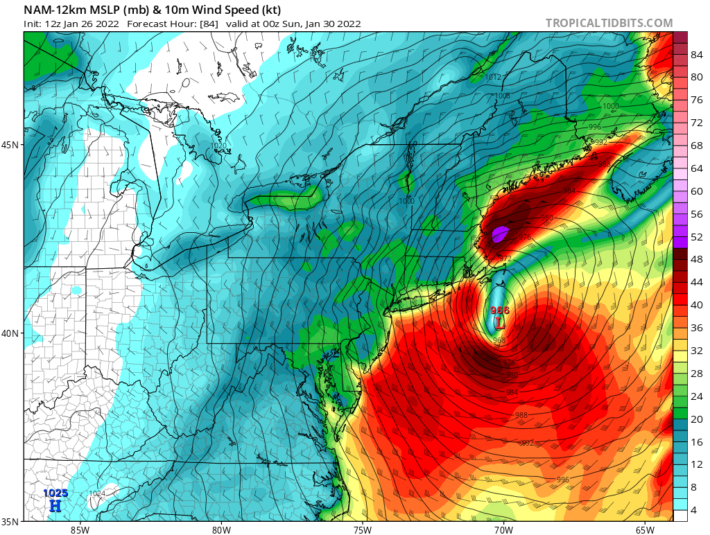
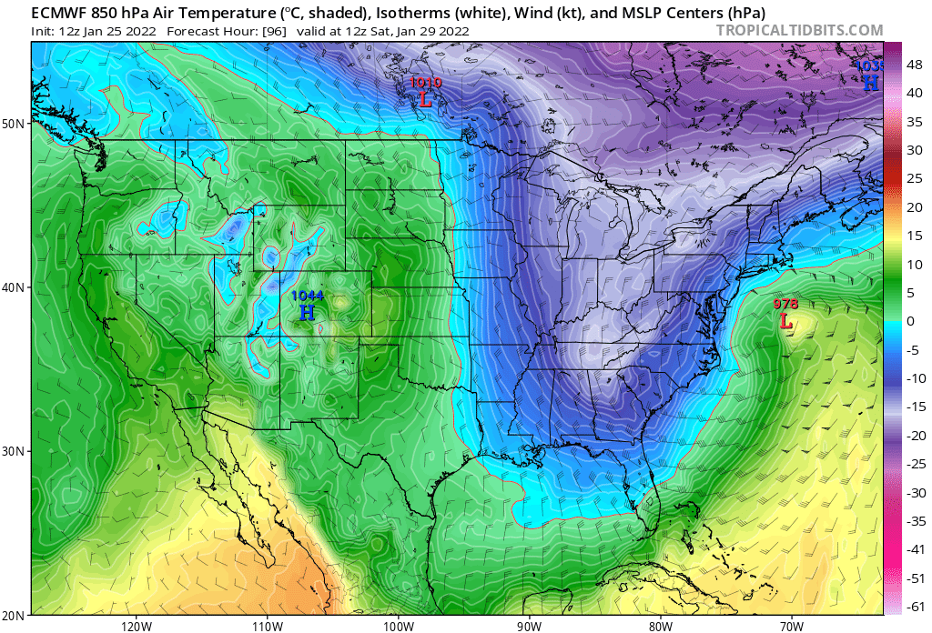
The timing of the southern stream shortwave has worsened significantly over time. Northern stream relative to southern stream keeps speeding up. Makes sense with the AO + and increasing… This has evolved into a clipper with a redevelopment/enhancement near the Gulf of Maine. We know how these work—the earlier/further south the coastal gets going the better. Having the coastal predominate south of the Cape than east of PSM would be a big deal in terms of regional impact. Unlikely, but still good enough odds to monitor. Right now northeast MA to coastal ME is best chances for more than a few inches. -
The southern stream won’t just fizzle like that. That’s a potent shortwave. It’s not running into confluence. Fast flow, but not confluence.
-
In evolution, Tuesday reminds me a lot of Jan 7th. and to a lesser extent the prior storm that hit the mid atlantic. It's the same tenor, really. A northern version of Jan 7th
-
Didn't realize. You're right. I think it will be more of a Tuesday (25th) event, but whatever, that's the threat. Thanks!
-
Open a thread for Tuesday. It's all we got.
-
I like the Tuesday threat. Close enough to evaluate (with seriousness) what current guidance is spitting out - the location and intensity of that H5 shortwave in the southern stream on the GFS looks like a classic case of GFS having to amp that up (along with downstream UL heights) as we move in. I think we see this trend towards southern stream predominant, and less amplification of the northern stream as currently advertised. Terms of scale - I think a a very broad 4-8" (local 5-10") type event if it evolves as I think it will. If everything aligns, I think it's capped at low end SECS potential.
-
ACY 39/33 on a southwest wind. Down from 43. She’s cut-off. Very cut-off. The CAD is moving in fast. Back to freezing by early afternoon?
-
Been raining for an hour here, but appears DAW still snow. 10 miles will once again mean all the difference.
-
Monitoring a potential important TV to East Coastal storm: Jan 17
jbenedet replied to Typhoon Tip's topic in New England
That’s a valid point—but won’t be until after midnight…. -
Monitoring a potential important TV to East Coastal storm: Jan 17
jbenedet replied to Typhoon Tip's topic in New England
Stronger storm. seeing a bunch of meso lows south of LI across guidance. As usual, will be interesting to see how much this slows the easterly fetch and quick torch. -
Monitoring a potential important TV to East Coastal storm: Jan 17
jbenedet replied to Typhoon Tip's topic in New England
It’s Jan 16. The sun sets in 3.5 hours. Temp peaks around 2 p.m. this time of year. 21 high is my bet. dew dropped from -6 to -7.