jbenedet
-
Posts
7,683 -
Joined
-
Last visited
Content Type
Profiles
Blogs
Forums
American Weather
Media Demo
Store
Gallery
Everything posted by jbenedet
-
DAW 6 day stretch. 95, 95, 95, 93, 96, 99
-
You live close enough. Go take a drive and a reliable thermometer. We are cooked.
-
I counted 6 days out of 23 for DAW, 4 out of 23 for SFM. Far from most. Bulk of which coincided with the heatwave. And isn’t that exactly what you’d expect in a +3SD airmass? I think there’s an enhanced ageo flow due to mesoscale coastal front, max surface delta t/delta n, sets up regularly right along NH coast, where the Labrador current meets a cooked tropical airmass.
-
Quite the seasonal extremes here. It’s like flip extreme CAD tendencies in February from DAW to EWR, and call it WAD in July, and instead of the airmass advecting down the Apps from DAW to EWR it’s up the Apps from EWR to DAW. You can see even global guidance picks this up regularly with the mesoscale WAD 75 miles into York County Maine.
-
Most of SE NH is in severe drought conditions now. Barring low chance of widespread heavy thunderstorms, Monday night, this will be reflected on next CPC update.
-
This is the hottest stretch in memory since I moved here June 2015.
-
Rochester New Hampshire past 5 days, with dews 60+ throughout. 95, 95, 95, 93, 96, And today will be the hottest.
-

Severe Weather Threat Week...so many threats!!!
jbenedet replied to weatherwiz's topic in New England
Ooof. That's a plant flattener at the peak of the season. Cool to experience but a hard pass, especially in late July. Whatever gardeners/farmers were in the way of this are now looking to next season. I'll gladly take my drought. -
In spring to early summer maybe. But fall and winter seems among the fastest. Averaging it, over course of a year we are among the fastest. What’s really interesting is we are at the tail of a cold water current, from the Arctic, whereas the UK is at the tail of a warm water tropical current. The UK has been seeing significantly warmer summers (++AN) but cold winters (N to AN); we have been seeing significantly warmer fall and winters (++AN) with warm summers (N to AN). The causality (net increase) is quite similar, but the seasonality is flipped. There may be a cogent physical explanation for this…
-
The Gulf Stream must be cooking. You'd think coastal fronts would have capped temps all over the UK long before they got near those temps. The UK is ground zero for greatest rate of climate change - High latitude + surrounded by water + Gulf Stream.
-
Agree for sensible weather, but it's a terrible trade-off for the vegetable gardens. As I've increasingly taken up gardening my likening to weather has shifted to "what's best for the plants".
-
Warm front showers and then....? Meh... If we could lose the clouds after the warm front it would be game on, but I'm very skeptical of that, especially in SE NH. Southerly fetch also gets tainted by marine layer in eastern areas. I like central western MA and central/western CT for severe chances--warm front clears early and looks like good chance sky clears to destabilize things.
-
Rain water is also so much better for the soil than treated water. I avoid using the latter in the garden, entirely.
-
Good drink. First day in a long time won’t have to water the garden. Filled up my rain barrel and buckets. Enough for 18 days without another drop of rain for the fruit and vegetables. Droughts are not an issue if you have any kind of rain water collection system from gutter run-off. It obviously varies by square footage of roof but 0.1” of rain is approx 10 gallons rain water in your tank. That’s all I need for 35 plants - 0.1” rain/week on average.
-
Yea it’s been very dry here too. Rain barrel getting light. Good news is the drought withers the tree leaves shading my vegetable garden, which gives them an extra 1-2 hr additional sunlight. I need direct sunlight more than the rain. Another 2 weeks of this and that will change though.
-
90% of winter: +NAO 2/3 spring: -NAO
-
Anyone ever see a brown recluse in the region? Something very similar? Could have sworn I saw one the other night on my back door. Almost shit my pants. No web. Just hanging out on the lower portion of the door. Should have snapped a pic. I usually leave spiders that are outdoors as a means to kill all the other pests. But this one had me thinking it’s an exception. Warm basements due to oil furnaces can make for microclimates…
-
That’s what I’m noticing. My tomatoes and peppers exploded in June. I believe late May was also much warmer. Granted it came with a lot more watering. I feel like they’re 60% - 75% growth of last year ytd.
-
I know I’m slightly warmer than you but that helps explain why my vegetables are all behind vs previous few years despite the copious rainfall. I should start taking soil temps. Doesn’t help that the vegetables I like, and already planted outside all prefer the warmest conditions—tomatoes, squash, cucumber, peppers, and I have eggplant starting inside.
-
This is gonna be pretty cool. I believe this gets pushed forward ~24 hrs to Monday given the guidance trends.

-
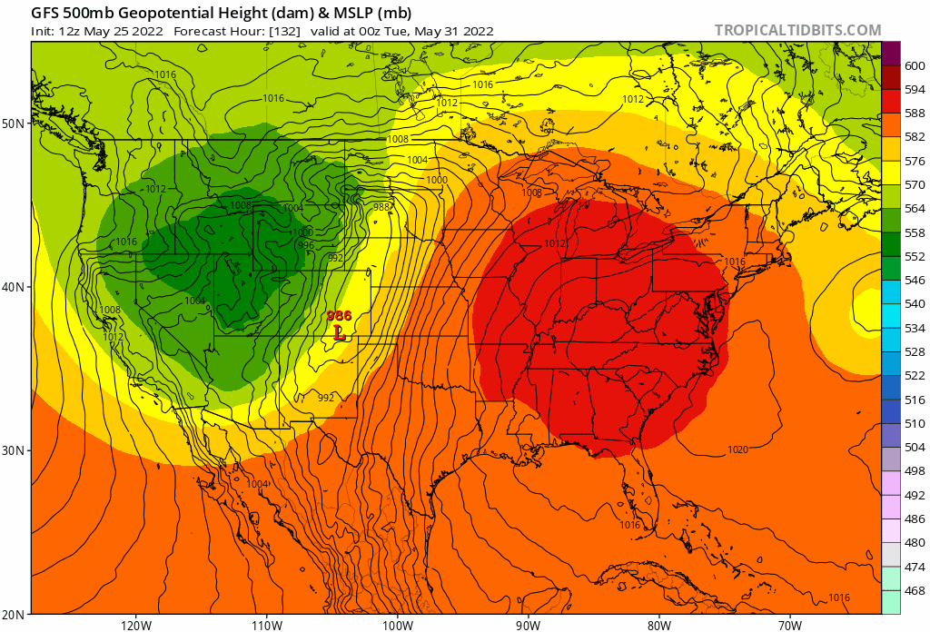
Can have a beautiful mid spring weekend on a Canadian airmass in late May. At this point, after looking at the tele’s, hoping the block flexes to send the door down to the mid Atlantic. We avoid the rain, and have dry mid 70’s. Not summer, but great for BBQ’s, hiking and camping. Best chances for a nice weekend with this setup are further north and east into NNE. Pretty damn remarkable timing. I mean, it’s probabilistically rare to muck up a 4-day window this time of the year. But here we are. Again.
-
We’re going to bake this weekend. Even the EPS is showing 90 in SE NH already.
-
Many shades of Persistence. Really hope we shake the dry and hot pattern come June though. Scorched with the high sun angle. It’s brutal for the young plants. Had several casualties last year.
-
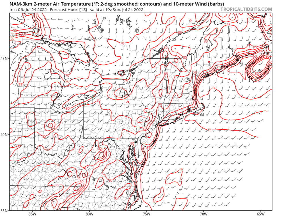
Coastal SNE is surprisingly chipper given the latest guidance. The seabreeze front going to push well inland everyday through Friday looks like with strong surface HP hanging out over the GOM. 50's more likely than 70+. OOf.
-
This is the first year I’ve grown full vegetable plants indoors prior to planting. Should have started earlier, but coming along nicely now. Fortunately I get plenty of natural light. Would suck if I had to rely on a grow light. With 1st half springs like this, this is the way. Miserable otherwise. Even if you miss the late frosts/freezes these persistent marginal air masses cause everything to grow at a glacial pace. Not worth early planting. Period.