

jbenedet
-
Posts
7,682 -
Joined
-
Last visited
Content Type
Profiles
Blogs
Forums
American Weather
Media Demo
Store
Gallery
Everything posted by jbenedet
-
The H5 cut-off low is filling with Pacific air thanks to the raging PAC Jet. One reason why the solution seems so non-sensical, and why it looks like a warm occlusion.
-
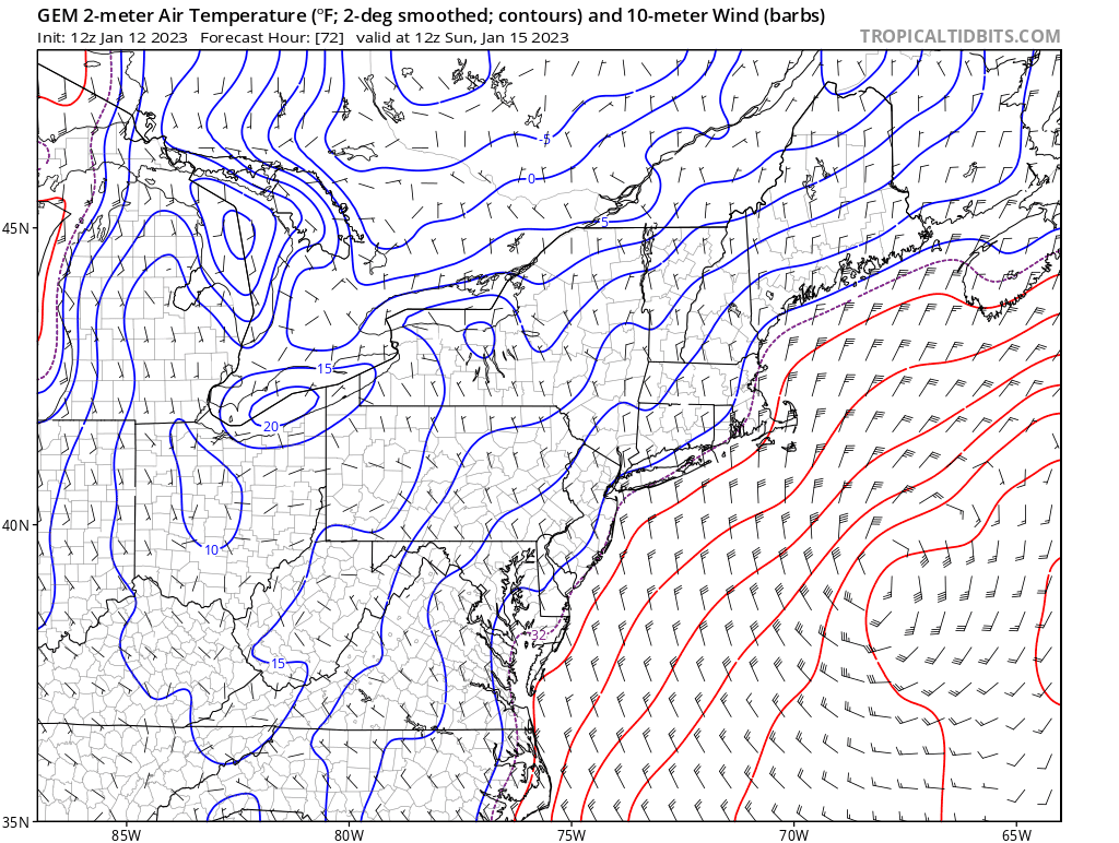
59 in Philly already. zero chance anyone in new England hits 60 tomorrow says @Ginx snewx Guy is a seer. Calling blizzards and all. What a guy.
-
The geese shat all over your pattern change. Modelologist.
-
"Hate has no home here" is your profile pic. In an american weather forum. Snowflake? Maybe some relevance there. Check yourself bro. Embarrassing.
-
For the math challenged. Prob </= 60 anywhere in New England tomorrow = verification. Yes that is still possible. Cheers
-
Use the quote function or improve reading comprehension. Thanks
-
So many snow obs, so little to show for it. That really has been the story this season. Been snowing since 6 a.m. but poor snow growth. Looks like about an inch. Changeover imminent.
-
I mean precip - how much...who knows? That's the hard part. But from a snow total forecast - BL temps will put a tight lid on this for Cape and Islands at least through Sunday Night. Looking at even the 12z CMC, which is nearly ideal track, ratios will be a significant inhibitor. If the stars align, Sunday night into Monday a.m. could get interesting out there.
-
Friday has gorgeous day potential in Eastern SNE - classic needle-threader in between fronts with cooked 850's and sw flow, timing coinciding with max ISR in early afternoon. Maybe tickle 60 in spots? That would be awesome.
-
I mean - this is forecasting; it's all a game of odds. Committing is a word that should be taken out of the medium to long range forecasting vernacular, unless of course we are committing forecasting suicide. It connotes absolute confidence. We need to do better to accurately convey uncertainty. Maybe it was lost, but I'm broadly painting a picture here that, I believe odds favor big storms in the east, but odds also favor New England is on the warm side of these. If we lock into east based blocking, big snow potential much greater than normal, i.e. vs H5 analogs. That's all. It's your CPC monthly level of detail. It says something if you're looking at it with uncertainty in mind.
-
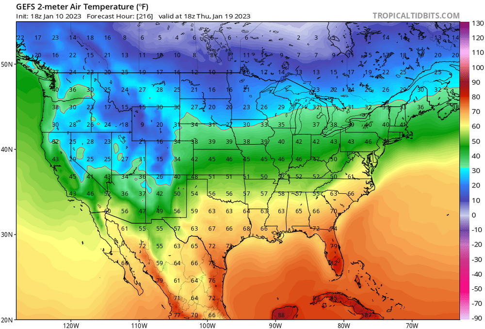
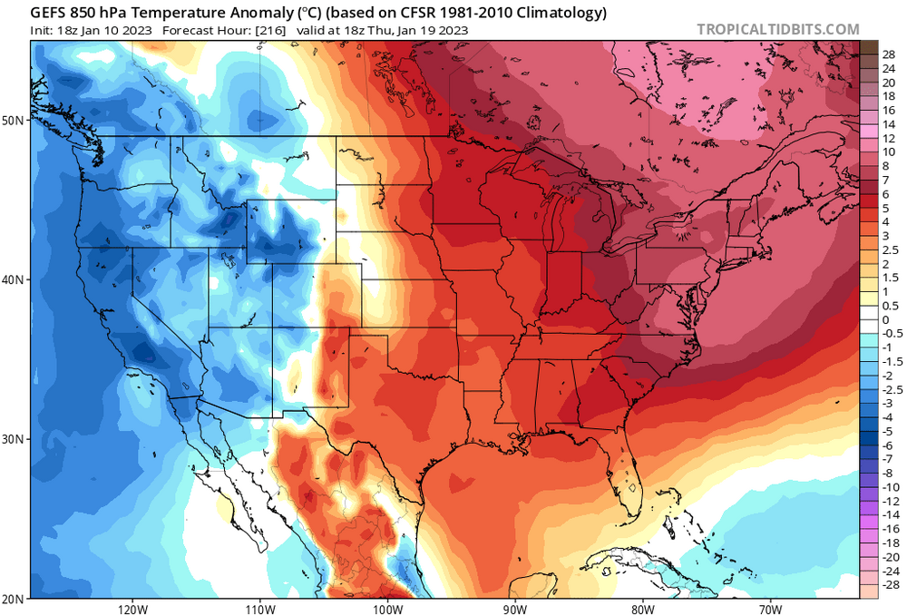
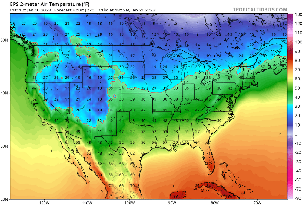
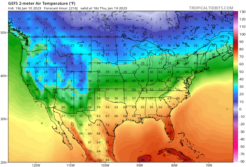
Gonna be really interesting seeing Jan 20th, region wide observationally fitting November 20th. We keep bringing this up but the climo disparity will be most significant at/around that time frame. At the same time, the arctic and cold source regions such as Siberia are following their Jan 20th climo and in some cases have been colder/snowier than climo. Tying this together it makes for explosive baroclinicity in the Eastern CONUS. To elaborate: I believe if/when the arctic is involved we will be prone to seeing rapid cyclogenesis and deepening shortwaves in the East. From a "big storm" standpoint, this is obviously intriguing; but from a pro-cold/snow standpoint - absent high latitude blocking you will really want to see Long wave troughs overhead (moreso than usual). Or probabilistically: warm sectoring risk higher than normal; suppression risk lower than normal.
-
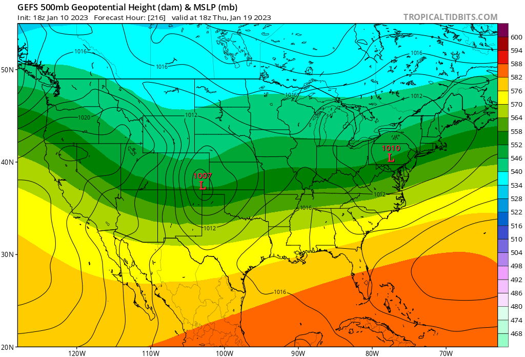
And then the 18z GEFS, for the same storm system— snowing at this hr on the 18z GFS. H5 not so bad….”workable” 850 and below…

-
It’s all kinda backward. Usually mets complain about amateurs not using H5 enough; I think most lately are guilty of not testing those juicy H5 depictions by seeing what the model output is showing at those same hrs @ 850 and below. Red flags.
-
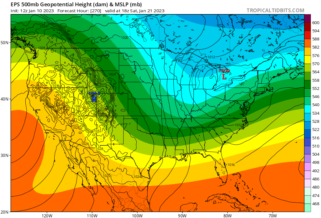
The beatings will continue until morale improves. H5 keeps roping in the long range model junkies with looks like this. Here’s the EPS with a pretty damn similar look to @brooklynwx99GEPS H5 clip. But then you go and look at the surface and it’s cooked. And with no blocking? This is a worse depiction than what we have coming on day 3; it’s just not resolved yet.

-
A -NAO would go a long way
-
Not for nothing but that analog quite literally has the ridge and trough axis about 500 miles further east. BIG difference. And this season isn't one I'd be discounting it. Persistence is a biatch. Assuming it's correct anyway.
-
This trough and ridge axis is actually too far west, by a good 500 miles. Congrats buffalo? For us it's still a risk for cutters, with no blocking when a strong shortwave hooks up with the arctic in the mid-west. Weaker waves will threaten warm sectoring SNE and eastern areas into coastal maine. Good for the far interior. With the background warmth we'll have around this time (vs climo), I'm not a fan of this look for the subforum in general.
-
The consolation prize for this MLK weekend rainer, is planning a trip further north wouldn't have helped much, or at all. Talking Sunday River or Jay Peak to find skiable conditions, and that's too far for most. I believe the North Conway ski mountains will be in rough shape. Even wildcat in Gorham, looks sketch.
-
Makes sense. But right now? Flip a coin. That's what such a high level of run-to-run inconsistency tells me. GEFS/EPS say there's a non-negligible chance of something more. It's also further out in time - day 5. Probably can't toss this aspect until we see consistent runs like that on Thurs. This has been a season of tucked secondaries. Albeit crap ones. I'm on board for both these attributes.
-
A glorified fropa. West cashing in on this makes sense given the way the BL floods with marine air in the east, out to the CT river, and NNE into New Brunswick Canada. Eastern Upstate NY best spot currently, Vt, Berks right behind. And ironically that ocean influenced Surface WAA that skunks us is what largely lays the ground for secondary cyclogensis, with UL height falls right behind it. We don't have a cold press, or surface high anywhere in the northeast by the time this sets up, so I don't see why the SLP can't Bee-Line it to Caribou.
-
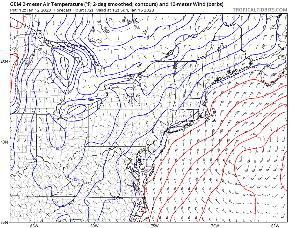
This is a pretty effin' hilarious H5 look, when most are hungry for snow. Late October/early November vibes. I know I know it's one run of the op at hr180. But it isn't exactly la-la land "clown range" time frame either at day 7/8. Maybe we look for records in the other direction?
-
I hate these secondary frontal wave looks - the BL takes a lot more time to cool than the snow maps portray. 37/31 and mod snow doesn't pile up - and temps are warmest when the precip rates are best. And then you have warm, wet ground preceding it. It takes a lot to go right for it deliver something more than the nuisance variety. Vermont and the NH whites may able to cash in, especially with some orographic assist. Elsewhere don't like this look at all. But we'll watch...
-
CON-fluence. That is, you have been conned. Canadian High runs East, surface cold doesn't press, bulk of it stays bottled up in QC and NB. +NAO look.
.thumb.gif.7ec602a1e015f68b4a4fb8aa4f18c4b2.gif)


.gif.0bfc6ed1b64b1a0663cb32d03649f1e2.gif)