jbenedet
-
Posts
7,617 -
Joined
-
Last visited
Content Type
Profiles
Blogs
Forums
American Weather
Media Demo
Store
Gallery
Everything posted by jbenedet
-
Who’s down in Great Bay area?That cell missed me to the south by like 3miles.
-
Man that southern cell when it gets toward coastal plain should be really interesting. No mountain disruptions on the Great Bay….
-
Yea this looks like a good show incoming. buckle up. Been a year for severe. Not expecting a fizzle upon closest approach.
-
The natural disaster risk that has increased the most around here in recent years is fresh water flooding. That’s something worth worrying about… Forget the tornado, worry about the rain that’s coming with the spin-up.
-
On vis satellite the structure of the cell heading for Manchester appears to be improving…Getting those overshoots into the stratosphere.
-
I get what you mean by crisp. Agree on that. We’ll have to see if the structure improves as the they isolate from the inflow/outflow of the competing cells/line further north.
-

Invest 92L in SW Atlantic reached SE US Fri
jbenedet replied to GaWx's topic in Tropical Headquarters
closed LLC is not the limiting factor - it's dry air. We have the low level vorticity to work with, for sure. But we don't classify naked swirls for a reason....So from NHC standpoint - challenge is to see that this thing can maintain convection over the LLC to promote positive feedback and cause minimal TS conditions at the warned areas upon landfall... -
Temperatures that make you wish for rain. A special kind of unbearable out there... This is the worst back to back days of heat I've experienced in my lifetime. Heat Index hit 110 yesterday and it looks like it will do it again today. Just in awe at this point, honestly...
-
It honestly limits your range of activities as much as the worst weather in winter. The dogs are just as unhappy.
-
No. And No. I like summer heat but heat index > 100 is you just want to stay inside or in the pool. Everything else is off limits. Heat index 110 is just brutal. You hunker down inside. Yesterday was first time I felt shortness of breath at times just on short walks and even on the motorcycle. You could absolutely feel the lower oxygen content in the air. None of this is enjoyable.
-
Alright a heat index record. Nice to have the reference when it's the dews tacking on another 15 F in real feel
-
That's not pretty dewy. It's just straight up tropical. Our dews are tracking Miami Florida.
-
Heat index of 99 at DAW as of 9:50 a.m. We started much hotter here today, than yesterday. It's a furnace already. Hotter start. No clouds. Less wind. Ya really can't get hotter around here than these conditions... This is uniquely miserable. I'll try to enjoy it for its "holy shitness"
-
May 2024 Discussion - Welcome to Severe Season!!!!
jbenedet replied to weatherwiz's topic in New England
Not really. It’s May 19. -
May 2024 Discussion - Welcome to Severe Season!!!!
jbenedet replied to weatherwiz's topic in New England
~80% of days since 1st day of spring have been with -NAO. This is flipped from winter. -NAO incoming, again, beginning this weekend - good news is (right now) looks significant enough to send the worst (easterly flow) down to the Mid Atlantic and we can 60-70 in mid May behind the door, with surface HP overhead..... Hedge in favor of dry, seasonable temps and low dews in NNE. You guys in far southern sections--good time for a vacation.... -
May 2024 Discussion - Welcome to Severe Season!!!!
jbenedet replied to weatherwiz's topic in New England
Managed to take the bike out 4 days this week, including today. First time since November. We are passed the shit up here; but it's still only okay by New England standards, which is obviously still a low bar...hah. -
May 2024 Discussion - Welcome to Severe Season!!!!
jbenedet replied to weatherwiz's topic in New England
I'll take low 60's and run with it. -
May 2024 Discussion - Welcome to Severe Season!!!!
jbenedet replied to weatherwiz's topic in New England
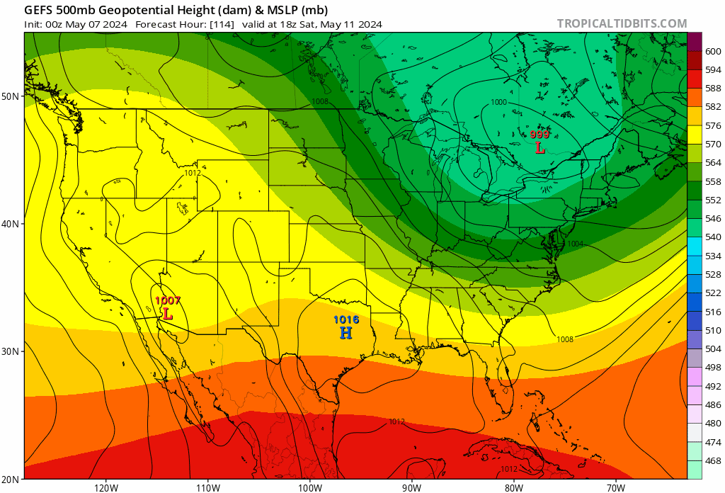
GFS/GEFS is coming around to GEM/EURO view for this weekend, but not without kickin' and screamin'.
-
May 2024 Discussion - Welcome to Severe Season!!!!
jbenedet replied to weatherwiz's topic in New England
Looking at most guidance ex the GFS op you can see how odds favor decent weather. GEM makes most sense to me. Even the 12z GEFS has the surface low SE of the BM by 12z Sat. Not buying bs IVT on the GFS. -
May 2024 Discussion - Welcome to Severe Season!!!!
jbenedet replied to weatherwiz's topic in New England
Next weekend is coming around, to "okay", from dreadful - but man is the crap weather pattern fightin' hard. -
May 2024 Discussion - Welcome to Severe Season!!!!
jbenedet replied to weatherwiz's topic in New England
Pfff. Bug repellent. Do your yard work in the rain. Problem solved. -
May 2024 Discussion - Welcome to Severe Season!!!!
jbenedet replied to weatherwiz's topic in New England
To put some objectivity to our pessimism: this year, most in our subforum will have the landscape in a cold season state fall/winter >6 months; i.e, longer than a warm season spring/summer state. First week of November is only 6 months out….
-
May 2024 Discussion - Welcome to Severe Season!!!!
jbenedet replied to weatherwiz's topic in New England
There’s a switch out of this hellish -NAO regime next week, and it likely means the disturbance late week kicks out, faster— by very early Sat morning. I’m optimistic for the first time this spring, in “better than modeled weather”. Friday could suck, but next weekend will likely turn out much better than current guidance consensus. March will finally be behind us. -
Good weather for the gardens. That's all we got.
-
Persistent -NAO conditions during what is now mid spring, causing model chaos with fronts always near by. Good time to not be a forecaster, and grab the popcorn. Short/immediate term forecast errors for “fair weather days” must be through the roof. Weather here is much better this morning than what was modeled 6-12 hrs before….Very warm morning compensating for a lame high…But mid 50’s I’ll take with what could have been… The misery mist and low overcast is at bay—-for now….