Chris78
-
Posts
5,160 -
Joined
-
Last visited
Content Type
Profiles
Blogs
Forums
American Weather
Media Demo
Store
Gallery
Everything posted by Chris78
-
Looking at the HGR records that go back to 1899 this has been the worst 4 year stretch ( maybe 5 year stretch soon) since they've been keeping records. First time HGR has gone 4 seasons straight with less than 20" of snow. Northern MD and the I-81 corridor compared to average has been the worst spot in the region for several years now lol
-
We need the pattern to relax but not to the point it's 60 degrees lol. The current cold is just to overpowering. Hopefully we can find a middle ground.
-
It's close to a big storm for us PD weekend. Maybe we need just enough cold not Vodka cold lol.
-
The Friday clipper looks even crappier than it did before if that's possible lol.
-
I'm at 41% so far for seasonal snow Fall. I'm pretty sure places to my SW like @clskinsfan is even worse off. If MBY doesn't reach 20" that's 5 years and running. I'd give the winter a C grade but soon to be a D if we make it till 2/15 and I'm still stuck at 12" on the season. The last 5 winters across Northern MD have absolutely sucked for snowfall.
-
That might be the best naming we get.
-
I was thinking the same looping the gfs through 384hr. Fast flow but multiple chances it appears.
-
100% where do I sign
-
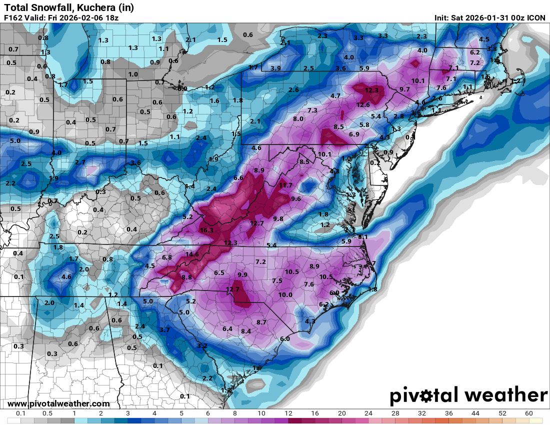
Minus the Carolinas from this weekend That's a nice looking swath of snow

-
It knows where Mt psu is lol 1 little purple shade of intense snow
-
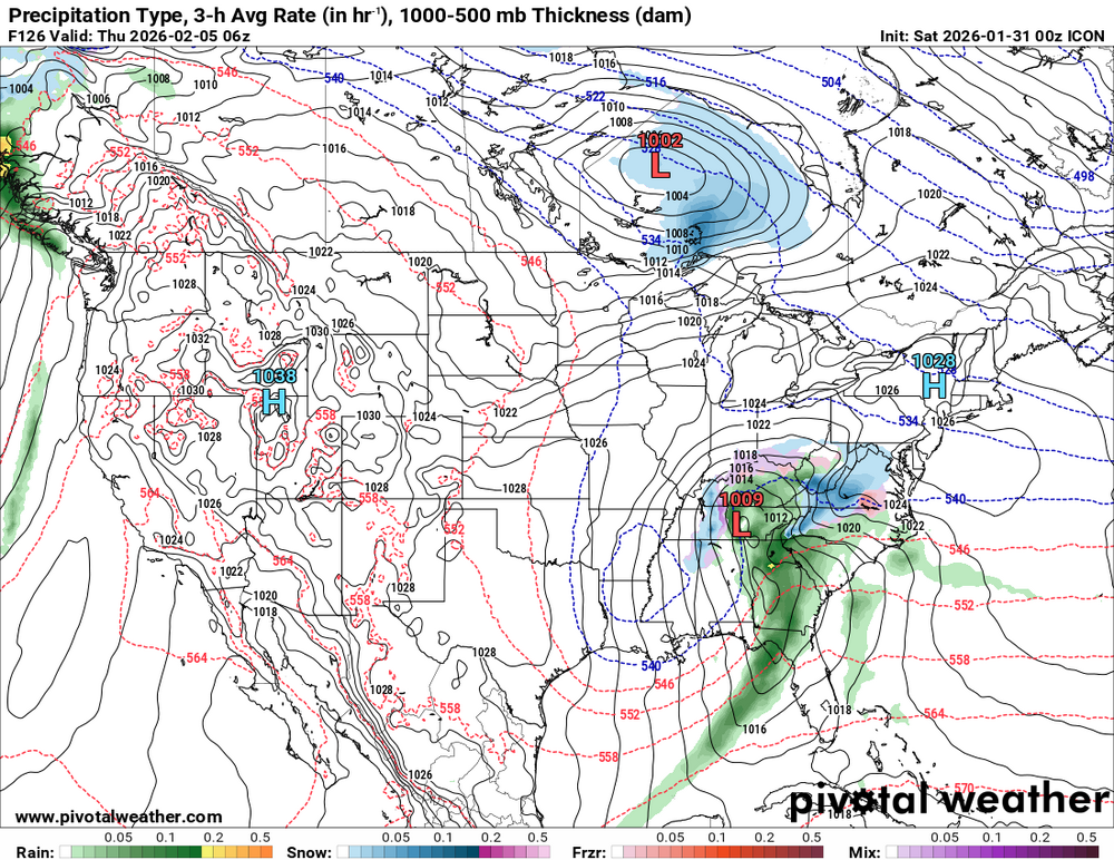
Icon looks interesting
-
It's there but much weaker but its actually a little better compared to its 12z run.
-
For My yard it would be a C at best. Sitting at 12" with my seasonal average being in the upper 20s. If I fail to make it to 20" on the season that would be 5 winters In row. Something that has never happened since records started at HGR in 1899. Actually the current 4 year stretch is the worst on record for HGR.
-
No doubt will get the north trend that we dearly needed this weekend lol.
-
6 hours
-
The Jan 31 Potential: Stormtracker Failure or 'Tracker Trouncing
Chris78 replied to stormtracker's topic in Mid Atlantic
Jv model. 24 hours behind even the icon and rgem lol -
The Jan 31 Potential: Stormtracker Failure or 'Tracker Trouncing
Chris78 replied to stormtracker's topic in Mid Atlantic
Holy shit that's hilarious -
The Jan 31 Potential: Stormtracker Failure or 'Tracker Trouncing
Chris78 replied to stormtracker's topic in Mid Atlantic
The thing that gives me a little hope is how far west the snow extends. The low cutting off further north is very believable in my opinion. It's a different set up but last weekend we bled north seemingly every model run the last 2 days. I'm further west than you and need more of a trend but I don't think anyone south of the M/D line is out yet. We need to start seeing a positive trend today though imo. -
The Jan 31 Potential: Stormtracker Failure or 'Tracker Trouncing
Chris78 replied to stormtracker's topic in Mid Atlantic
When does the GFS fold? 6z or 12z? -
The Jan 31 Potential: Stormtracker Failure or 'Tracker Trouncing
Chris78 replied to stormtracker's topic in Mid Atlantic
Need another model on board. -
The Jan 31 Potential: Stormtracker Failure or 'Tracker Trouncing
Chris78 replied to stormtracker's topic in Mid Atlantic
We will know in the next 45 minutes or so -
The Jan 31 Potential: Stormtracker Failure or 'Tracker Trouncing
Chris78 replied to stormtracker's topic in Mid Atlantic
Would be nice to get another model on board. Gfs vs. The world usually doesn't end well -
Gfs is a JV model?