Chris78
-
Posts
5,226 -
Joined
-
Last visited
Content Type
Profiles
Blogs
Forums
American Weather
Media Demo
Store
Gallery
Everything posted by Chris78
-
Jan 24-26 Weekend Snow and Sleetfest Model Thread Part Tres
Chris78 replied to H2O's topic in Mid Atlantic
If the M/D is pinging by mid morning that would be a poor showing from the globals. -
Jan 24-26 Weekend Snow and Sleetfest Model Thread Part Tres
Chris78 replied to H2O's topic in Mid Atlantic
Nam has given warning shots for previous storms that no one took seriously. Hopefully it's out to lunch but as we get closer in I'd be more concerned. Would like to see it cave here soon. Time is running out -
Jan 24-26 Weekend Snow and Sleetfest Model Thread Part Tres
Chris78 replied to H2O's topic in Mid Atlantic
That's 18z lol -
Jan 24-26 Weekend Snow and Sleetfest Model Thread Part Tres
Chris78 replied to H2O's topic in Mid Atlantic
Will- how does that compare to 12z -
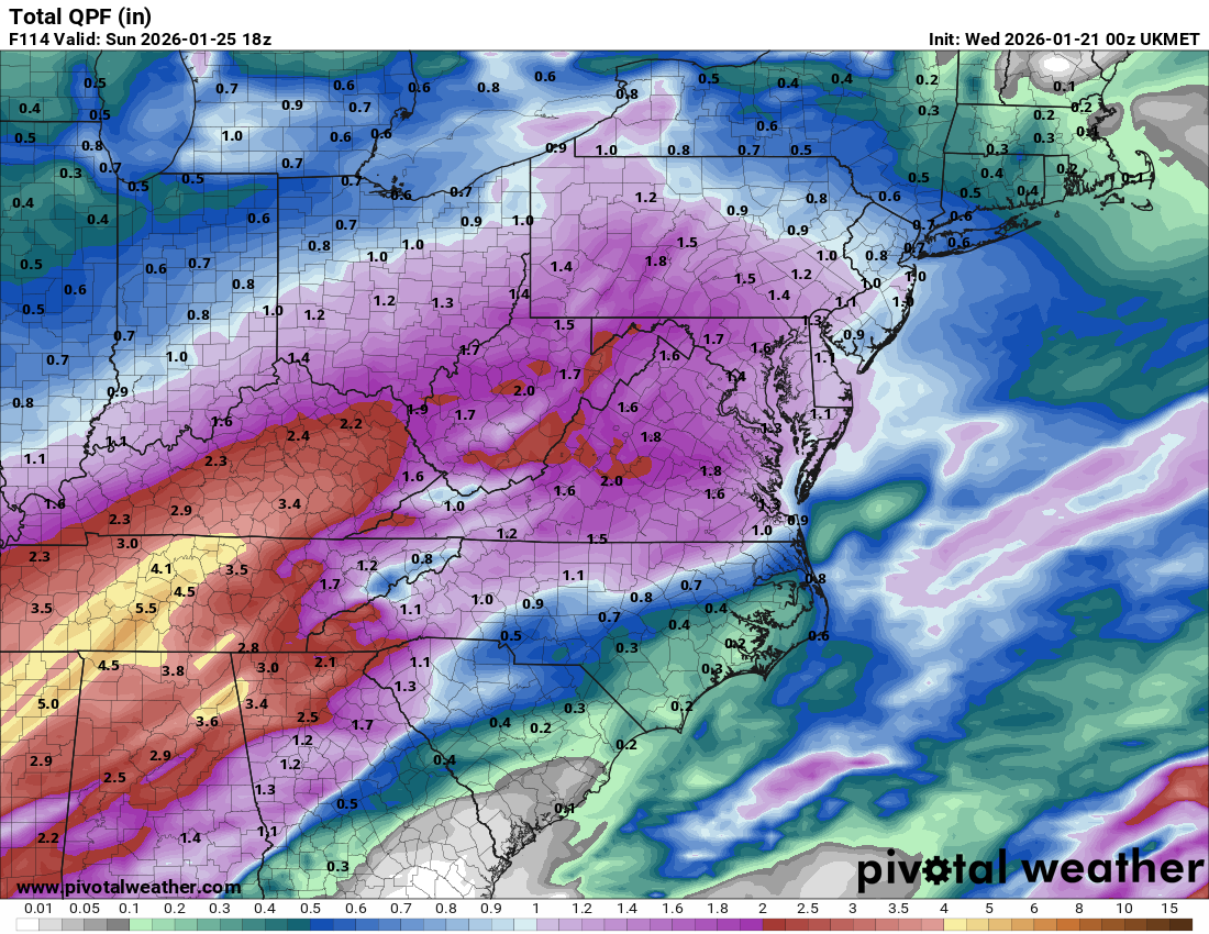
Can someone post the qpf maps to compare 18z to 00z
-
The 850mb low needs to track south of us. If it tracks NW of our area were most likely going to dry slot.
-
King GFS?
-
Even if they met in the middle that would be a nice improvement
-
January 24-26: Miracle or Mirage JV/Banter Thread!
Chris78 replied to SnowenOutThere's topic in Mid Atlantic
Can confirm grocery stores are busier today than yesterday. And will be busier tomorrow than they are today. Totally getting rocked today. -
And we still got double digits
-
Nws has never even heard of it.
-
The individual members look better overall Tham 12z. Less northern ones.
-
Can you post the other 3 hours maps for the storm lol
-
January 24-26: Miracle or Mirage JV/Banter Thread!
Chris78 replied to SnowenOutThere's topic in Mid Atlantic
I'm a SM at a grocery store chain. I can confirm the panic has already started. The next 3 days should be wild. We are expecting a record sales week for my store. More sales than the first few weeks of covid. It's looking like the company overall will break there all time record for weekly sales. -
Definitely tomorrow if guidance remains the same
-
Looking at the 3 hour qpf panels on the Euro for Sunday morning It's absolutely weather porn. @bncho your to young to look lol. Between 7am and noon theres 2- 3 " an hour rates and thats with 6" + amounts on the ground already.
-
Let's hope that's not correct. Too much of a good thing.
-
That's really perfection. Let's lock that in now lol. All the ensembles should calm the nerves a little
-
That weather channel snow totals map is going to look really silly
-
This just got alot more complicated with phasing so far west. Not the simple west to east big overrunning event that was depicted just 24 hours ago. Possibilities of a bigger reward but also increases the chance at a disaster IMO
-
You sure about that?
-
Do you have the kuchie lol?
-
This is roughly the QPF that falls prior to the changeover in and around DC. Pretty intense but if the trend continues.... .

-
The north trend started way to early.
-
That was going to be a beat down. Might be some crazy naming the next few days.