

winterwx21
-
Posts
4,482 -
Joined
-
Last visited
Content Type
Profiles
Blogs
Forums
American Weather
Media Demo
Store
Gallery
Posts posted by winterwx21
-
-
1 minute ago, Stormlover74 said:
hope so too. No complaints considering 3 days ago I threw in the towel on this one
Yeah a few days ago I (like most people) thought it was just gonna be a coating to an inch or two mostly on colder surfaces for our aarea. Very happy to get a nice high impact moderate snowstorm. It's been a couple years since we've had to have streets plowed like this.
-
 1
1
-
-
Just now, Stormlover74 said:
Heaviest its been in 2 hours
Yeah it's picking up nicely. I have 5" here so far. I think we should at least be able to get to 6. Beautiful out there with the wet snow coating the trees. Best storm in a long time.
-
1
-
-
10 minutes ago, nycsnow said:
CMC coming up next hopefully follows gfs
It's a little south of its 12z run with a sharp cutoff for NW New Jersey, but very nice for our area.
-
2
-
-
3 minutes ago, EastonSN+ said:
Where is Forky.
He had said that this could be rain up to Albany (lol), so no surprise that he's quiet now.
-
 2
2
-
-
1 hour ago, Brian5671 said:
Hopefully we can get 2 or 3 events before it breaks down...
12z CMC gives us a decent event on Saturday. Hopefully this is our big week.
-
2
-
-
8 minutes ago, RU848789 said:
Come on in, the water's fine!!
Haha reminds me of the Kick The Can episode of The Twilight Zone.
Anyway I'm so glad this trended in the right direction and we're actually gonna get lucky. I wasn't too high on this threat a few days ago. Looking good for at least a 4 to 6 inch storm for our area.
-
1
-
-
Wow Euro. Makes you wonder if the HRRR was onto something with the big solution. Tough forecast obviously ... 12z model runs should give us a better idea.
-
2
-
-
6 minutes ago, SnowGoose69 said:
I think Upton/Mt Holly might still be cautious, even if the Euro drops more S....might see them go like 2-4 or 3-5 in NYC for the time being or along that general latitude
Glad to see this keeps trending in the right direction. Definitely enough to believe now that it will be more than just a coating to an inch or two for north-central NJ to NYC. I agree that upping it to 2 to 5 looks like a good idea.
-
2 minutes ago, MJO812 said:
This should continue to trend south a little more. Let's see 18z and 0z.
Big runs
Time to enjoy the afternoon and evening on Super Bowl Sunday. Not even gonna look at a crazy 18z NAM run lol. I'll be back to look at the 0z runs.
-
3
-
-
Just now, Allsnow said:
Idk, I guess I like a coating to an inch on the grass for us. I need to see more shifts tomorrow before thinking 2-3 IMO
Yeah I think a coating to 2 inches is a good forecast for our area right now, but hoping it trends a little better so we can increase it to 1 to 3 tomorrow.
-
8 minutes ago, Allsnow said:
Euro going to bump south this run
Do you think our area can pull off 2 or 3 inches? The significant snow will be to the north, but I'm hoping we can get a couple inches here.
-
2 minutes ago, cleetussnow said:
Heres the PD3 rainer: this will go over the top of NYC with that high position and congrats buffalo.
Today's Euro has cold air in place with the storm missing well to the south. Long way to go figure out what's gonna happen, but it looks like our best potential so far this winter.
-
3 minutes ago, MJO812 said:
Gfs brought back PD3
CMC has the threat next weekend too. At least we have another possibility if Tuesday fails.
-
1
-
-
CMC changes it over to snow even well south of the city, but the problem is the period of snow is too brief before it pulls out. So it isn't significant.
So far the 12z models don't look great. Maybe last night was a tease, but we'll see what Euro shows this afternoon.
We know how thread the needle this event is. Some people here have said a slushy inch or two on colder surfaces. Right now I think that's a good early call, but we hope to get lucky with something more significant.
-
1
-
-
2 minutes ago, NEG NAO said:
Some will be excited about this

Most of us haven't been impressed with the setup, but who knows. Maybe we're due to get lucky with one after a lousy couple years. I'm still not getting my hopes up too high, but the models did look better tonight. We need a nice snowstorm around here, so let's hope this keeps trending better tomorrow.
-
2
-
-
Just now, MJO812 said:
I just came back from the atore without a jacket.
Nice to be able to do stuff outside with just a t-shirt on this afternoon.
-
1
-
-
Anyway it's 60 degrees here right now. Time to get outside and enjoy it instead of worrying about the pattern ahead.
-
2
-
-
14 minutes ago, Allsnow said:
Presidents’ Day weekend. But we will have a short window to score something. If not, it’s over with the pac taking over
Yeah President's Weekend continues to look like our best shot at seeing something significant this winter. Cold air in place with Euro showing a storm going to our south. With late February not looking as good now, we really need the period from early next week to early the following week to work out. Tuesday's storm looks like only a very slim chance of working out for our area (at least it's a chance), but there's reason to be more optimistic about President's Day Weekend.
-
2
-
-
3 minutes ago, mikem81 said:
The EURO is too amped for NYC
Quite a bit warmer than what the 0z run showed. Obviously we have a slight chance that this could work out for areas near the coast since it's still early, but right now this is looking like an event for areas to the north and west. The airmass is lousy and we're really gonna need a dynamic solution for it to give us decent accumulations here.
-
Euro changes the rain Monday night over to snow Tuesday morning, but with the lousy airmass it would probably be white rain or just a slushy coating on colder surfaces for the NYC area. Those clown maps are really bad as many have pointed out. We really would need a dynamic solution to get decent accumulations near the coast. Interesting enough to keep an eye on, but I think only a very slight chance that this will work out. Hopefully we'll have a better snow chance President's Day Weekend when we actually have some cold air in place.
Anyway it's 55 degrees here right now. Looking forward to the pattern change and hopefully some snow threats mid to late month, but it's nice to have temps well up into the 50s for a few days now. I'm leaving right now for deer hunting. Great way to finish up the last few days of the season with this warm weather.
-
2
-
-
On 2/2/2024 at 10:46 PM, NEG NAO said:
Similar to the 60's that were predicted here last Friday several days in advance ?
One day later than I said, but it does appear that we have a shot at 60 on Saturday. Might be too many clouds for 60, but I think we'll at least hit upper 50s.
-
2 minutes ago, Allsnow said:
“Absent of some type of major volcanic eruption”
Right but he didn't completely rule out a 50 inch winter absent of a volcanic eruption. He just said we will have a hard time getting one. He realizes we can get lucky and still pull one off.
-
15 minutes ago, Allsnow said:
I’m not denying the winters have been warmer but to say we need volcanic eruptions for 50 inch winter in nyc is ridiculous
Well bluewave didn't say NYC absolutely will not have another 50 inch winter without a volcanic eruption. He just said we will have a hard time doing it.
I do agree with you though that NYC will probably see another 50 inch winter. With climate change snowstorms will become less frequent (warmer weather and more big rainstorms of course), but a few big blizzards are still likely since we see more big storms. Get lucky with a big blizzard, and NYC can pull off 50 inches in a winter again.
-
1
-
-
28 minutes ago, SBUWX23 said:
Not saying I think it's gonna snow. My point is more I don't trust anything coming out of the models right a week out. It still may end up dry or just a little rain.
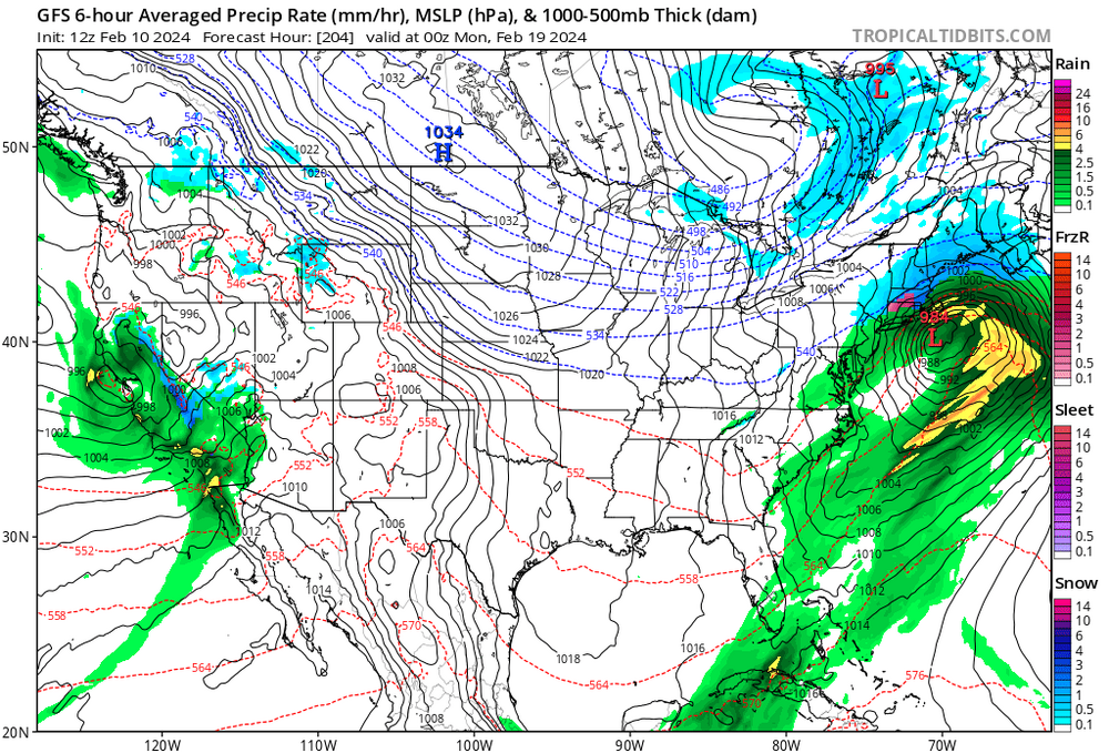
Yeah last night's Euro was south with the storm for the 12th. Now it's showing a big cutter. GFS today is way south. Who the heck knows if we're gonna see a storm monday at this point. Way too early.
2/13 Significant/Major Winter Storm Discussion & Observations
in New York City Metro
Posted
It's coming down at a pretty good clip here. Should be picking up in your area soon as this final band swings through. A little over 5 inches here. A heavier burst with the back edge should get us to between 5 and half and 6. Yesterday I thought we'd be somewhere between 4 and 7, so pretty much what was expected. Not a blockbuster obviously, but a nice moderate snowstorm seems like a great event after getting very little the last couple years. I'm pleased.