backedgeapproaching
-
Posts
3,819 -
Joined
-
Last visited
Content Type
Profiles
Blogs
Forums
American Weather
Media Demo
Store
Gallery
Everything posted by backedgeapproaching
-

The event of the season - 2 days of hell!
backedgeapproaching replied to Go Kart Mozart's topic in New England
Well, that pic was like 630ish AM in my family room before anyone was up. Keep it 60-62 over night. Have 4 zones in house and a jotul stove, no problem heating up areas when I need to. -
The event of the season - 2 days of hell!
backedgeapproaching replied to Go Kart Mozart's topic in New England
Think this is my lowest since I moved here, can't recall for sure. Maybe Feb 16 was close or some other super rad pit type night.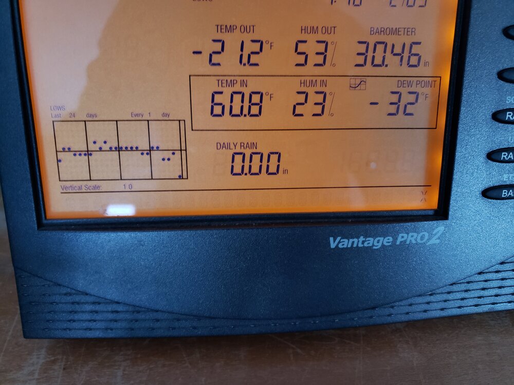
-
Mini overachiever, 25F with SN and 3" new.
-
I dont normally hit any of the local spots on weekends unless friends or family are town, but 9pm on Friday there were so many cars heading from Manchester up the mountain towards Stratton it looked like an endless funeral procession or something. Never seen it like that on a Friday night at that time.
-
Jan 25 2023 Three-fer fer some...
backedgeapproaching replied to HoarfrostHubb's topic in New England
Yes that's my backyard facing E/SE more than due SE I guess. -
Jan 25 2023 Three-fer fer some...
backedgeapproaching replied to HoarfrostHubb's topic in New England
Back of house faces due SE with full exposure. Spine is only 1/4 mile or less from MBY. Feels like the windows might blow in...lol -
Jan 25 2023 Three-fer fer some...
backedgeapproaching replied to HoarfrostHubb's topic in New England
Its insane here right now. Just put up 55mph on my Davis roof mounted anemometer. True house shakers. 28.7F with lt snow and blowing snow. -
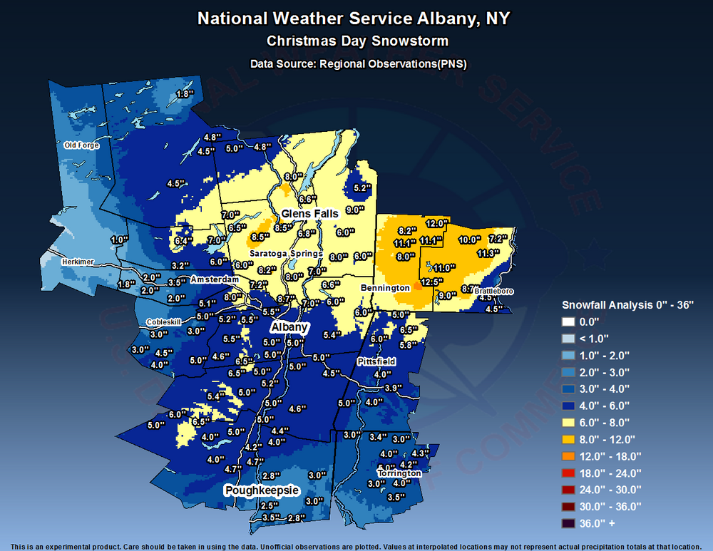
Late to the party posting, but 9-10" range here. No wind at all, love those. So many paste events here this winter, like every single one, whether 2" or 20".
-
There was definitely a weenie band over night through CVT into NH. Rochester VT cocorahs had 12" at 7AM.
-
Friend stopped by earlier that works there and said definitely busiest of the year. 10k+ yesterday. I dont know, maybe everyone thought it was 12"+of fresh as opposed 4-5 of sleet/snow?
-
Not exactly what you like to see pushing mid Jan.
-
Meanwhile, played some backyard soccer down here....
-
I mean yea I figured, but they still put the numbers in there so was taking it on some face value. I have seen some JSpin 40 or 50-1, but they are one offs with zero wind and much smaller events if I recall. Why even put those liquid totals in there then? All 66" is like 50-1 or even more.
-
39" on 50-1 ratios, damn. And those last 6" at 100-1...lol. That depth is nuts too.
-
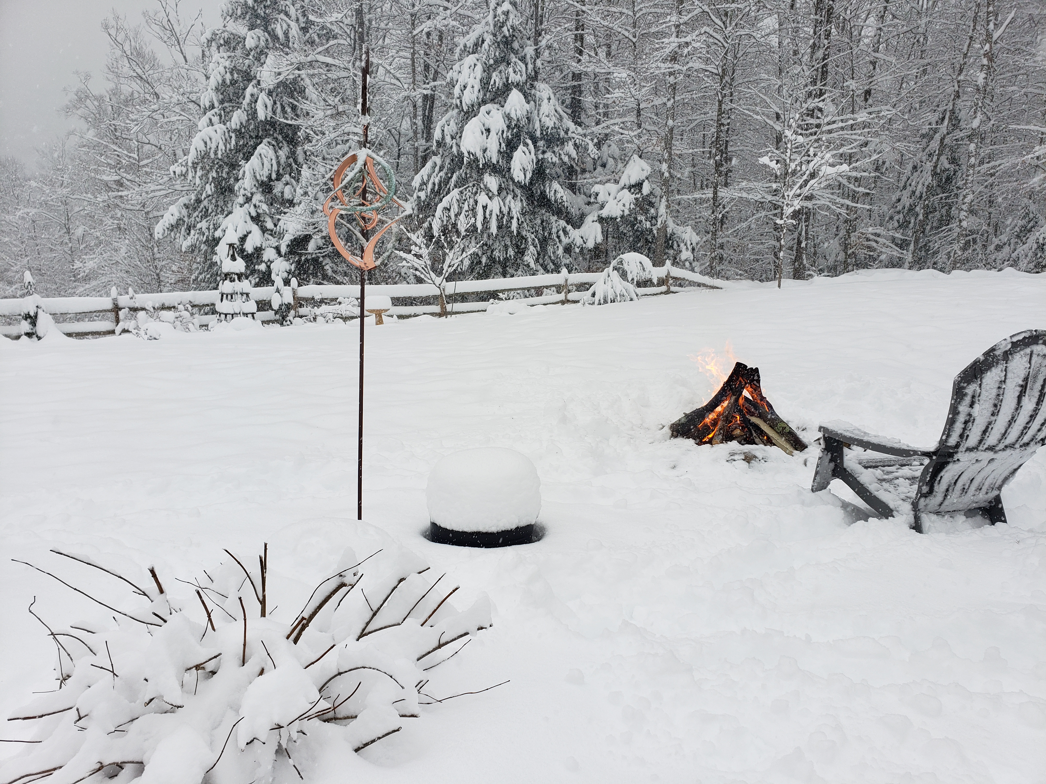
The large evergreens are completely caked, just wet snow frozen solid on them. Wind is blowing here and they are barley moving.
-
ALY had less than 1" here mid day. Some of the mesos did look good, but they can overdone at times around the mtns. ALY throw up a WWA after 3-4" were already down. 4.7" with arctic dust falling now.
-
2 hours of near whiteout. Road is closed from Manchester up to the Stratton/Bromley area.. That almost never happens.
-
HRRR looked pretty snowy for NVT. Had to triple check to make sure, but almost 4" here new since 4pm, getting windy with some blowing snow too.
-
Total freakin' whiteout... down to 30F
-
2.5" SN. 1.65" total snow/rain precip. Winds almost calm now- 44F Depth was 14" yesterday morning and 11.5" this morning at 7AM
-
Green Mountain Power crushes it down here. Power was back in 2 hours even during peak winds last night. Interestingly, only gusted to 29mph on roof mounted Davis after power went out. (peak was 39mph). Probably had 10 windier downslopes events in the past 3-4 years. Seemed like peak winds were in the far western part of SVT more removed from the tucked in Western slopes. Almost off the Taconics it seemed or further downwind from the Greens Spine--at least down here.
-
Power already out before the big winds even get here. Gusted 30-40mph past several hours. Ughh.
-
Nuking here as well. 1.4" on the board. Temp steadily creeping up over the past hour even during S+, up 30.9F. Just a matter of time....
-
'17 snowed xmas day, more up here then down in your area of CT. Was a little nuke though, 4"/hr early that morning.