ILSNOW
-
Posts
1,637 -
Joined
-
Last visited
Content Type
Profiles
Blogs
Forums
American Weather
Media Demo
Store
Gallery
Everything posted by ILSNOW
-
started here as snow
-
12z GFS V16 is clearly the only model with a handle on tomorrow
-
didnt know where to put this National Weather Service Cheyenne WY 504 AM MDT Sun Mar 14 2021 ...HISTORIC AND CRIPPLING WINTER STORM WILL SIGNIFICANTLY IMPACT ALL OF SOUTHEAST WYOMING AND THE WESTERN NEBRASKA PANHANDLE THIS WEEKEND... ...WIDESPREAD BLIZZARD CONDITIONS TODAY...TRAVEL WILL BE EXTREMELY DANGEROUS OR IMPOSSIBLE OVER MUCH OF THE AREA... ...CONDITIONS UNLIKELY TO IMPROVE UNTIL AT LEAST EARLY MONDAY... ...BLIZZARD WARNING REMAINS IN EFFECT UNTIL 6 AM MDT MONDAY... * WHAT...Very heavy snow and blowing snow. Total snow accumulations of 20 to 30 inches with local amounts up to 50 inches above 8000 feet elevation. Wind gusts up to 60 MPH.
-
18z gfs 24 hr snows 3/18
-
12z GFS is drinking again and then this on Thursday
-
GFS in conflict with its self (doubt it happens) and GEM a little further south
-
No way
-
snippet from Milwaukee Satellite imagery was indicating a few convective elements just on the north side of the low, which is forecast to track through the area later this afternoon and evening. The fgen forcing along the front is a bit stronger than forecast and seeing some higher snowfall rates occurring over IA this morning but whether those rates translate east into our area is questionable. Bufkit profiles do show an overlap of this better forcing from the fgen band the dendrite zone, so certainly could support a few higher rates AND The dry slot based on guidance should stay just south of the region but if it does meander north a tad could see more limited snow across the WI/IL border.
-
GFS version a little later in the weekend (likely hood of occurring pretty low) and the v16 for the same time frame
-
Little quiet in here
-
my bad the McHenry snow shield remains in place
-
ukie showing a liitle McHenry love next Wed/Thur
-
real nice fatties now
-
Ended up with about 6-7 here from Sunday night and yesterday just never got into the good snows like cook county did.
-
23z HRRR still bringing it with an additional 17 inches over northern cook
-
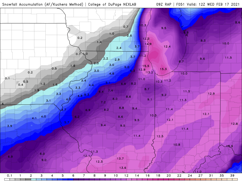
21z RAP still bringing the goods with an additional 14 inches for eastern lake and northern cook county
-
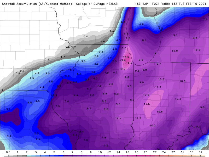
18z rap is ok for you
-
-
Was just going to comment that the main band appears to becoming stationary just north of Evanston those towns under that band are going to get slammed
-
12z HRRR thru 28 hrs
-
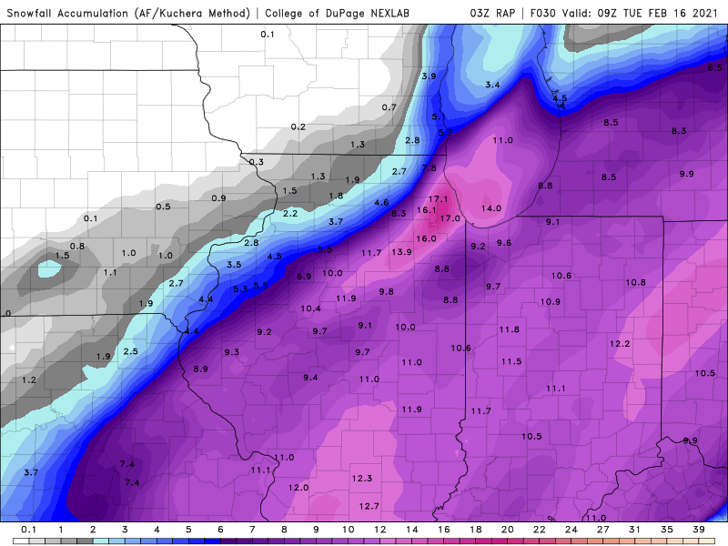
9z RAP
-
thanks for the correction
-
plumes at ORD up to 13 edit includes snow from later in the week as purduewx80 was kind enough to point out ORD is at 9 for this storm.
-
ukie gonna be good for Hoosier
-
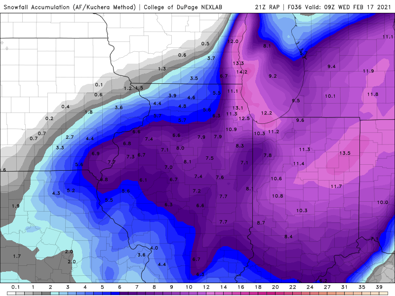
3z RAP still bringing the goods with additional LE ongoing