snowbird1230
-
Posts
503 -
Joined
-
Last visited
Content Type
Profiles
Blogs
Forums
American Weather
Media Demo
Store
Gallery
Everything posted by snowbird1230
-
2021-2022 Fall/Winter Mountains Thread
snowbird1230 replied to BlueRidgeFolklore's topic in Southeastern States
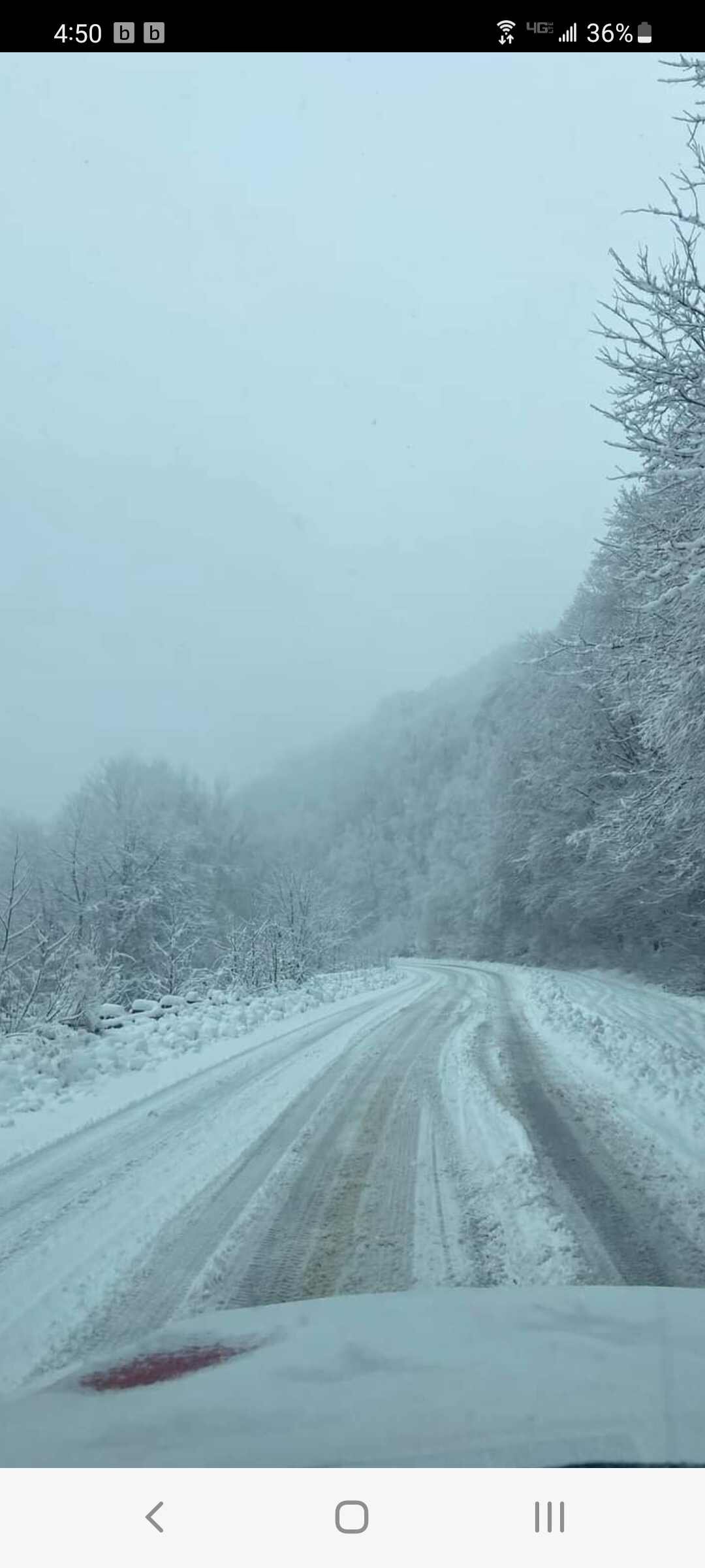
Getting reports of many vehicles stranded on Cherohala Skyway..16" of snow..50 mph winds -
2021-2022 Fall/Winter Mountains Thread
snowbird1230 replied to BlueRidgeFolklore's topic in Southeastern States
Cherohala Skyway 15"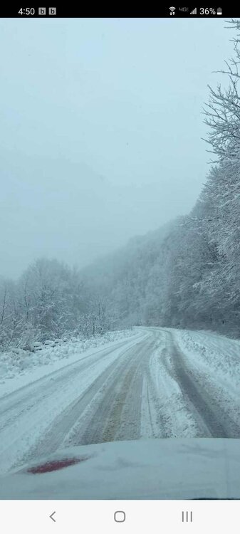
-
2021-2022 Fall/Winter Mountains Thread
snowbird1230 replied to BlueRidgeFolklore's topic in Southeastern States
1-2" throughout Graham County but massive dry slot fixing to work in -
2021-2022 Fall/Winter Mountains Thread
snowbird1230 replied to BlueRidgeFolklore's topic in Southeastern States
Welp 12z Euro and GFS both with a foot for me but my NWS forecast is 100% chance of rain. Anyone else seeing goofy things like that? -
2021-2022 Fall/Winter Mountains Thread
snowbird1230 replied to BlueRidgeFolklore's topic in Southeastern States
Boyer just updated totals. Marshall 1" Waynesville 5" Everyone west of the Balsams 1-4" Most of the higher totals are East of Asheville and around Cashier's and Toxaway -
2021-2022 Fall/Winter Mountains Thread
snowbird1230 replied to BlueRidgeFolklore's topic in Southeastern States
If any of you guys follow DT / WXRISK on Facebook or Twitter..He's saying short range models are very concerning, coming in much warmer. States the possibility of a lot more Ice and much less snow in all of WNC -
2021-2022 Fall/Winter Mountains Thread
snowbird1230 replied to BlueRidgeFolklore's topic in Southeastern States
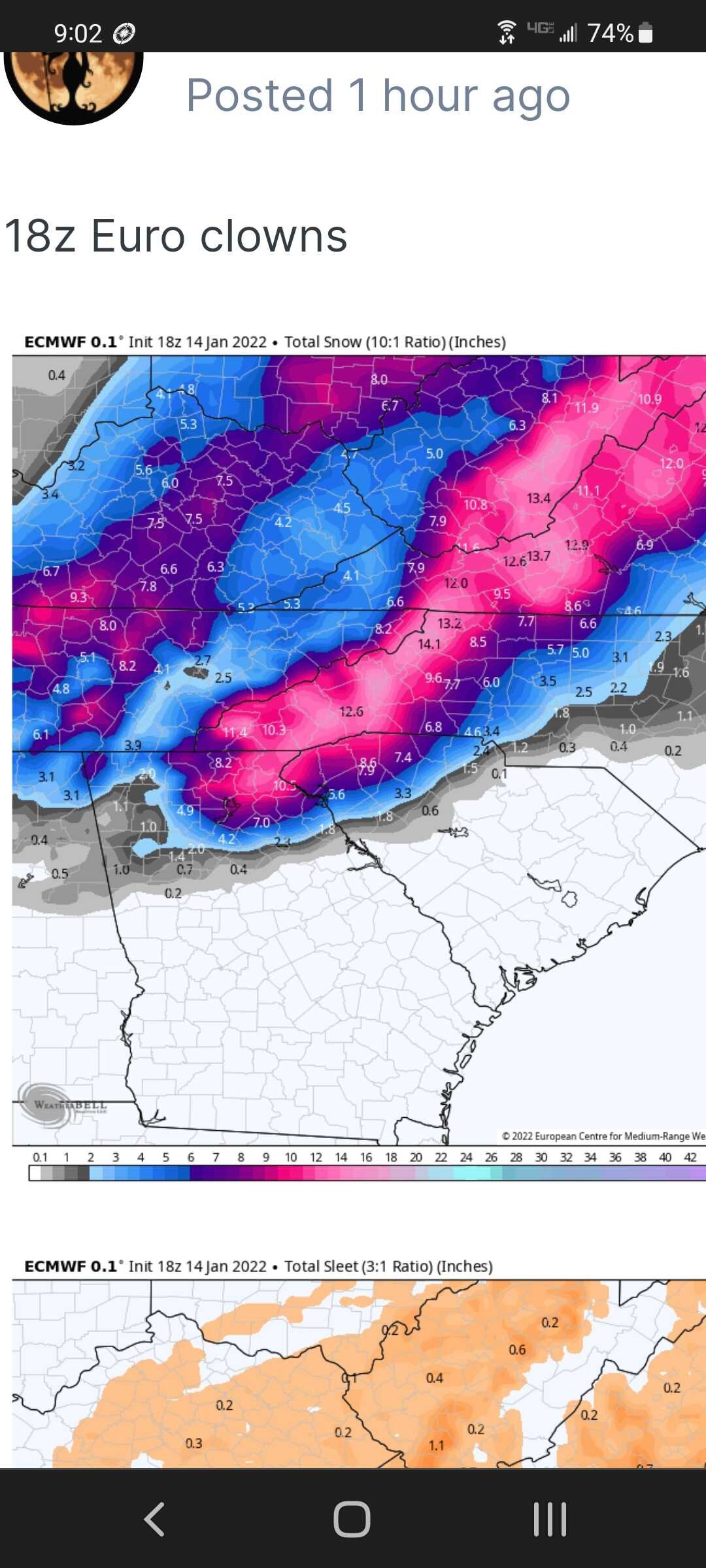
Can someone knowledgeable to the situation help me understand this forecast? This is the 18z Euro. I'm in Graham County , well into the 12"+ shaded area. Yet NWS is only giving me 1/2"- 1" the entire event.. Not understanding all I need to know.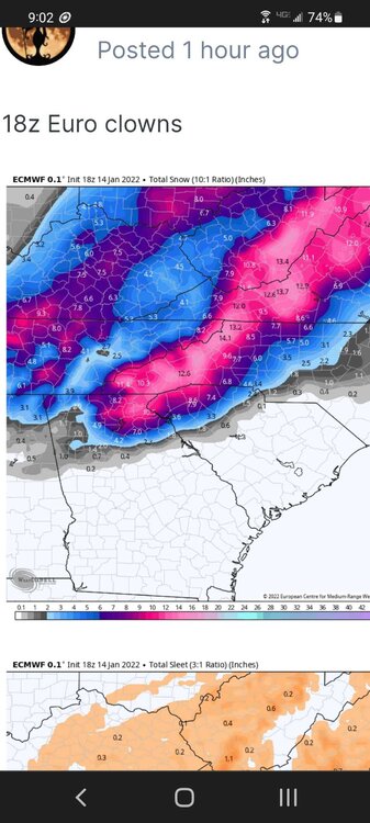
-
2021-2022 Fall/Winter Mountains Thread
snowbird1230 replied to BlueRidgeFolklore's topic in Southeastern States
Enjoy Met.. Graham County under the warning also but then the forecast only gives us 1/2" of snow the entire event. Snowbird out.. -
2021-2022 Fall/Winter Mountains Thread
snowbird1230 replied to BlueRidgeFolklore's topic in Southeastern States
GSP upgrading to Warnings -
2021-2022 Fall/Winter Mountains Thread
snowbird1230 replied to BlueRidgeFolklore's topic in Southeastern States
Will 10:1 be more accurate with this storm? -
2021-2022 Fall/Winter Mountains Thread
snowbird1230 replied to BlueRidgeFolklore's topic in Southeastern States
The dreaded dry slot -
2021-2022 Fall/Winter Mountains Thread
snowbird1230 replied to BlueRidgeFolklore's topic in Southeastern States
Except The Smokies, Graham,Swain and Cherokee counties -
Tellico's gonna like that map!!
-
2021-2022 Fall/Winter Mountains Thread
snowbird1230 replied to BlueRidgeFolklore's topic in Southeastern States
Wow looks like Bryson City and Robbbinsville is out of the game.. -
2021-2022 Fall/Winter Mountains Thread
snowbird1230 replied to BlueRidgeFolklore's topic in Southeastern States
Now heading south -
2021-2022 Fall/Winter Mountains Thread
snowbird1230 replied to BlueRidgeFolklore's topic in Southeastern States
Nam wayyyy North -
I think you posted 2 GFS runs bud.
-
2021-2022 Fall/Winter Mountains Thread
snowbird1230 replied to BlueRidgeFolklore's topic in Southeastern States
Not mine!! Continually shows Graham County getting the shaft!! Lol -
2021-2022 Fall/Winter Mountains Thread
snowbird1230 replied to BlueRidgeFolklore's topic in Southeastern States
Hopefully, RGEM sucked..rain in the mountains -
2021-2022 Fall/Winter Mountains Thread
snowbird1230 replied to BlueRidgeFolklore's topic in Southeastern States
Surface not verifying huge snow totals? -
2021-2022 Fall/Winter Mountains Thread
snowbird1230 replied to BlueRidgeFolklore's topic in Southeastern States
Frozen precip from Chattanooga to Myrtle Beach lol -
2021-2022 Fall/Winter Mountains Thread
snowbird1230 replied to BlueRidgeFolklore's topic in Southeastern States
No questions about cold air with the NAM -
I don't buy surface map.. something off when it doesn't show the spine of the Apps of TN and NC with no heavy snow.
-
Looks like an absolute mess.
-
2021-2022 Fall/Winter Mountains Thread
snowbird1230 replied to BlueRidgeFolklore's topic in Southeastern States
GSP with really not much to say..said they favored the ECWF more... then my forecast in Graham County came out with mostly rain..very confusing sometimes