PivotPoint
-
Posts
714 -
Joined
-
Last visited
Content Type
Profiles
Blogs
Forums
American Weather
Media Demo
Store
Gallery
Everything posted by PivotPoint
-
And to be honest, I’m sure that I’m over thinking it this far out especially considering I’m talking about temps. Temps shouldn’t really be something discussed until models are in their deterministic range, however, I just wanted to point out that I think blocking needs to have cold below it to supply us with the ingredients we need. That’s all. Think that’s a fair observation!
-
I agree with that. However even if it doesn’t cut I still think we need help from some Ridging out west to allow for amplification and tapping whatever cold air there is for a SW
-
Science is about being oppositional. And I was just saying my thoughts, Yoda said”I have to find something wrong”. Did not start this one, as I typically get blamed for this stuff. Sheesh
-
The tweet you posted from Webb is fine and well, by he says “Cold? Sure.” Then shows a 10-15 day ensemble mean of 500mb that, yea, has a great west based huge NAO and slight ridging. It is a good look. But people underestimate the issues that we “DC” folk have with temps. PSU cited a the December storm as “see, it was almost cold enough and it was only mid December”. And it actually kind of proves my point. DC got nothing from that. And the reason was partly track but mostly mid-levels could hang on and we were flooded with WAA because our airmass wasn’t stout enough. Fast forward, Jan and Feb should fix that issue, right? I mean, another moth of cold building up would be enough to help a marginal setup, one would assume. I’m making the point that the cold is there like we would typically expect, and what looks like a great 500 could be great for Winchester on west, even with a great block and confluence to the north. We’lol have to wait and see but this isn’t a “he knows more, he’s a met, you be quiet” type deal. My issue with temps and what the block has not allowed to happen “building of substantially cold air” I view as a potential factor rolling through even a “good” upper air look.
-
Find something wrong with it? It’s not a tv show lol... there’s nothing “wrong with it”. It’s that the block, Yoda, is blocking “in” marginally cold air and a negative AO is only as useful as the arctic air the region draws from. I’m not saying it can’t snow or that it definitely won’t snow. I’m just not a cheerleader no matter the pattern. I’m saying that we need ridging upstream, plain and simple. Do we HAVE to have it to have snow, of course not. Flukey stuff happens all of the time. I’ve simply stated, however, that huge blocks do us little good if there is a trough out west with marginally cold air in Canada. Fix either of those issues and we we a totally different track and or temp profile. I mean, or you a fan of warm cutters? Because that is what “this” pattern is delivering, even with blocking.
-
Some points in there well taken but hasn’t the Northern PAC had a fairly stable trough through most the second half of dec? I see a low in gulf of AK and ridging so far west it’s on the the other side of the PAC. And to be clear, I’m not asking for a a full alt PNA ridge from the gulf of AK to San Diego, but yes I think that removing the huge + anomaly around Greenland could have an effect on draining some of that cold air out of East Asia. Now I’ll admit that I’m not an expert to be able to explain that’s mechanism. But I will say that having a trough out west with a mediocre cold source for us and cold air locked up in Asia is NOT what we want. I see a huge anomaly over Greenland and can’t help but think that this is part of the atmospheric mechanism that is to not allowing cold to travel to our part of the hemisphere. I’m sure some of my rationale is flawed but I have a hunch that there’s part of it that makes sense.
-
Yea, but we do. The Pacific/North American oscillation is simply a phase that refers to relative amplitude. The PNA (itself) is not a mechanism. It’s a result of a atmospheric mechanism, specifically phase pressure differences over the central Pacific Ocean and Rossby Wave Effect. So yea, we need PAC help to get a ridge out west
-
I’d agree with that last sentence and was kind of my whole point. And I’ve also said that now for over two weeks so it’s not like I’m just jumping on the negative train here. The PAC needs to reshuffle for our chances to improve. I know that’s kind of simpleton logic, but honestly I think things get too tech-y in here sometimes when the current answer (and future improvement) is “sometimes” a little more straightforward. We need our cold source to improve. We need pacific help and some semblance of a mean ridge out west. Then we have a chance that is higher than unicorns and snowmen “it might snow” in this crappy pattern, lol
-
I don’t see how my comment of our current base state is vodooo outcomes. I actually think quite the opposite, I believe my point is that I’m not wishcasting for snow but rather looking at where we currently stand and how we logically roll forward. And with respect to the EAMT events: sure if we get recycling of AN heights that trigger a +EAMT that would bode well down the line for colder anomalies up north... but that’s pretty close to actual vodooo whether that comes to fruition, so
-
Guys and girls, we can get the 500mb to look good all day long... but the surface temps are going to destroy our frozen. Watch: PSU will be saying two weeks from now “the pattern progress the way we wanted it but we couldn’t overcome the AN temp anomalies and our source region”. Something like: “perfect track, bad temps”. I get that that the AK low may retro and we pop a PNA and get our west based block. But we have NO COLD AIR! At least by the time it reaches us from its Luke-cold source region. We need that blocking to disappear and build cold, then recycle 3-4 weeks from low and and enjoy a 2-3 week period of winter. Not being a downer, hope I’m wrong but the AN surface temps are going to be a real issue here folks
-
How is a west based NAO block going to help if our source is warm “relatively”, and the PAC doesn’t improve which is necessary to shut off the flow of maritime air cross the continent. No cross polar flow and a crappy PAC... I’m not sure I agree the PAC doesn’t need to improve for our chances to improve. Maybe I missed your point
-
Lesson learned from this year: stable and early in the season blocking can screw us... badly. The issue here for winter weather this season is simple. Our source region had no time to build up cold and the PAC has a mean trough look. Pretty simple actually. There’s other side dishes in there but the meat and potatoes is there is no cold within 2000 miles to our N/NW. -5, -10 temp anomalies in central Canada have people saying “that’s cold enough for snow”. Well, yes. For them though, not for us. By the time that airmass were to reach us it would be modified and mixed to the degree that it would not support snow down here in the mid Atlantic. The only way to help fox our source region this late in the game would be a SSWE, or perhaps an EPO ridge and +NAO combo that allows cold to build back up for 4-5 weeks, then we hope for a cold March. It’s becoming pretty clear to me that any major snow chances might be a real outside chance (again) this year. I think we’ll probably luck into some times front that has some trailing energy to allow enough cold drainage for snow, but there’s a real chance that NOVA/DC metro gets blanked. Even if it does snow I bet we have surface temp galore problems not having any juice behind an artic high or even a modified front. Not feeling warm and fuzzy about our chances through foreseeable future. Maybe mid feb-March will produce.
-
Looks like a cutter I read what PSU posted about cold air or lack thereof. Good read and makes sense. There’s just no cold air anywhere to be found, and with a warming climate I feel like we need more help to get snow than 20-30 years ago. That said I do think we loose that crap PAC but how long does that take is the question. We’ve done this kick the can deal for a couple winters now
-
I guess what I was getting at is the there is a mean 500mb trough off the west coast that with a fairly active PAC flow means that any PNA that does develop gets eroded quickly and frequently. I’m not saying that a brief ridge can’t develop and time us up, however I also know that see the intermountain west get hammered with snow is not usually a snow look for us. To your point though, with a mega block we probably do want an active west and PNA matters less since our risk of cutters is greatly reduced by the significant blocking. I’m always suspect of these highly anomalous teleconnections (like a massive -NAO phase). Additionally, most the literature I have read about the seasonal variability of blocking suggests a duration of 5-30 days being within a normal distribution. So if we have already been experiencing a-NAO on the mean, then each few days that pass we risk cycling out or losing that look altogether. Long and short, I’m very happy with the Atlantic but feel like the PAC could sour our snow chances but not completely shut it out.
-
Not at all. If you go back and read my posts starting 3+ weeks back I talked about how I thought that LR looked good for cyclical blocking regime and an Atlantic that is not fighting us. Haven’t had that combo in awhile. I read maps at an amateur level anyways. So it probably doesn’t matter lol. But no, I just see what I see. And when it looks good I say so. When it doesn’t, I say so. It just happens that it looks not good more than it looks good. That’s our climo
-
It’s more over you. Leesburg SH.
-
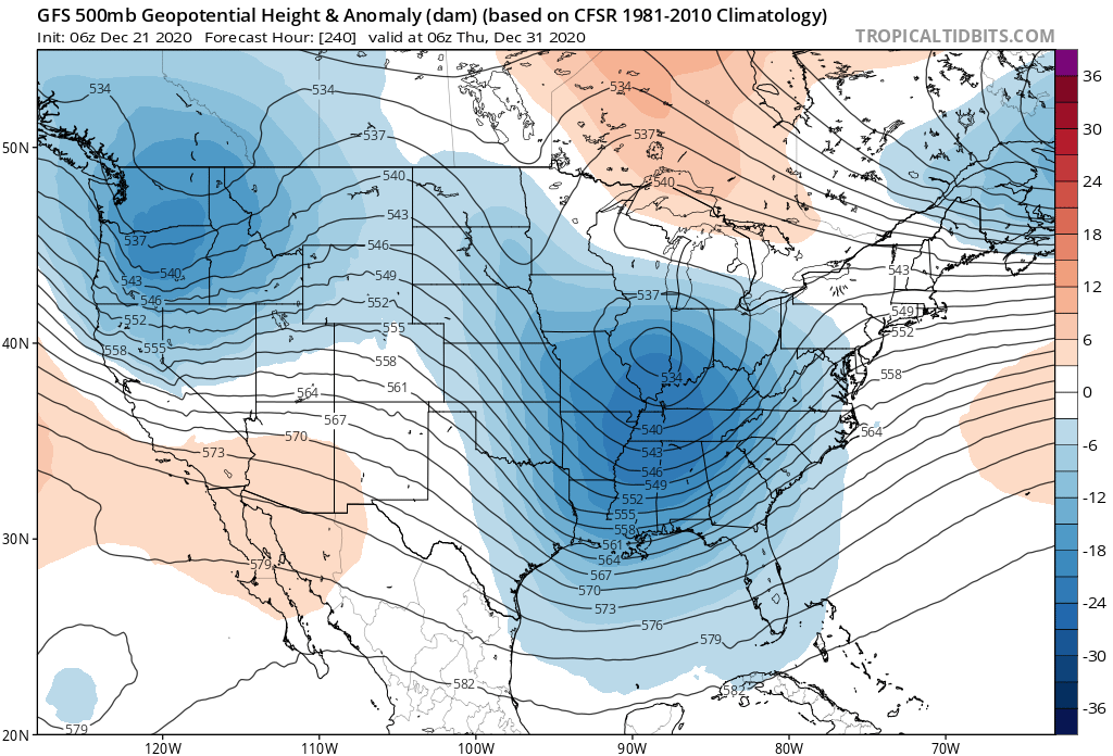
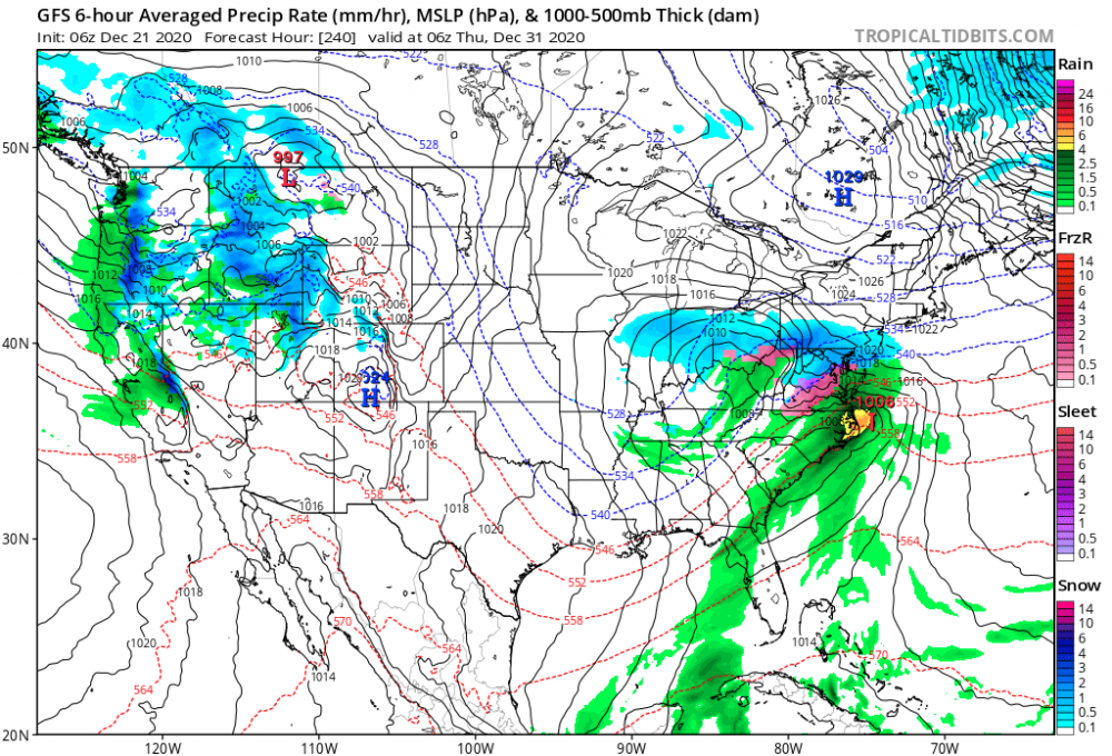
Unfortunately, the blue is all types of wrong out west lol. It’s always 10 days away @psuhoffman lol. Crazy block though Again, one frame at 384 hours. And flow looks pretty flat coming off the PAC. I’m beginning to worry that we won’t score with a bad PAC and troughing south of AK. Seems like that a recipe for warm wet, cold dry sequence over and over again. Can’t not expect it though. That’s kinda La Niña for you
-
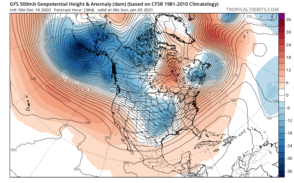
Kind of knit picking here, but again, that blocking (as modeled) is too far east for us to get the amplification we need. It will change though so that’s good lol eta: and also close to a 50/50 but it’s not connected. Partly due to the position of blocking in East-Greenland
-
I wouldn’t agree that the period we’re entering into is a “classic” look. Trough through California and a weak high to our north will probably fail more times then not. I do like though how there seems to be a consistent reload of the general pattern after each vort pass over the next 7-10 days. I would agree that the 96 woof stuff is pretty ridiculous this far out. If someone with knowledge wants to do that be my guest, but his own peers will be like, “come on man”.

-
Doesn’t that kind of suggest a more horizontal flow and less amplification for us? That WAR too is the type of confluence we’d like either, correct?
-
Yea, I never understood woofing and calling out HUGE dates like a 96 storm. Those storms are just so rare and anomalous, it’s like when you put that out there you’re encouraging people to amp a “possible” storm and promote ideas that almost NEVER happen. It’s a little sensational, imo. I like the period coming up after xmas cutter. But there’s a lot of issues I see too, for example an unstable PNA regime, East based blocking. Doesn’t seem that we have a lot of cold air around either. Each year that goes by seems harder and harder to generate the surface temps we need for a good snow storm.
-
This is a signal for cold dry alternating with warm and wet, imo. The anomalies in western Canada is a result of troughing below AK and that split flow that Ralph mentions below. So I see this as cold periods followed by an undulating PNA, which isn’t horrible but won’t allow amplification without a steady PNA that drives to dig south. Yea, it looks like (to me) that the axis of the entry point of the northern branch is at too high a latitude for us to see the streams merge where we need them to. We need that ridge to be closer and further down in the west coast, and the ak trough to migrate so it stops squeezing that west coast ridge. That will pump up heights in the middle of the country which gives us that alternating cold dry, warm wet.
-
Stupid one-eyed monster in AK needs to go away. So many things working for us. This is not one of them

-
Light flurries in Arlington. Nice
-
That's cool. Wow, I didn't know we only had one HECS in 50 years without a -NAO. Geeze. Timing seems to almost always be a must at my latitude, but it's fascinating that if you just go 50-70 miles to my northwest, you can score with with a less than perfect solution. I really feel like our snow success this year (as well as many other winters) is especially linked to how the PNA performs. We all know that a +PNA can influence higher chances for gulf moisture, and of course features an above avg chance we see some cooler temps on this side of the country. With that said, I also have a sense that we see (hopefully) a few periods of blocking, especially into the early part of January, as ridging in (or near) our ideal NAO space seems to be (possibly) the preferred position this season. I noticed back in October that the north Atlantic was rotating higher heights through Greenland/N. Atlantic, at least more than I have seen prior to the last couple of winters. I always feel like October through early November can give us a glimpse of some of the pieces that become featured during winter. Totally anecdotal though. I can't prove it. Long and short - I'm really hoping for a PNA that cycles through some stable + periods. I feel like we will we get a couple "hum-dingers" if we get this.